Parking Lots and Rice Paddies: Designing Resilient Urban Water Systems

Brian McGrath, New York. 
6 December 2012

Many voices. Greener cities. Better cities.

I left Springfield to study architecture in 1974, two years after passage of the Clean Water Act of 1972. The first watershed association in the U.S. was established the Connecticut River Watershed Council two years before my birth in 1956. I can measure my return to the Connecticut River Valley some four decades later against the socio-ecological changes in the water and land of the Connecticut Valley as the result of water management following the introduction of Environmental Protection Agency in 1970, but most importantly, the social urge to abandon the old industrial centers, and build a new city within the old tobacco and corn fields of the Connecticut Valley.

As William Cronon has demonstrated in his book Changes in the Land: Indians, Colonists and the Ecology of New England,new social practices can completely alter an environment in a generation. Comparing 17th century explorers accounts of the first encounters with the Native American landscape of New England with the with descriptions of the colonial landscape at the end of the 18th century, Cronin situates historical change within socio-ecological processes tied to belief systems and economic practices. He concludes that the deep ecosystem knowledge that the Native American’s had was not recognized by the colonists bent on an attitude of “land improvement” rather than ecological stewardship.

Returning home, I felt a similar kind of urban knowledge was lost, as my parents’ “greatest generation” lost contact with the institutions, social alliances into which they were born.

This year I began an urban design research project on recent urbanization in the Mae Ping River Valley city in Chiang Mai, Thailand. My research framework is to compare indigenous and scientific practices in water management in relation to urban resilience in the face of climate change as part of a sabbatical leave generously provided by The New School. I was drawn to Northern Thailand in order to understand the famous muang fai gravity-fed weir and canal based irrigation system for wet paddy rice farming that evolved over many centuries. My home in Chiang Mai affords me an intimate view of this system along the Mae Kuang River, a few hundred yards below a community-managed weir.

For a New Englander, this flexible, adaptable and resilient water management practice reminded me both of the wetland engineering qualities of the native North American beaver, and Native American socio-ecological knowledge described by Cronin. The muang fai remain remarkable examples of community based natural resource planning, design, management, adaptation, and resource sharing, even in the face of extreme pressures of urbanization and centralized government development policy.

String of industrial mill towns along the Connecticut River in 1895: From north to south: Northampton, Holyoke, Chicopee and Springfield, Massachusetts, and Enfield and Windsor Locks, Connecticut.

This work, far afield, as has often been the case during the previous decade of my life, has been regularly interrupted as I try to return to the place of my birth and upbringing to care for my parents, aunts and uncles as the normal end cycles of human life take its toll on their generation. What started as an exploration of indigenous socio-ecological practices in Thailand has resulted in an inverted telescope looking at the American landscape from Southeast Asia, much as Benedict Anderson describes in The Spectre of Comparisons. Through this inverted telescope, I began to compare the muang fai system’s network of irrigation dams and canals to the Connecticut Valley’s legacy of beaver dams and industrial mills.

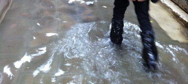
Around Springfield, alongside and replacing this concentration of early urbanization at water power sources exists a landscape of shopping malls, industrial parks and housing subdivisions, which since the 1970’s has been more and more carefully managed through the creation of point-source water pollution restrictions, wetland boundaries around non-point pollution sources. Since selling our family house in the city of Springfield, I have a close-up view of this new landscape.  I now often stay on of the hotels clustered at exit 47E on Interstate 91, just over the state line from Springfield. Motel 6, Red Roof and Hampton Suites all have robust storm water management systems between their parking lots and the Freshwater Brook in Enfield, Connecticut, and the shopping malls at Enfield Square and Enfield Commons form a super-block with the fenced brook as its ecological “commons”.

Top: Rice paddy irrigated from a muang fai dam (circular inset) along the middle reach of the Mae Kuang River near Ban Nam Rongkuhn. Bottom: Freshwater Brook passes through the shopping center parking lots comprising Enfield Square and Enfield Commons, before passing under Interstate 91 and forming a mill pond at the Thompsonville hydropower dam (circular inset). Credit: Martina Barcelloni Corte

While in Northern Thailand I am studying new patterns of urbanization in relationship to indigenous water management practices based on diverting water to wet rice paddies. In New England I witnessed the development of more and more intricate water management obsessed with removing water from parking lots. While the control of non-point pollution from America’s ubiquitous asphalt parking surfaces has put us at some distance to water bodies in everyday life, it has also successfully contributed to the remarkable restoration of the Connecticut River Watershed as a whole.

However, the New England mill, like the Northern Thailand muang fai provided an example of direct engagement with water, but based on renewable energy rather than subsistence food production. Through this study I hope to develop design tools combining scientific knowledge about maintaining ecosystems, with socially resilience indigenous practices of adaptation and self-reliance.

Twin Storms

View from Mount Holyoke, Northampton, Massachusetts, after a Thunderstorm—The Oxbow, Thomas Cole, 1826, from the collection of the Metropolitan Museum of Art, New York.

The ancient volcanic ridge of the Holyoke Range cuts across the Connecticut River between Northampton and Holyoke, Massachusetts, creating the famous oxbow scene for Thomas Cole’s seminal landscape painting View from Mount Holyoke, Northampton, Massachusetts after a Thunderstorm. Like the river, Interstate Route 91 now cuts through the weathered ridge forming the northern edge of Jean Gottman’s Bos-Wash megalopolis, and travelers with skis strapped to their roofs know they are entering the heartland of rural New England when they pass through the Holyoke Range.

A similar feeling of arrival greets a driver from Bangkok when crossing the last ridge of mountains separating the ancient valley Kingdoms at Lampang and Chiang Mai, as one descends into the broad belly of the Ping River Valley into the domain of the ancient Lanna Kingdom in Northern Thailand. Teak forests give way to a fertile plain of villages, fruit orchards and rice paddies. A vast, intricate and indigenous irrigation network maintains a lush green carpet among a patchwork of new resorts and subdivisions, even in the dry months of the monsoon cycle.

By coincidence, cross mountain drives across both river valleys last year revealed the urgency of new design and water management practices to enhance urban resilience in the face of climate change. In August, 2011, I found myself traveling in the wake of the late season Typhoon Nok Ten, which dropped an unprecedented amount of rainfall across the already monsoon saturated mountains and plains of Northern Thailand. The storm triggered in the following months the most devastating flood in Thai history, crippling the high-tech and automobile industrial estates in the Central Plane north of Bangkok. I was back in the U.S. for less than a week when I again found myself driving in the wake of a devastating storm as I returned to New York on the tail of Hurricane Irene. Unlike Hurricane Sandy in October 2012, Irene spared the coast of the megalopolis from the feared storm surge, but like Nok Ten, Irene released an unprecedented amount of rain into the upstream watersheds, especially the Connecticut River and its tributaries.

While Cole’s painting is said to metaphorically depict the clash between civilization and nature, the scene depicting a severe thunderstorm about to descend on a peaceful agricultural valley depicts a very real event of ecological disturbance. The twin storms heightened my sense of urgency in discovering how the urbanized countryside in both Connecticut and Ping River Valleys might be designed to be more resilient in the face of unpredictable weather patterns. The initial study begins with close observations in the two sites in early spring through late summer of 2012.

This blog post takes the form of a photo-diary, beginning in April, the Thai New Year, in New England, then taking in the second-crop rice harvesting and new year planting cycle in Northern Thailand, before returning to the wet beginnings of late summer back home.

April, 2012, Enfield Commons, Connecticut, May, 2012 Ban Nam Rongkuhn, Chiang Mai

A dry spring allowed me access to Freshwater Brook, enabling me to conduct an initial survey of the various drains, catch basins, pipes, retention ponds and wetlands. A winter of snow removal and salting had ended the month before. Arriving in Chiang Mai at the end of dry season, it was time for stream dredging and embankment construction for flood control and second rice crop harvesting.

Left: Snowplows finished for the winter line up behind Enfield Commons, Enfield, Connecticut. Right: Just before the monsoon starts in earnest, the Thai Royal Irrigation Department dredges the Mae Kuang River in order to prevent flooding. Credit: Brian McGrath.
Left: Freshwater Brook behind Enfield Commons, Enfield, Connecticut. Right: Embankment reinforcement, Mae Kuang River. Credit: Brian McGrath.
Left: Parking lot grated drain, Enfield Commons. Right: Access to piped irrigation ditch, Ban Nam Rongkuhn. Credit: Brian McGrath.
Left: Parking lot drainpipe outlet to Fresh Water Brook, Enfield Square. Right: Muang fai irrigation canal, Chiang Mai. Credit: Brian McGrath.
Left: Parking lot drainpipe outlet to Fresh Water Brook, Enfield Square. Right: Irrigation canal, Ban Nam Rongkuhn. Credit: Brian McGrath.
Left: Snow plowing equipment and salt storage sheds, Enfield Square. Right: Rice harvesting, Ban Nam Rongkuhn. Credit: Brian McGrath.
Left: Shopping carts at the edge of the Freshwater Brook wetland boundary, Enfield Commons. Right: Rice harvesting machinery, Ban Nam Rongkuhn. Credit: Brian McGrath.
Left: Shopping carts along the Freshwater Brook wetland boundary, Enfield Commons. Right: Burning rice fields after harvest, Ban Nam Rongkuhn. Credit: Brian McGrath.


Top: Detail of Ban Nam Rongkuhn rice paddies along Mae Kuang River, top. Bottom: Enfield shopping centers along Fresh Water Brook. Credit: Martina Barcelloni Corte

May-August, 2012 Ban Nam Rongkuhn, Chiang Mai, August 2012, Enfield Commons, Connecticut,

With the start of the monsoon, I had the opportunity to watch initial plowing and dike rebuilding and the first diversion of water to nursery rice paddies. Next the surrounding fields were plowed, and transplanting occurred just before I left in early August. Some fields were more simply planted with a broadcasting method.

Returning to New England during a period of end of summer thunderstorms, I was able to further investigate the effectiveness of the water management techniques used in the various parking lots at Enfield Square and Enfield Commons.

Left: The wood and rock dam at Enfield Falls was built to divert water to the Windsor Locks Canal (foreground embankment) from the main course of the Connecticut River. The bridge in the background is Route 190, Hazard Avenue, which leads directly to Enfield Commons. Right: One of the ten Muang fai built across the Mae Ping River in Chiang Mai. These weirs diverted water to irrigation canals and were rebuilt of stone and bamboo annually. Credit: Brian McGrath.
Left: The Windsor Lock Canal is now a scenic State Park Trail and a bald eagle preserve, with only one remaining paper factory. The locks are closed and the water remains stagnant. Right: Irrigation canal diverting water from the Mae Ping River weir. Credit: Brian McGrath.
Left: The hydropower falls at Thompsonville, along the Freshwater Brook just west of Enfield Commons. Right: The Thai Royal Irrigation Department has improved many muang fai weirs, like this one on the Mae Kuang River near Ban Nam Rongkuhn by modernizing them with concrete. Credit: Brian McGrath.
Left: Detail of Thompsonville Falls. Right: Youngsters use a Mae Kuang River weir as a water slide after the first monsoon rains in June. Credit: Brian McGrath.
Left: Detail of millpond above the Thompsonville Falls. Right: Above the Mae Kuang weir villagers feed fish in floating hatchery. Credit: Brian McGrath.
Left: The Freshwater Brook is protected by wetland boundary regulations from the Connecticut Department of Energy and Environmental Protection. Right: A spirit house and ceremonies performed by the villagers protect The Mae Kuang weir and its water bounty. Credit: Brian McGrath.
Left: The forest wetland around Freshwater Brook behind Enfield Square. Right: The Mae Kuang below the weir with irrigated rice paddy beyond. Credit: Brian McGrath.
Left: The mouth of the Freshwater Brook where it meets the Connecticut. The pilings from the old Elm Street Bridge at Route 220 can be seen in the background. The angled north face of the pilings was to break the ice floating downriver in the spring. Right: The mouth of an irrigation canal above a Mae Ping weir. Credit: Brian McGrath.
Left: Retention pond behind Enfield Square after a thunderstorm. Right: First nursery paddy is filled with water in Ban Nam Rongkuhn. The rest of the field has yet to be plowed. Credit: Brian McGrath.
Left: Parking lot behind Enfield Square after a thunderstorm drains to a grassy retention pond. Right: Rice seedlings sprout in nursery paddy at Ban Nam Rongkuhn. Credit: Brian McGrath.
Left: Parking lot at Enfield Commons after a thunderstorm drains to a catch basin where the runoff is piped to Freshwater Brook. Right: Nursery paddy at Ban Nam Rongkuhn. The name of the village refers to the irrigation ditch along the road. Credit: Brian McGrath.
Left: Curbless edge of parking lot behind Enfield Square drains oily water to a retention pond. Right: Ban Nam Rongkuhn rice field dike is rebuilt before plowing. Credit: Brian McGrath.
Left: Snowplow behind Enfield Commons is idled for the summer. Freshwater Brook is just behind the tractor. Right: Plowing the fields around the nursery paddy at Ban Nam Rongkuhn. Credit: Brian McGrath.
Left: Reeds flourish in a retention pond behind Motel 6. Freshwater Brook is in the forest beyond. Right: Freshly plowed paddy fields at Ban Nam Rongkuhn. Credit: Brian McGrath.
Left: Bus stop and parking stalls at Enfield Commons. Right: The nursery paddy rice has matured and is ready to transplant. Credit: Brian McGrath.
Left: Rather than a drain and a catch basin, the curb at Red Roof Inn drains water into a gravel channel and then pipes runoff to a wetland behind the sign. Freshwater Brook is in the forest beyond. Right: Irrigation channel between nursery and newly flooded paddy. Credit: Brian McGrath.
Left: Open curb behind Enfield Square sheds water to a retention pond beyond the curb. Freshwater Brook is in the forest beyond. Right: Transplanting begins at Ban Nam Rongkuhn. Credit: Brian McGrath.
Left: Drain, catch basin and pipe system at Enfield Commons. Right: Transplanting at Ban Nam Rongkuhn is done cooperatively and takes one day to transplant the entire nursery. Credit: Brian McGrath.
Left: People wait for the Mohegan Sun Casino bus at Enfield Commons after a thunderstorm. Right: Ban Nam Rongkuhn rice field. Credit: Brian McGrath.
Looking at these photographs together I wonder how to make parking lots more like rice paddies. Credit: Brian McGrath.
Left: Curb between Motel 6 and Enfield Commons. Right: Ban Nam Rongkuhn rice field curves around an uncultivated island of fruit trees. Credit: Brian McGrath.
Left: Curb outlet between Motel 6 and Enfield Commons. Right: Rebuilt dike protects rice paddy. Credit: Brian McGrath.
Left: Small pond before pipe at Red Roof Inn collects cigarette butts. Right: Dike also acts as a walkway and has sluice gates to control paddy water level. Credit: Brian McGrath.
Left: Parking lot stalls and drainage pattern behind Enfield Square. Right: Bamboo bridge over dike. Papaya trees are planted on the dike. Credit: Brian McGrath.
Left: One of the last remaining tobacco drying sheds in Enfield, just above Enfield Square on Route 220. Right: Ban Nam Rongkuhn resident enjoys a smoke of locally grown tobacco wrapped in banana leaf. Credit: Brian McGrath.
Gravity fed urban water system Mae Ping River Valley: Kuang River muang fai fills rice paddies with rainwater in Ban Nam Rongkuhn. The Kuang is a tributary to the Mae Ping RIver, draining to the south. (left in image). Credit: Martina Barcelloni Corte
Gravity fed urban water system Connecticut River Valley: Fresh Water Brook forms a wetland boundary between the parking lots of Enfield Square (north) and Enfield Commons (south). The old Thompsonville millpond and falls is east of the wetland, before the brook deposits into the Connecticut River. Credit: Martina Barcelloni Corte

Chiang Mai’s waterways are hard working elements in a productive agricultural landscape, and could use some of the care devoted to the Connecticut River and its tributaries. However, Enfield’s parking lots could learn from the intricacy of the social networks around Chiang Mai’s muang fai system. Other than Black Friday, intense day of shopping the day after Thanksgiving, the lots are rarely fully occupied.

Rather than concentrating landscaping on the periphery of the asphalt, perhaps parking areas could form paddies, sometimes filled with cars, sometimes with water, sometimes used for agriculture, and sometimes with public events. Both sites would benefit from investment or reinvestment in micro hydropower.

Water is central to the nature of cities, as a source of productivity both economically and ecologically.

Brian McGrath
New York City USA

Brian McGrath

About the Writer:
Brian McGrath

Brian McGrath is Professor of Urban Design and former Dean of the School of Constructed Environments at Parsons School of Design. His has a long career linking architectural and urban design practice with research in new media, urban ecology and social engagement.

Brian McGrath

Brian McGrath

Brian McGrath is Professor of Urban Design and former Dean of the School of Constructed Environments at Parsons School of Design. His has a long career linking architectural and urban design practice with research in new media, urban ecology and social engagement. McGrath served as a Co-Principal Investigator in the Baltimore Ecosystem Study (BES), a National Science Foundation Long Term Ecological Research project (2006-2016), where he led the Urban Design Working Group. Focused on the U.S. Northeast Seaboard megalopolis, BES serves as a model globally for understanding coupled social and natural systems at both local and regional scales. McGrath served as a Fulbright Senior Scholar in Thailand in 1998-99 and an India China Institute Fellow in 2006-2008 and the Research Director in the joint US-EU Transatlantic exchange program Urbanisms of Inclusion. These long-term transnational and transdisciplinary engagements reflect transoceanic concerns focused on the North Atlantic, South Pacific and Indian Ocean regions. His authored and co-authored books include: Genealogy of Bassac (2021), Patch Atlas (2019), Urban Design Ecologies Reader (2012), Resilience in Ecology and Urban Design (2012), Growing Cities in a Shrinking World: The Challenges in India and China (2010), Digital Modeling for Urban Design (2008), Cinemetrics” Architectural Drawing Today (2007) and Transparent Cities (1994). He received his Bachelor of Architecture from Syracuse University and his Masters of Architecture from Princeton University. He currently serves on the Board of Editors of AD Architectural Design Magazine in London and Nakhara Journal of Environmental Design and Planning at Chulalongkorn University, Bangkok, Thailand as well as Academic Advisor for Chu Hai College of Higher Education, Hong Kong.

Leave a Reply

Your email address will not be published.