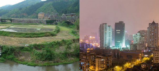

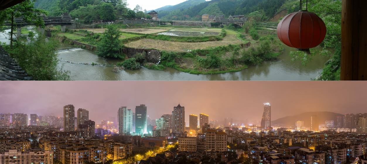
Efficient land use for urban development is crucial for limiting urban sprawl, conserving nature around a city, and improving the livability of the city itself. In China, the unprecedented speed of urbanization over the past three decades has unfortunately resulted in widespread inefficient land use, creating problems that only some cities are trying to solve today.
China is already home to the world’s largest urban population of 758 million, which is predicted to reach 1 billion by 2030. With an average of 15 million Chinese rural farmers becoming urban residents every year, there is no question that urban areas in China will continue to feed what may seem to be an insatiable appetite for land. How Chinese cities can satisfy the needs of a growing urban population while expanding sustainably is a critical question that affects so much of the Chinese landscape, from biodiversity to urban carbon emissions.
One of these issues is of particular concern to the central government—the dramatic loss of arable land.
Hungry for land
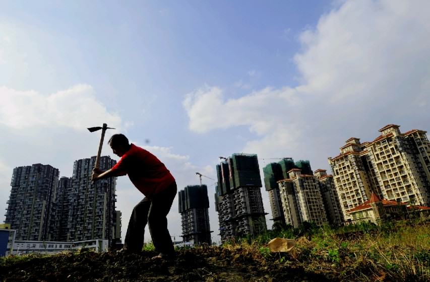
China has had an agriculture-based society for thousands of years, so cities and towns have usually sprung up among large swaths of farmland. Over time, urban expansion encroaches into more and more farmland, displacing farmers and reducing China’s total arable land. With a staggering 1.3-billion denizens, China’s arable land is already limited and extremely precious; its arable land per capita is only one tenth that of the US.
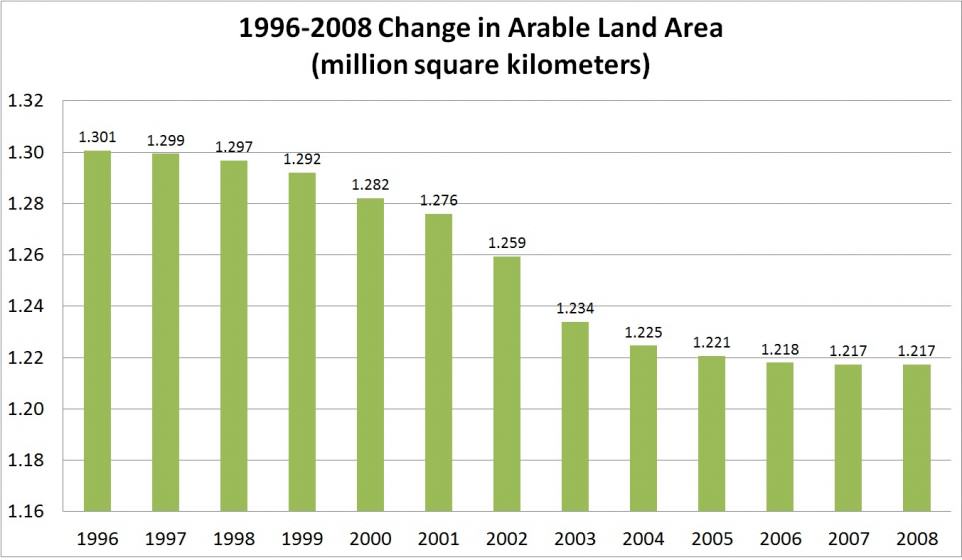
However, China’s inefficient land use has seen the nation’s total arable land area drop drastically, especially in recent years (see the figure below). The transition of large amounts of relatively lower-carbon-emitting agricultural land into urban areas has not only removed the carbon sink created by the original vegetation and soil, but has also enhanced carbon emission intensity largely due to construction of roads and buildings.
China now has 121 million hectares of arable land, only slightly higher than the central government’s target of 120 million hectares of protected farmland. Almost every city has enthusiasm for development of industrial parks, places with drastically lower building and population densities compared to old urban areas. Since 2006, the central government has started to designate economic development zones (EDZs) across the nation, with increasingly more rigorous control over the newer EDZs. However, demand for land remains overwhelming and inefficient land use is still prevalent for several reasons, including tax systems and government coordination issues.
Then there’s the complicated issue of carbon emissions. How land is used determines how much carbon is emitted, both during the rural-to-urban conversion process and through urban land use and transportation planning. Emissions generated from China’s farmland represented only 1.84% of China’s land-based carbon emissions in 2008, meaning that farms have a carbon emission intensity of only 3 tons/km2. Converting farmland into developed urban or industrial spaces drastically increases carbon emission intensity to 3,364 ton/km2 and 4,781 ton/km2, respectively (Lu 2011). Common disregard for long-term urban infrastructure planning creates another problem down the line. Roads and buildings built without considering long-term effects have made construction materials and long-term usage of built infrastructure, large sources of carbon emissions themselves. For example, while the construction process and materials required for making a wide road produce carbon emissions, the same road allows for more motorized vehicles to travel and thus generates even more carbon emissions.
Sources of the rapid decline in arable land and increase in carbon emissions from urbanization can often be linked with poor development management systems at different government levels and ministries. Until major reforms are effective, these worrying trends will likely remain unchanged.
The Chinese tax regime: a major culprit
When the central government divided its taxes into central and local collection in 1994, easily collected taxes from stable sources became central government taxes, while local taxes were left with taxes from scattered sources that were costly to collect and difficult to administer. As a result, tax revenues for local governments became, and still are, very limited. However, local governments were given the key to a hidden treasure chest—the authorization to convert rural collectively-owned land into urban land for development. This is a huge opportunity given the context that there is no private land ownership In China.
Rural land is owned collectively by local farmers, while urban lands belong to the nation. Local governments can authorize the use of a particular section of land in their jurisdictions. Local governments began to sell the land rights to developers in exchange for land concession revenues. Thus, local governments have been appropriating rural land for urban construction and then using the land concession revenues to address their own fiscal deficits. From 2001 to 2003, China’s land concession revenues amounted to a massive 910 billion RMB, or 35% of local revenues. In 2010, this figure rose to 69% of local revenues. In 2012, land concession revenues climbed to a whopping 2,690 billion RMB (Huang and Cai, 2013). With so much money to be made in rural to urban land conversion and not much to rely on for stable revenue, local governments had no incentive to develop land efficiently. In contrast, this system is largely responsible for the low-density and wasteful land use practices of the past three decades.
Fortunately, the National Audit Office recently launched a nationwide campaign targeting the finances and debts of local governments. Moreover, the politburo just passed the General Plan for Fiscal and Tax Reform. China’s minister of finance indicated that one objective of this reform is to create a tax regime that will level the playing field and unify the market environment, but the details of this plan have not been disclosed yet.
A dance of four ministries
Spatial planning coordination and the creation of a streamlined planning system are gradually gaining more attention in the eyes of the Chinese government. Unlike streamlined planning systems used in most Western countries, China’s spatial planning system is a confusing, “multi-regulation” parallel planning system between four central government ministries. Since the origins, objectives, methods, standards, and implementation periods, etc. of these different programs differ, the agencies get tied up with overlapping, contradictory, and even conflicting issues. This disorganization detracts from the effective allocation of resources and management, negatively affecting land use efficiency.
In August 2014, the four ministries jointly issued a notice calling for a “regulation merger” and selected 33 pilot cities. Prior to this, Tianjin, Shanghai, Chongqing, Guangdong, Beijing and other cities already performed a “regulation merger” trial run, gaining valuable and practical experience. Like the recent tax reform, we still have yet to see how effective this new “regulation merger” will be.
The shining stars
Despite the challenges, there are always some shining examples of progressive cities in China making the shift towards more efficient land use. In our work, we like to highlight these cities’ good practices to encourage other cities to follow their lead. Here are a few of our favorites:
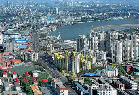
“Landless investment” in Shanghai:
A populous city with a limited carrying capacity, Shanghai is constrained by land availability. Since 2004, some districts have adopted the “landless investment” strategy to develop even where additional land was unavailable.
The goal: to renovate and transform industrial areas while improving the downtown economy and ushering in high rise buildings and the modern service industry.
To transform old industrial parks, investments were given to old companies with excess land to upgrade facilities and increase efficiency. Enterprises with low output per unit of land, high energy consumption, and high pollution emissions were shut down, freeing up land for new, more efficient enterprises. From 2004 to 2005, Shanghai removed 250 enterprises with high energy consumption, low output, and heavy pollution, resulting in 6,875 acres of freed land. The selection process that determined which enterprises could move into the industrial park involved a comprehensive assessment of industry orientation, environmental protection, land demand, and other indicators. Therefore, only enterprises with intensive land use were allowed to establish.
One of the industrial parks participating, Qingpu Industrial Park, developed regulations preventing new investments of less than $300 million/km from establishing, and now requires the expected output to be no less than 3 billion yuan/square kilometer. These regulations clearly define the minimum standards for building density and floor area ratio of land for each project. In Jiading district, 72 prospective projects were assessed, and 32 of the candidates were approved with the average investment per acre at $312,300. These investments across Shanghai’s participating industrial parks also promoted industrial upgrades, resulting in overall economic benefits. With Shanghai leading the way, the minimum capital intensity of land and land use efficiency of the entire Yangtze River Delta region increased.
Redesigning core areas of Chenggong, Kunming:
When Chenggong New Town began construction in 2003, the original plan was covered in superblocks and single land-use patterns, two of the most common yet inefficient urban development patterns in China. Much of the area became packed with buildings of similar appearances and functionality. Excessively wide superblock roads decreased pedestrian safety and bicycle accessibility. Thanks to noise and pollution issues from increased vehicle traffic on the road, buildings were being built further from the road, making pedestrians walk farther just to enter the buildings. These obstacles not only undermined street retail prices, but also reduced transit accessibility and livability of the Chenggong New Town. In 2011, the US Energy Foundation and MoHURD collaborated to launch an urban low-carbon development pilot project.
The goal: to redesign core areas of Chenggong New Town into a transit-oriented hub with mixed land use to create a low-carbon city.
By the time the pilot project was launched in 2011, the original Chenggong New Town plan was partially completed and many projects were under construction. The new plan therefore needed to cooperate with already constructed roads, existing sites, local culture and regulations. Superblocks were replaced by small-scale neighborhoods, which included a multi-functional blend of residential and other buildings. In addition, small-scale neighborhoods favor cycling and walking, reducing the demand for motorized vehicles and increasing the efficiency of buses and private cars. Starting from the transit-dense city center, comprehensive development of offices, retail, entertainment and residential areas have been developed within walking distance. Finally, mixed use neighborhoods encourage walking, which is beneficial for the local economy since walkable cities ultimately increase vitality of local businesses.
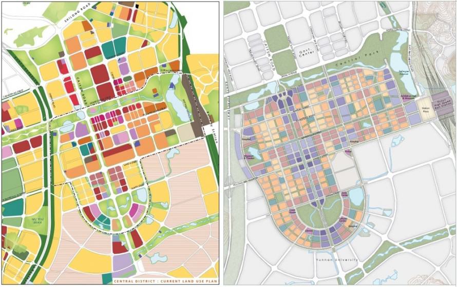
Chenggong’s core areas transformed from a network of superblocks into a compact grid of smaller neighborhoods. The new design, with a multi-modal transportation infrastructure, greatly improved land use efficiency and created a more convenient, user-friendly urban living environment. Environmental benefits expected from these results include reductions in vehicle emissions by 72%, greenhouse gas emissions by 59%, and total motor vehicle kilometers traveled by 67%.
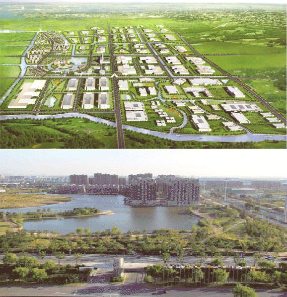
Integrated planning in Tianjin Binhai New Area:
In 1994, the Tianjin Municipal Government decided to build upon the foundation of the Tianjin Economic and Technological Development Zone and the Tianjin Free Trade Zone to create the Binhai New Area.
The goal: to develop Binhai New Area as a thriving economic hub and livable ecological city for residents.
Source: CNRadio.com
Binhai New Area’s success was largely due to its efficient and pragmatic planning and implementation system. First, Binhai New Area established a first-class unified planning system and a master plan with functional area planning, urban planning, and land use planning with a planning period of 20-50 years. The master plan stresses equal importance of environmental protection and urban planning within overall land planning. Secondly, it established unified technical standards for the planning system, which unified land size and standards, along with basic planning details (Wang, 2009). Third, the planning was implemented by the newly created Binhai New Area Administrative Committee for more efficient coordination between different departments. This new district administrative system was much more effective than the old systems were for working within this new model. The Binhai New Area has been wildly successful and has since become the gateway to northern China’s open development. Known as “China’s third economic growth pole”, it is now an advanced manufacturing and R&D hub, a northern international shipping and logistics center, and an ecological city for residents. Tianjin Binhai New Area’s integrated planning model has since become a template for other new district development to follow.
Moving forward
While there are some good examples of more sustainable land use in China, the reality is that the vast majority of Chinese cities are still struggling to use land efficiently, causing the rapid decrease in arable land while increasing carbon emissions. To make the cases of Shanghai, Chenggong New Town, and Binhai New Area more common, key steps that China should take include: 1) universalizing high-density land development; 2) adjusting tax policies to encourage land conservation and intensive utilization; and 3) promoting integrated and coordinated government administration on spatial planning.
The Chinese central government has already launched its fiscal and tax reform, and there is already coordination in efficient land use practices and spatial planning in several Chinese cities. However, China will still need to go above and beyond on a much larger scale and use more diversified methods to reduce its appetite for massive expansion and to develop sustainably for more low-carbon and livable cities.
Judy Li and Pengfei Xie
Beijing
Note: The content of this blog was extracted from “Climate Change and Urbanization: Challenges and Progress in China”, a report written by NRDC’s China Sustainable Cities Project. The report was endorsed and jointly released by the China Coalition on Urban Sustainability.
References
Lu, N.(2011). Research on Carbon Emission Effects of Land Use Change. Nanjing Agricultural University, Nanjing.
Huang, G. and Cai, J. (2013). Divided Taxation System as a Root Course for Land-based Local Government Revenue – Strategies for Correction 土地财政的分税制根源及其对策, Macroeconomics Research, June 2013.
Wang, CH. (2009). Discussion on Binhai New Area’s implementation of “Regulation Merge”. Port Economy. 2009(8):8-12.
About the Writer:
Judy Li
Judy Li is a Princeton-in-Asia fellow with NRDC Beijing’s China Sustainable Cities Program, focusing on low-carbon urbanization, smart growth planning, and urban sustainability. Her current work includes researching Chinese low-carbon urban development trends and examples, walkability and bikeability of Chinese cities, and sustainable urban waste management.


Hello,
I am a Master’s student of Politecnico di Milano in Building Engineering and Architecture.
I have been fascinated by your article and I am getting more and more interested in Urban Planning and land use in developing countries as China.
In particular, I would like to learn more about social problems due to high density of population and environmental problems related to land consumption, urbanization and industrial agriculture.
I have just been in Shanghai to join the workshop “Walking Luijazui” with the following universities:
-Tongji University of Shanghai
-Technische Universität of Wien
-Shenzhen University
-SouthEast University
The main purpose was to make the Central Businnes District of Luijazui more in a human scale, to solve the problems related to pedestrian and motorized mobility, and introduce multifunctional buildings in the area in order to guarantee the presence of people all the day long (I have noticed something similar in your article about the project Chenggong New Town).
Now I am starting my Master Thesis and the result of the workshop in Shanghai is going to be the beginning point for my graduation project.
In the future I would like to continue working in the field of the research and planning of sustainable cities.
I would like to ask you more information about your mission, some suggestion for the future, some material to read and contacts.
I would appreciate any suggestion, it could help me a lot since your article has been the only one, even after a long period of research, responding to my needs and interests.
My private contact: [email protected]
Thank you,
Best regards
Andrea Baraggia