

My interest in learning about the services that natural areas provide to the community begun after the earthquake that hit south-central Chile on February 27, 2010. Though no major infrastructure damage occurred, the earthquake, tsunami and countless aftershocks caused great fear in the population, who were in particular insecure to return to their homes. For this reason, the community gathered in the open space, including natural areas. As it has been recorded in other parts of the world (Link 1; Link 2; Link 3), the open space was mostly used for camping, refuge and as escape routes, while natural areas, both inside and outside the city limits, became a source of provisioning services such as water and firewood (for heating), and cultural services, for gathering, camping and the provision of urban supplies.
The various studies we have undertaken since 2010 have made us realize that the services provided by natural areas in particular, or ecosystem services, are context specific and are conditional to what people see in the landscape. Ecosystem services vary on one hand, on the physical attributes of natural systems, meaning their elements and organization, which in turn, affect their provisioning capacity, their appearance and the way people perceived them. On the other hand, ecosystem services vary with the socio-cultural aspects of a community, which influence the possibilities of people to value natural areas as useful for their specific needs at specific times. Our studies also support the idea that people’s perception of nature and their capacity to perceive potential uses after disaster depends on their knowledge and familiarity with the landscape. For instance, ecological knowledge can help to differentiate between water bodies useful for drinking, among others which are useful for washing only. Similarly, a high familiarity with the landscape can help discover services in natural areas, such as hidden recreational pathways in the forest, which can be much valued as evacuation routes after a tsunami.
For these reasons, not every park, hill and wetland among other natural sites, are used in the same way after disaster. Why does utility vary between sites? Are the uses of natural areas for daily life and for a post-disaster situation compatible? And most importantly for landscape professionals, can design and urban planning improve the role of natural systems after disaster?
Yes! By identifying the biophysical attributes that are perceived by people, understanding the manner in which they are organized, the services they provide, and the meanings (e.g. uses) they convey after disaster, we have useful information to make landscape interventions which are compatible with both, nature and people’s needs.
These questions motivate the research we have been carrying out since 2010 in different cities of Chile affected by earthquakes and tsunamis, with particular emphasis on the use and role of natural systems located both inside and outside the city limits (See link 4). We know that landscape properties are valued due to both, the services landscapes provide (provisioning, regulating, cultural and supporting services)(link 5) and to the capability of the people to see them. This idea has been widely explored and proved in other landscape types and urban areas, with a focus on the study of affordances, or the ‘useful things’ that people ‘see’ in the environment (Gibson, 1979; Heft, 2003). Affordances are not things themselves but are resources that arise between the interactions of the properties of the environment and of the perceiver (Chemero, 2003); hence, are available for people that are capable of perceiving and using them. Landscapes elements are typically valued because they are useful in some way at specific times, in relation to people’s abilities and in particular contexts.
The case studies I present next provide further insight in the context after disaster.
Structure affects use: camping versus water extraction
In the inland city of Concepción, urban lagoons, which are the remnants of ancient riverbeds, were used to collect water, and also for overnight stay, meeting and for gathering information after the earthquake of February 27, 2010 (Mw 8.8) (To see a full range of photographs that show the use of the open space after the earthquake in Concepción see Link 7).
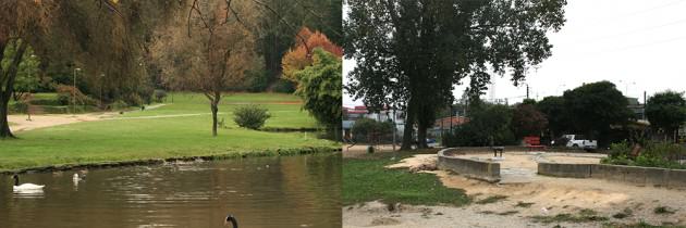
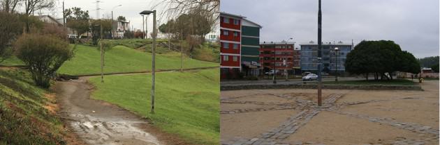
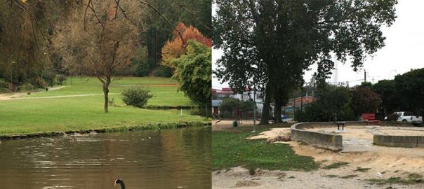
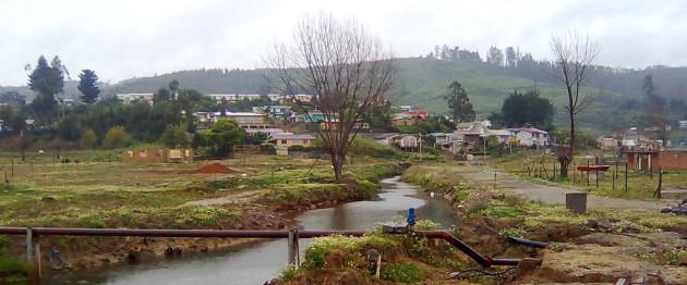
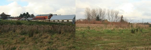
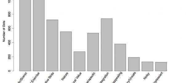
The urban wetlands of Concepción were our pilot study (Villagra et al., 2014; Villagra and Dobbie, accepted), which provided inspiring and highly suggesting information. It shed light on the role of urban wetlands to support everyday life and life in times of crisis, which is conditioned by the biophysical aspects of the wetlands. Aspects such as water visibility and the presence of pathways, fences and buildings are elements in the wetland areas that define landscape utility before and after disaster, and which, at the same time, can be manipulated by planning and design. The meadows (Figure 1) — or wetland areas close to water with different grasses and herbs, and which lack of excessive urban cues — were found to be useful for ‘observing nature’ before disaster, and for ‘water extraction’ after disaster. Other areas such as the uplands (Figure 3) — closer to urbanized environments and with a mix of paved and grass areas with trees and urban furniture — were described as for ‘playing’, ‘jogging’ and ‘walking’ before disaster, and for ‘camping’ and the provision of ‘goods and services’ and ‘security’ after disaster. The study of the use of urban wetlands in Concepción assured us that the use of nature in cities is conditioned by the structure of open spaces and it changes according to people’s needs.
Familiarity influences survival: escape and safety
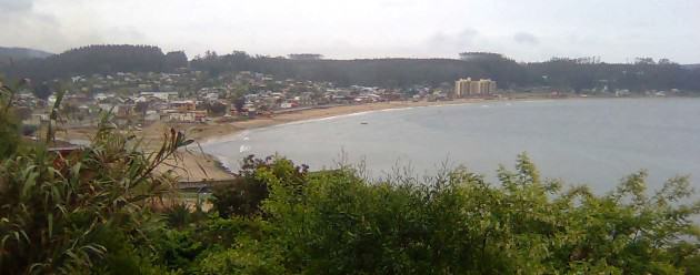
The case of the city of Dichato on the coast, revealed a different scenario and different service types. Dichato was affected by the tsunami after the 2010 earthquake, which flooded almost 100% of the urban area (Link 10). For this reason, the only place that was available to use post-tsunami was the hill, located outside the city limit and over 20 meters over sea level. Thanks to the familiarity of the local community with the streets that reach the highest points of the hill, were various ‘lookouts’ are placed, the streets were used as ‘evacuation routes’ and the lookouts as ‘safety zones’. These, in addition, were valued for providing visual information about the tsunami effects in the city. All type of electronic communication was disrupted after the tsunami; hence, being in an elevated area improved visibility, keeping the community informed. In the case of Dichato, the usual touristic and recreational activities provided by the hill — characterized by its elevated areas, the forest and the sea views — were transformed into survival activities, particularly for escaping and being safe. In this case, and in addition to the case of Concepción, the use of natural areas was also conditioned by the extreme effect of the disturbance on the urban space.
Time affects meaning: water resource versus waste dump
The case of the city of Valdivia, adds to the results from the Dichato and Concepción case studies. After the 1960 earthquake (Mw 9.5), changes in the landscape were so dramatic (see previous blog: Link 8), that changed the physical geography of the city. New wetlands were created in the periphery of the city, which used to be agricultural land, providing space for the development of ‘agriculture’ and ‘grazing’ activities, ensuring food for the community. After the earthquake, this land changed into a mix of dry and wet lands, providing ‘water’ as well as suitable areas for installing ‘temporary shelters’ to accommodate more than half of the population who lost their homes (35,000 people) (See link 9 for a photographic collection of the use of open space after the 1960 earthquake).
In addition, built up areas flooded by the river that crosses the city — formerly used as neighborhoods — were transformed into ‘escape routes’. People moved through these suburbs using boats available by most of the community before the earthquake, usually used to cross between both sides of the river. The case of the city of Valdivia after the earthquake of 1960 revealed that although the natural system was completely transformed by land use change (from agricultural land to wetland areas, and from urban areas to riverbeds), the natural system provided services for post-disaster recovery (Villagra, 2012). This can be explained because at the same time the physical geography changed, human needs were modified, and the transformed landscape provided the necessary services for survival.
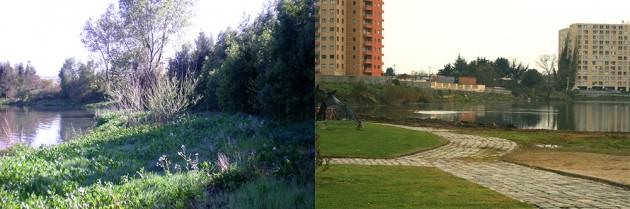
Knowing the spatial and temporal context in which the use of the natural system for post-disaster recovery unfolds, is very important, as it was revealed by the study we performed about the use of the same wetlands of Valdivia, but in 2012. Through a rigorous research process, we explored what would be the use people give to these wetland areas in a hypothetical earthquake situation nowadays, finding surprising results. The same wetland areas used for temporary housing and water extraction in the 1960, would be used today as places for the ‘disposal of debris and garbage”, regardless of the water they contain. This can be explained because of the change in the biophysical attributes that are visually appealing for the community. The beautiful landscapes of Valdivia’s wetlands in the 16th hundred, described as full of swans and herons (Guarda, 2009), has over time changed into a waste looking land, with overgrown vegetation, lack of urban public infrastructure and accessibility, which in turn has changed the meanings these wetlands convey.
In the same manner, the survival values assigned to wetland areas in the 1960s after the earthquake, are no longer embedded in the community’s perception of wetlands, unlike the case of Concepción, where the lagoons that provide daily recreation and depict evident cues of urban design intervention and management, were perceived as highly valued by the community after the earthquake. The value assigned to urban wetlands in Valdivia today, as a place for urban waste, most probably rely on their negative appearance as a result of mismanagement over the last 50 decades.
We know that natural systems provide invaluable provisioning, regulating, cultural and supporting services. Flood and climate control, urban water cleaning, biomass and atmospheric oxygen production, recreation, aesthetic experiences and wellbeing, are only few of the services provided by natural areas. However, it is important to highlight the role they take in the post-disaster context. There are ecosystem services that are not relevant during everyday life but this does not mean they are less important. Some services are dormant resources, which are activated only after a major disturbance; such is an earthquake or tsunami. The role of wetlands, dunes and mangroves to mitigate tsunamis and floods, as well as the role of vegetation communities with flora which is fire retardant are well documented in the literature (Chiang et al., 2014; Hoehn et al., 2003; Link 5; Walker and Salt, 2006) and used in the planning and design of urban environments. In the same manner, it is important to keep exploring and including in the planning and design of cities the role of nature to provide cultural and provisioning services at the local scales after disaster, such as those revealed in the cities of Concepción, Valdivia and Dichato.
Ecosystem services after disaster and at the local scale are affordances, conditioned by the interaction between the needs of the community after disaster, the possibilities of the natural system to satisfy such requirements, and the biophysical aspects that shape the utility of the space. Therefore, these services are rooted in a specific physical and cultural context, and not transferable from one community to another. Accordingly, the capacity of metamorphosis of the natural systems after disaster and of the values people assign to them, changing from their usual recreational and/or economic use to places that provide provisioning and cultural services, should be taken into consideration during the planning and design of cities. Different needs emerge in cities after disaster which can be satisfied by the use of natural systems within and between urban environments. As a consequence, the ‘nature of cities’ after disaster change, including physical landscape change and the way people perceive, use and afford it.
Paula Villagra
Los Rios
Links of interest
1. http://www.pennyallan.com/wp-content/uploads/2014/02/Resilience-as-a-framework.pdf
2. http://www.nat-hazards-earth-syst-sci-discuss.net/2/4263/2014/nhessd-2-4263-2014-print.pdf
3. http://www.unocha.org/top-stories/all-stories/nepal-preparing-earthquake-kathmandu-valley
5. http://www.unep.org/maweb/en/Index.aspx
6. http://www.jnd.org/dn.mss/affordances_and_design.html
7.http://prontus.diariosregionales.cl/prontus_sube/site/edic/base/port/aniversario_terremoto.html
10. http://www.dichatovive.cl/asi-quedo-dichato/
References
Chemero, A. (2003). An Outline of a Theory of Affordances. Ecological Psychology, 15(2), 181-195.
Chiang, L.-C., Lin, Y.-P., Huang, T., Schmeller, D. S., Verburg, P. H., Liu, Y.-L., et al. (2014). Simulation of ecosystem service responses to multiple disturbances from an earthquake and several typhoons. Landscape and Urban Planning, 122, 41-55.
Gibson, J. J. (1979). The ecological approach to visual perception. Boston: Houghton Mifflin.
Guarda, G. (2009). Cuatro Siglos de Evolución Urbana Valdivia 1552-1910. Valdivia: Universidad Austral de Chile.
Heft, H. (2003). Affordances, Dynamic Experience, and the Challenge of Reification. Ecological Psychology, 15(2), 149-180.
Hoehn, J. P., Lupi, F., & Kaplowitz, M. D. (2003). Untying a Lancastrian bundle: valuing ecosystems and ecosystem services for wetland mitigation. Journal of Environmental Management, 68, 263-272.
Villagra, P. (2012). Landscape change and urban resilience: the role of natural and urban landscapes in earthquake recovery of the city of Valdivia, Chile. Paper presented at the International Conference on Urban Sustainability and Resilience, London.
Villagra, P., & Dobbie, M. (Accepted). Design aspects of urban wetlands in an earthquake-prone environment. Journal of Urban Design.
Villagra, P., Rojas, C., Ohno, R., Xue, M., & Gómez, K. (2014). A GIS-base exploration of the relationships between open space systems and urban form for the adaptive capacity of cities after an earthquake: the cases of two Chilean cities. Applied Geography, 48, 64-78.
Walker, B., & Salt, D. (2006). Resilience thinking: sustaining ecosystems and people in a changing world. Washington: Island Press.

Leave a Reply