

Several months ago, the City of New Orleans was awarded $141 million dollars from the U.S. Department of Housing and Urban Development (or HUD) to implement a wide-ranging green infrastructure project in the city’s Gentilly neighborhood. The main goal of this project, known as the “Gentilly Resilience District,” is fairly straightforward: slow down soil subsidence and take pressure off of the city’s complex drainage system by retaining groundwater and capturing stormwater on the landscape during rain events.
A project in the Gentilly neighborhood of New Orleans aims to demonstrate how cities can adapt existing systems and utilize green infrastructures to deal with water challenges.
While limited in its spatial scope to one neighborhood, the project represents an ambitious move by local authorities to fundamentally upend long-held views on water management in the city. This essay describes the aims and scopes of the Gentilly project, and places the intervention in a longer historical context of the engineering strategies applied to the city’s peculiar deltaic geomorphology and ecology over the past century.
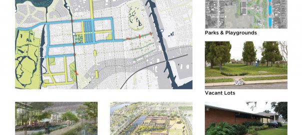
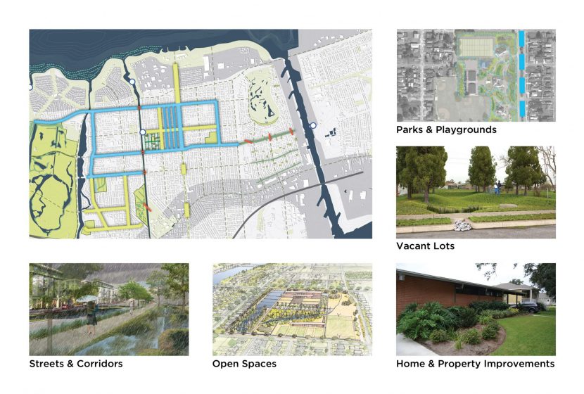
Announced in January 2016, the Gentilly Resilience District project aims to provide a concrete demonstration of how cities like New Orleans can adapt existing systems and utilize green infrastructures to deal with water challenges. The figure below shows the main interventions the project entails. Some of this work will “daylight” drainage canals that are presently sealed in concrete and buried in street medians. The idea here is transforming invisible gray infrastructure into green infrastructure with multiple public benefits: improving the quality of public green space, and giving the landscape the capacity to retain more surface and groundwater, while not exacerbating the flooding risk to neighbors.
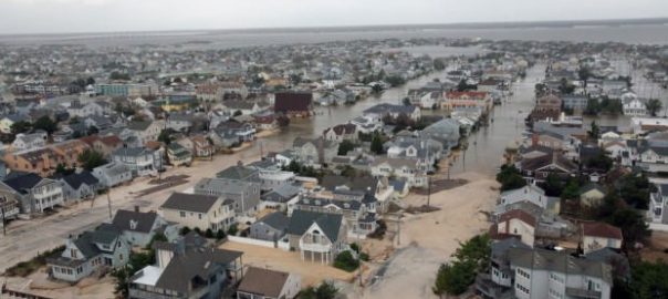
 New Orleans typically receives around 64 inches (162cm) of rain annually, and much of this volume arrives in the form of intense downpours that overwhelm the city’s drainage system, even with the marked improvements made since Katrina. The system can pump an inch of rain an hour in the first hour of a storm, and then a half an inch an hour afterwards. In other words, the system can handle three inches over a five-hour period. Often, localized downpours exceed this rate and water begins to collect.
This is where the other primary intervention of the project becomes relevant. Several large tracts of undeveloped land—a former sprawling convent that was destroyed in a fire after Katrina, and a remnant tract of bottomland forest near Dillard University—will capture and retain stormwater, storing it while neighborhoods and streets are pumped dry first. This video, produced for city agencies, provides a helpful illustration of how green infrastructure is being promoting as a “triple bottom line” solution to environmental problems in New Orleans.
https://www.youtube.com/watch?v=GMBdJQPk0pU
Before elaborating on the Gentilly project further, let’s return to the urban geomorphology of New Orleans, and explore the development of the problems the project aims to address. It’s no secret that much of New Orleans was constructed on drained swampland. City engineers devised a comprehensive drainage system around the turn of the 20th century with two central aims. First, they pumped dry the freshwater forests in the city’s low-lying basins, which was incredibly effective in mitigating the spread of diseases including yellow fever, malaria, and cholera. Prior to this intervention, in the 1800s, thousands of residents, many of them recent arrivals from Ireland and other impoverished European nations, succumbed to yellow fever during the summer months. The city garnered a reputation as a “necropolis” that was to be avoided in warmer months.
Beyond the humanitarian and public health crises these outbreaks represented, they also had serious implications for the city’s core economic engine: international trade through the Port of New Orleans. On the one hand, the city’s centrality in the trade networks of the Caribbean and its need for laborers rendered it vulnerable to the arrival of pathogens and un-acclimated hosts aboard ships. During the worst outbreaks, however, quarantine orders and outright bans on ships visiting the city undermined economic activity. City engineers and public health officials, pressured by local economic elites, decided to simply install canals and pumping stations capable of draining the city’s entire urban footprint, limiting breeding ground for the yellow fever (Aedes aegypti) and malaria (genus Anopheles) mosquitos, and providing better elimination of sewage (cholera and dysentery threatened even native residents, who had acquired immunity to yellow fever). Between 1900 and 1920, deaths from yellow fever, malaria, and cholera plummeted, and life expectancy for New Orleans residents increased by over 20 years (NOS&WB, 1921). In a span of 20 years, diseases that previously paralyzed the city for several months out of the year were all but eliminated. This was a huge achievement that stabilized the city’s position in economic exchange networks and alleviated human suffering on an impressive scale.
Draining these swampy basins in the city had an additional effect: it opened up hundreds of square kilometers to urban development. Since the city’s founding in 1718, urbanization was largely limited to the natural levees along the Mississippi River’s banks, as well as a few narrow ridges (ancient river channels) that crisscrossed lands that were otherwise at or slightly above sea level. The city’s population (280,000 in 1900) was packed into dense urban neighborhoods along these ridges and riverbanks. Modern drainage (begun ca. 1900) de-coupled the city’s urban form from these constraints, and the newly drained basins (or polders) were subsequently developed, with medium to low-density residential housing as the dominant land use.
This draining and development process generated several problems, both immediate and in the longer term. The massive drainage pumps did more than just convey stormwater into local estuaries—the groundwater was actually removed as well, lowering the city’s water table substantially. The highly organic and peaty soils in these former swamplands were incredibly prone to subsidence, and sink they did, up to three meters or more in some places. Much of this subsidence occurred in the first few decades after the drainage system was implemented, posing challenges for the installation of roads, sewer lines, building foundations, and so forth. This underscores the essential paradox of hydraulic drainage in these organic deltaic soils: the more water that is removed from the soil, the more the land sinks, but the more the land sinks, the less drainage is assisted by gravity, and the more energy intensive and technically challenging removing that water then becomes.
This ecological reality was further complicated by a perverse incentive: as more people moved into these highly modified drained polders, residents demanded even more intensive drainage. This paradox involves trading one temporal pattern of ecological disturbance for another. Everyday rainstorms no longer led to major street flooding and standing water, but especially intense rainstorms could have dramatic effects on residents and infrastructure, as the bowl-like topography the drainage system helped to create filled with water. It could take days to fully drain against gravity.
The Gentilly neighborhood typifies this historical sequence and set of environmental, technological, and political factors. It is situated between a narrow ridgeline that bears its name (Gentilly Ridge) to the south, a deepwater navigation canal to the east (the Industrial Canal), and Lake Pontchartrain to the north (figure 1). Nearly every drop of rain that falls in the neighborhood must make its way into drainage culverts, through a series of massive pumping stations, and finally into Lake Pontchartrain. In some cases, stormwater must be mechanically elevated 2-3 meters before reaching the lake, which is more or less at sea level. By retaining more water on the landscape, planners in New Orleans are hoping that green infrastructure can be part of the answer in ensuring the city’s long-term sustainability in the face of rising seas and more intense storms.
Since Hurricane Katrina in 2005, hundreds of experts in the fields of water management, civil engineering, urban planning, and ecological design have helped develop proposals for re-thinking and adapting the city’s approach to water. Local architect David Waggoner has been at the forefront of this by convening collaborative planning processes that draw upon international best practices for dealing with urbanization in the context of river deltas. These insights were subsequently elaborated into the “urban water plan,” a vision for adapting the city’s water systems. Building upon these initiatives, the city of New Orleans was selected by the Rockefeller Foundation as one of its first “100 Resilient Cities” program. New Orleans was the first among these cities to develop its “Resilience Strategy,” a plan completed in 2015 that drew heavily upon the afore-mentioned work on water management. With the funding from HUD awarded for the Gentilly Resilience District in 2016, these post-Katrina planning initiatives are now finally on the cusp of being implemented at a neighborhood scale.
With funding for green infrastructure finally coming down the pipeline, how will the Gentilly project achieve its multiple goals of improving groundwater retention, mitigating flood risk, and improving community green spaces? Even though the project is limited to a single neighborhood, the initiative has multiple sites and interventions. Let’s focus one of the project’s signature sites. The Mirabeau Water garden is a 25-acre (.10km2) empty tract of land in the heart of the Gentilly neighborhood. Formerly, the site was home to a sprawling convent, which was gutted by a fire in 2006, a year after it was inundated by floodwaters following Katrina.
The property, now controlled by the city government, will be re-engineered as a catchment for stormwater and a public green space. Stormwater from nearby streets will be conveyed into wetland basins, or terraces, along a long swath of the property. This water is thus removed, at least temporarily, from the city’s drainage systems, adding capacity to the system during heavy rainfall events. Vegetative plantings are planned throughout the Mirabeau site to help filter the captured water, provide habitat for wildlife, and beautify the site for visitors (see figure 1).
Similar interventions are planned at a large remnant forest tract nearby, at an even larger scale. With assistance from local urban ecologists, ecological monitoring will be conducted on all the project’s sites, to track how alterations in the area’s hydrology impact plants, rodents, birds, and insects. In the subtropical and swampy environment of South Louisiana, environmental management is a critical aspect of urban public health. While green infrastructure interventions aim to mitigate flood risks and improve urban green space for city-dwellers, the prospect of a project that involves large basins of standing water give rise to concerns over nuisance species like mosquitos and rodents. This has become especially poignant in the summer of 2016, as Miami deals with a Zika outbreak in the heart of the city.
The Zika outbreak underscores a certain paradox with green infrastructure in New Orleans, and emphasizes the importance of careful monitoring and adaptive management of such projects. The city’s unified drainage system generated massive improvements in urban public health in the early 20th century. But the unintended effects of that same system are now threatening the very habitability of the city in the face of rising seas and intense storms. Open canals, bioswales, and constructed wetlands might prove effective in reducing subsidence and adding capacity to the city’s drainage system during storms. At the same time, these projects will, to some degree, replicate eco-hydrological conditions that prevailed in the city before 1900, though on a small scale. As such, the Gentilly project will have to wrangle with all of the ecological ramifications of these interventions, even the undesirable ones. City leaders understand this challenge, and are confident that New Orleans does not have to choose between a terra-formed and vulnerable bowl, and a mushy swampland full of disease vectors, such as mosquitos.
In subsequent posts, I hope to document the implementation of the Gentilly Resilience District project, exploring how the project reshapes water, ecosystems, and communities. If the project manages to achieve the suite of benefits it is aiming for, a strong argument could be made for implementing similar projects throughout New Orleans. The widespread implementation of these measures could help the entire city balance wet and dry conditions, and to be much better positioned to cope with the impacts of climate change.
Josh Lewis
New Orleans

Leave a Reply