

(Nota: A versão em Português segue imediatamente.)
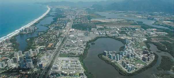
The tropical urban landscapes of Rio de Janeiro, a city of 6.3 million inhabitants, are really impressive and unique. It is the outcome of five centuries of nature-human interaction. Last week UNESCO elected part of the city as a World Cultural Heritage.
It is quite meaningful that most of the selected images show the high biodiversity Atlantic Rainforest that have regenerated after centuries of natural resources exploitation and agricultural practices that had eliminated most of the native land cover (http://whc.unesco.org/en/list/1100/ viewed 07.05.2012). Actually the forests are fragmented, surrounded by dense urban occupation, and under pressure of further expansion repeating the same mistakes made in the past. The urbanized areas occupy mainly the lowlands, where ocean lagoons and wetlands were land filled with the devastation of several hills. One of the elected sites, the Flamengo Park, is a huge 1.2 km² created land, where the world renowned landscape designer Roberto Burle Marx was responsible for the magnificent gardens.

In the Tijuca massif, where the famous Christ the Redeemer oversees the city, coffee plantations replaced forests and then were abandoned leaving a grassy and dry landscape until the XIX Century, when their slopes were partially replanted to restore the water sources. Nature took care of the rest, with the regeneration of vast areas of the two major massifs: Tijuca and Pedra Branca. Both are protected areas today. Tijuca National Park is one of the UNESCO elected sites. In the last 25 years a successful city reforestation program called “Mutirão Reflorestamento” (“common effort to restore forests”) has effectively replanted trees on slopes to prevent landslides, mainly close to the favelas. It is a social-ecological program because local people are hired and trained to work in the planting and monitoring process, becoming stewards of the forest.

Green Yields to Grey
Although nature is present in our scenic views, the urbanized areas are heavily impervious and gray, especially in the Northern zones with almost no remaining green areas, not even public squares. The city has diverse environments, with pleasant forests and nice parks contrasting with arid, hot and noisy streets where the majority of the population lives. Most of the time the city is fairly hot. For instance, today is winter and the temperature is 29°C (84.2°F) at mid-day. I live very close to the forest, where it is quite pleasant with many trees, birds and insects. Native and invasive species are present, and should be permanently managed. Biodiversity abounds even close to the ecosystem remnants. In fact, if we let the windows open in the morning, monkeys (Cebus apella) come inside our apartment. Many residents feed them, consequently they keep coming back after easy junk food. Meanwhile, if I walk down one block, the traffic jam is constant, the temperature is much higher, and the street trees are old, under severe pressure in unsuitable situations, and many are dying and not being replaced.

People value the forested hills and the beaches mainly for recreation, biking, walking, hiking or just contemplating. I am not sure how they acknowledge and value the ecosystems services the forests and the urban trees provide. There is a great opportunity for further research about urban ecology and urban/regional landscape planning in Brazil, but there still isn’t formal education in these fields. Urban biodiversity and human-nature relations are not current issues in the majority of the Brazilian cities either, where in the last 20 years shopping malls and manicured gardens of gated communities are replacing open public spaces as recreation areas.
Urban Nature is not a Rio de Janeiro Decision-maker’s Priority
The decision makers in Rio de Janeiro do not make urban nature a priority. There is a lack of real comprehension of the role of biodiversity for a healthy city. The urbanized areas are subject to frequent floods and landslides because of the historic change in land use and vegetation cover. The World Cup and Olympic games that will take place here in the coming years drive a fast urban expansion that follows the same land cover pattern transformation in the remaining lowlands located in the western zone, in the Jacarepaguá and Guaratiba watersheds. Wetlands are being filled to create land for new expressways (cars and BRT’s) and by the real estate speculative process. The last legally protected mangrove remnant is under threat of excessive salinization because a new highway was built with traditional engineering techniques that interfere with the hydrologic flows, block the fresh water in the residential side, and, according to residents, cause more severe and recurrent floods. Other roads are under construction with no care for the landscape ecological processes and flows, eliminating biodiversity and changing water flows.

Planning for Green Corridors
On the other hand, the City’s Environmental Department is working on a new Green Corridors plan to reconnect fragmented forested patches and to try to contain irreversible ecological damages in the urban expansion areas. Celso Junius, the head of the Mosaico Carioca, together with 20 specialists from 8 city departments constituted the working group that developed the initial proposition for the Green Corridors (available at http://mosaico-carioca.blogspot.com.br/search?updated-max=2012-05-23T22:41:00-03:00&max-results=3). The Environmental Department has done a great job of mapping all the Atlantic Rainforest ecosystems fragments and making it available on line ( http://sigfloresta.rio.rj.gov.br/ viewed 07.05.2012). “Sigfloresta” mapping is an important tool to effectively monitor the land cover in real time and is being used to develop the Green Corridors plan.

Design that Mimics Nature in the City
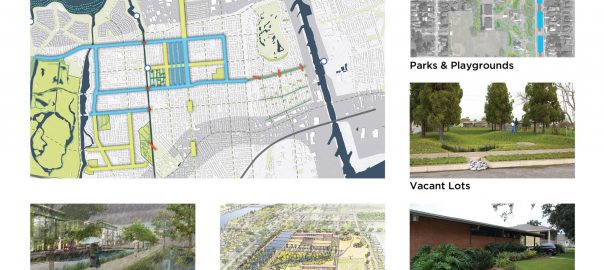
INVERDE is collaborating, on a voluntary basis, to further develop the green infrastructure plan, focusing first on the Jacarepaguá watershed, where the construction of many of the Olympic venues is driving urban expansion with high impact on the ecological landscape. The watershed is vulnerable to sea level rise, with most of its area no more than 1 meter above sea level. The wetlands and the low areas are being landfilled and rivers are being rectified and channelized.
Pierre Martin, a French landscape architect (partner of Embya studio located in Rio), and I are committed to helping improve the final report for the “Olympic Green Corridors”, which will link fragments of Tijuca and Pedra Branca massifs through the Jacarepaguá lowlands. The objective is to deepen and illustrate the proposals at the watershed and the site scale for a better understanding of the huge opportunities there are to shift to a new paradigm of social-ecological multifunctional and high performance urban landscape planning and design that mimics nature in the city.

We also believe that education and raising public awareness is vital to gain support for the proposition. We coordinated and recorded an open lecture at INVERDE in May 2012, which will be available on Youtube soon. We also co-organized a seminar with the City Environmental Department and the Botanic Garden Research Institute during the Rio+20 congress. It was an official event that focused on specialists and scientists working together to enhance the plan with a scientific foundation.We are all committed to taking this plan further on a continuous basis, with more research on urban ecology to better understand the abiotic and biotic processes and flows, as well as social-ecological relationships.The idea is not to greenwash the urban expansion, but to shift to a new transdisciplinary planning process and to design methods that incorporate science-based social-ecological knowledge.


Fernando Chacel
There are already local examples of ecological restorations that were designed by Fernando Chacel, a pioneer landscape architect with a systemic vision. He planned and designed state-of-the-art parks along the lagoons of Jacarepaguá, the urban expansion lowlands where Rio+20 took place. He started the designed restoration of the lagoons riparian corridors in 1980’s until he fell sick in 2009 (unfortunately he passed away last year). He recomposed degraded landscapes, beautifully reintroducing native ecosystems and respecting the phytosociology. He worked with a multidisciplinary team.

His legacy must be known, and therefore serve as inspiration to new professionals: he developed the “ecogenesis” theory, where he learned from nature to restore degraded mangrove, sandbank and wet forests. His book Landscape Architecture and Ecogenesis should be available in all Brazilian schools (it is in Portuguese and English).

Rio de Janeiro’s Green Potential
Rio de Janeiro has an enormous potential to be one of the greenest cities in the world, not only in GHG emissions mitigation or garbage collection and disposal (main targets of this administration).
The urban scale green infrastructure is outstanding and should be preserved and enhanced through the connection of the forest remnants, so they can exchange genetic faunal and floral material, in addition to providing clean human mobility for pedestrians and bicycles.
It is urgent that our decision makers have a real understanding of the role of urban biodiversity for healthy, safe, sustainable and resilient communities. Urban nature may offer numerous ecosystems services where people live, work and play: along the streets, in renaturalized canals, in roofs and yards, and in high performance, designed parks and squares with dense plantings of native trees.
********
Conectando as Magníficas Paisagens do Rio de Janeiro
As paisagens da cidade do Rio de Janeiro, uma cidade com 6, 3 milhões de habitantes, são realmente impressionantes e únicas. É o resultado de cinco séculos de interações entre o homem e a natureza. Na semana passada a UNESCO elegeu parte da cidade como Patrimônio Cultural da Mundial.
É muito significativo que a maioria das imagens premiadas tenha os maciços cobertos por Mata Atlântica com alta biodiversidade que se regenerou dos impactos causados por séculos de exploração de recursos naturais e de práticas de agricultura que tinham eliminado a cobertura vegetal nativa (http://whc.unesco.org/en/list/1100/ visitado em 07.05.2012). Na verdade as florestas estão fragmentadas, cercadas por densa ocupação urbana e sob pressão de expansão que repete os mesmo enganos feitos no passado. As áreas urbanizadas ocupam prioritariamente as terras mais baixas, onde lagoas oceânicas e brejos foram aterrados com o desmonte de muitos morros. O Parque do Flamengo (um dos locais eleitos) é um enorme aterro com 1,2 Km², onde o paisagista Roberto Burle Marx, reconhecido mundialmente, foi o responsável pelos magníficos jardins.
No maciço da Tijuca, onde se situa o Cristo Redentor que olha sobre a cidade, plantações de café substituíram as florestas e depois foram abandonadas deixando uma paisagem seca coberta por gramíneas. No século XIX suas encostas foram parcialmente replantadas para restaurar as fontes de água, com a regeneração natural que ocorreu em vastas áreas dos dois maiores maciços da cidade: Tijuca e Pedra Branca. Ambos se tornaram áreas protegidas. O Parque Nacional da Tijuca é um dos locais eleitos pela UNESCO. Nos últimos 25 anos, o bem sucedido programa da Secretaria do Meio Ambiente “Mutirão Reflorestamento”, efetivamente replantou árvores com intuito de conter deslizamentos, muitos próximos a favelas. Trata-se de um programa sócio-ecológico porque emprega e capacita moradores das comunidades locais para o plantio e monitoramente, que acabam se tornando guardiões da floresta.
O Verde se Submete ao Cinza
Apesar da natureza estar quase sempre presente em nossas belas vistas, as áreas urbanizadas são altamente impermeáveis e cinzas, especialmente na Zona Norte onde não há quase nenhum remanescente de área verde, nem mesmo praças públicas. A cidade tem ambientes extremamente diversificados, com florestas luxuriantes e belos parques contrastando com ruas áridas, quentes e barulhentas onde a maioria da população vive. A maior parte do tempo faz muito calor. Por exemplo, hoje é inverno e a temperatura no meio do dia é de 29°C. Moro perto da floresta, onde é bastante agradável com muitas árvores, pássaros e insetos. Espécies nativas e exóticas invasoras estão presentes e deveriam ser permanentemente manejadas. A biodiversidade abunda especialmente perto dos remanescentes dos ecossistemas florestais. Na verdade, se deixar as janelas abertas de manhã macacos-prego (Cebus apella) entram no meu apartamento. Muitos moradores os alimentam, portanto retornam atrás de comida fácil e não apropriada para eles. Ao mesmo tempo, se eu descer um quarteirão, o engarrafamento é constante, as temperaturas são mais elevadas e as árvores das ruas estão velhas, sob intensa pressão em situações inadequadas, muitas estão morrendo e não estão sendo repostas.
As pessoas valorizam os morros com as florestas e as praias principalmente para recreação, para caminhar, andar de bicicleta ou apenas para contemplar. Não estou certa de como reconhecem e valorizam os serviços ecossistêmicos (ou ambientais, como são mais conhecidos) prestados pelas florestas e pelas árvores urbanas. Existe uma enorme oportunidade para pesquisar sobre ecologia urbana no Brasil, mas ainda há não educação formal nos campos de ecologia urbana e planejamento urbano/regional da paisagem. Biodiversidade urbana e as relações pessoas-natureza também ainda não são preocupações presentes na maioria das cidades brasileira, onde nos últimos 20 anos shopping centers e jardins cosméticos com tendências globalizadas localizados em condomínios fechados têm se tornado as áreas de lazer de grande parte das cidades, substituindo os espaços públicos abertos onde o encontro com diversidade social acontece.
Natureza Urbana não é uma prioridade para os tomadores de decisão do Rio de Janeiro
Para os tomadores de decisões do Rio de Janeiro a natureza urbana não é uma prioridade. Existe uma falta de compreensão do papel da biodiversidade para a qualidade de vida em uma cidade saudável. As áreas urbanizadas estão sujeitas a enchentes e deslizamentos devido às mudanças históricas do uso do solo e da cobertura vegetal. A Copa do Mundo e os Jogos Olímpicos irão ocorrer nos próximos anos e estão levando a uma rápida expansão urbana que segue os mesmos padrões de transformação dos remanescentes de áreas alagáveis localizados nas baixadas de Jacarepaguá e Guaratiba. Áreas alagadas estão sendo aterradas para dar lugar a estradas (para carros e BRT’s) e para o processo especulativo do mercado imobiliário. O último remanescente de manguezal legalmente protegido (Reserva Biológica de Guaratiba) está sob ameaça de desaparecer pelo excesso de salinidade, devido à nova estrada que foi construída com técnicas tradicionais de engenharia que interferem nos fluxos hidrológicos, que estão causando enchentes mais freqüentes e recorrentes nas áreas residenciais do outro lado da estrada, segundo seus moradores. Outras estradas estão sendo projetadas e construídas sem o devido entendimento da ecologia das paisagens, e seus processos e fluxos, com a eliminação da biodiversidade e alteração na dinâmica das águas.
Planejando Corredores Verdes
Por outro lado a Secretaria do Meio Ambiente da Cidade (SMAC) está trabalhando em um novo plano de Corredores Verdes para reconectar os fragmentos florestais e tentar conter danos ecológicos irreversíveis nas áreas de expansão urbana. Celso Junius, coordenador do Mosaico Carioca, junto com 20 especialista de 8 departamentos da cidade constituíram um Grupo de Trabalho que desenvolveu a proposta inicial para os Corredores Verdes (disponível em http://mosaico-carioca.blogspot.com.br/search?updated-max=2012-05-23T22:41:00-03:00&max-results=3). A Secretaria do Meio Ambiente fez um excelente trabalho com o mapeamento dos remanescentes de ecossistemas de Mata Atlântica da cidade e de disponibilizá-los amplamente na internet, onde é possível emitir relatórios de acordo com os diversos interesses ( http://sigfloresta.rio.rj.gov.br/ viewed 07.05.2012). O “Sigfloresta” é uma ferramenta importante para monitorar de forma efetiva a cobertura vegetal e está sendo usada para desenvolver o plano dos Corredores Verdes.
Projeto que Mimetiza a Natureza nas Cidades
O INVERDE está colaborando de forma voluntária, para desenvolver mais detalhadamente o plano de infraestrutura verde, focando inicialmente na baixada de Jacarepaguá. A bacia hidrográfica local é vulnerável à elevação do nível do mar, com a maior parte de suas áreas não tendo mais do que 1 metro acima do nível do mar atual. As áreas alagáveis e as áreas baixas estão sendo aterradas e os seus rios e córregos retificados e canalizados pelo sistema de macrodrenagem, que também é do século XX, quando se tinha a pretensão de controlar as forças da natureza.
Pierre Martin, paisagista formado na França (sócio do escritório Embya ) e eu estamos comprometidos a contribuir para incrementar o relatório final dos “Corredores Verdes Olímpicos”, os quais irão conectar os fragmentos protegidos pelos maciços da Pedra Branca e da Tijuca através da Baixada de Jacarepaguá. O objetivo é aprofundar e ilustrar as propostas na escala da bacia hidrográfica e local para uma melhor compreensão do imenso potencial que existe ao se mudar para o novo paradigma sócio-ecológico que mimetiza a natureza na cidade, e de planejar a paisagem urbana para que tenha alto desempenho em diversas funções: para as águas, a biodiversidade e as pessoas.
Nós do INVERDE, também acreditamos que educação e conscientização das pessoas é fundamental para que possamos obter suporte para a proposta. Nós promovemos e gravamos uma palestra aberta ao público de maio de 2012, a qual em breve estará disponível no Youtube. Nós também coorganizamos um seminário com a Secretaria do Meio Ambiente da Cidade e o Instituto de Pesquisas do Jardim Botânico do Rio de Janeiro durante a Rio+20. Foi um evento oficial focado em especialistas e cientistas para trabalhar em conjunto para aprimorar o plano com base em ciência. Estamos todos comprometidos a dar andamento a esse plano de forma contínua, com mais pesquisas em ecologia urbana para melhor compreender os processos e fluxos abióticos e bióticos, bem como as relações sócio-ecológicas. A idéia não é fazer uma “maquiagem verde” (greenwashing) para a expansão urbana, mas mudar para um novo processo de planejamento transdisciplinar e para desenvolver métodos de projeto que incorporem conhecimentos científicos sócio-ecológicos.
Fernando Chacel
Existem exemplos locais de restauração ecológica que foram projetados por Fernando Chacel, o paisagista pioneiro com uma visão sistêmica. Ele planejou e projetou parques “estado-da-arte” ao longo das lagoas de Jacarepaguá, a baixada que sofre pressão de expansão urbana onde se localizou a Rio+20. Ele começou a projetar a recuperação dos corredores marginais das lagoas na década de 1980 até ficar doente em 2009 (infelizmente, faleceu no ano passado). Ele recompôs paisagens degradadas, reintroduzindo com grande beleza ecossistemas nativos e respeitando a sua fitosociologia. Ele trabalhou com equipes multidisciplinares.
Seu legado deve ser reconhecido e servir de inspiração para os novos profissionais: ele desenvolveu a teoria da “ecogênese”, onde foi aprender com a natureza para restaurar e proteger os manguezais, restingas e florestas paludosas de baixada. Seu livro “Landscape Architecture and Ecogenesis” deveria estar disponível em todas as escolas brasileiras que ensinam sobre o tema.
O Potencial Verde do Rio de Janeiro
O Rio de Janeiro tem um enorme potencial para ser uma das cidades mais verdes do mundo, não apenas em mitigação de gases efeito estufa e em coleta e disposição de resíduos sólidos (dois alvos prioritários dessa administração).
A infraestrutura verde na escala urbana é espetacular e deveria ser preservada e aprimorada através da conexão dos remanescentes florestais, para que possam fazer a troca de material genético de fauna e flora, além de oferecer mobilidade multimodal, sistêmica, limpa, confortável e segura para as pessoas, principalmente para pedestres e bicicletas.
É urgente que os tomadores de decisões tenham uma real compreensão do papel da biodiversidade urbana para comunidades saudáveis, seguras, sustentáveis e resilientes. A natureza urbana pode oferecer inúmeros serviços ecossistêmicos onde as pessoas vivem, trabalham e se divertem: ao longo das ruas, em canais renaturalizados, em tetos e quintais, em parques e praças projetados para ter alto desempenho sócio-ecológico com plantio intensivo de árvores nativas (não palmeiras!).
Leave a Reply