

about the writer
John Hartig
Dr. John Hartig is a Visiting Scholar at the Great Lakes Institute for Environmental Research at the University of Windsor where he is undertaking interdisciplinary research on the cleanup, restoration, and revitalization of the most polluted areas of the Great Lakes.
about the writer
Jessica Lienhardt
Jessica Lienhardt is the Great Lakes program director for the Council of State Governments’ Midwest. In this position, she guides the many activities and services provided to state and provincial legislators through the Great Lakes-St. Lawrence Legislative Caucus (GLLC) — a binational, nonpartisan organization of state and provincial legislators working together to protect the Great Lakes basin. Jess attained her master’s degree in public policy from Michigan State University and holds bachelor’s degrees in political science and history from the University of Michigan-Dearborn.
about the writer
Chris Morgan
Chris is a planner interested in parks and trails, land use planning, and geographic information systems (GIS). He works for the National Park Service’s Rivers, Trails & Conservation Assistance program as a Community Planner, partnering with local governments, nonprofits, and Indigenous Nations to support locally led conservation and outdoor recreation projects.
about the writer
Patrick Lydon
Patrick Lydon is a Landscape Architect with the National Park Service’s Rivers, Trails & Conservation Assistance Program. His work throughout the Midwest focuses on habitat restoration and conservation, public park spaces, and recreation facilities. He is committed to creating inclusive, functional, and sustainable outdoor spaces that enrich communities and create opportunities for people to connect to nature and wild places.
about the writer
Drew Hanson
Drew is a Partnerships Liaison for the State Parks program at the Wisconsin Department of Natural Resources. Trained as a Geographer, his career has included positions in government, academia, non-profit and private sectors. He focuses on land conservation and sustainable trails of the Upper Great Lakes.
about the writer
Marlaine Koehler
Marlaine Koehler is the Executive Director of the Waterfront Regeneration Trust. She has spent the past 30 years developing and leading the innovative partnership regenerating the Great Lakes waterfront through the creation of the spectacular Great Lakes Waterfront Trail. Under her leadership, the Trust has garnered significant public/ private investment in the waterfront and brought together an innovative and active community partnership of 177 communities, First Nations, and NGOs. Together, the Trust and its partners are leading a movement to regenerate and revitalize Canada’s Great Lakes.
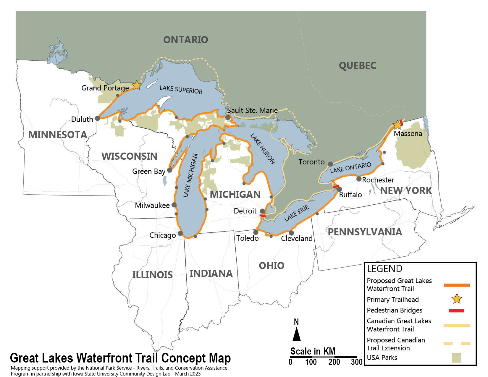
A binational Great Lakes Waterfront Trail will catalyze cross-border trail tourism, celebrate shared history and culture, promote conservation and outdoor recreation, and strengthen relationships between countries that share the longest border in the world.
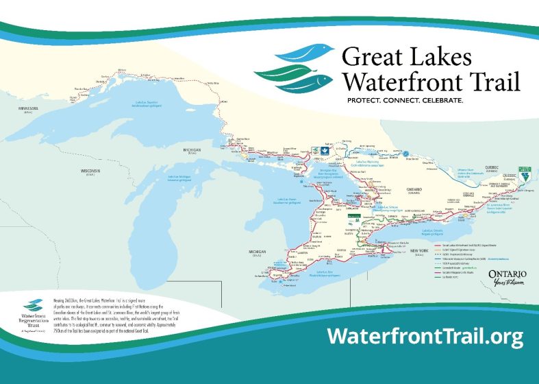
Celebrated for its breathtaking scenery, cultural richness, and recreational opportunities, Canada’s Great Lakes Waterfront Trail stretches along more than 2,250 miles of freshwater coastline and connects more than 170 communities and First Nations. Its goal is to reconnect people to one-fifth of the Earth’s standing freshwater and to each other, catalyzing improvements in many of the communities it joins. The eight Great Lakes states are now exploring a similar trail on the U.S. side. Both trails will be connected at border crossings, offering unparalleled cross-border trail tourism experiences for cyclists and outdoor adventure seekers alike.
The story of creating a binational Great Lakes Waterfront Trail is best told in three interrelated chapters that build upon each other.
Chapter 1: Canada’s Great Lakes Waterfront Trail
The Great Lakes Waterfront Trail is the signature project of the Waterfront Regeneration Trust, established in 1992 to succeed the Royal Commission on the Future of the Toronto Waterfront. Chaired by former Toronto mayor and Canadian Member of Parliament David Crombie, the Commission issued 83 groundbreaking recommendations in its final report, resulting in significant changes to waterfront and watershed planning.
One of those recommendations called for creating a waterfront trail that would serve as the foundation for a strategy to regenerate the waterfront. David Crombie evolved the Trust into a registered charity in 1999. It has worked for more than three decades to redefine people’s relationship with the Great Lakes and St. Lawrence River, and serve as a catalyst for ecological restoration, economic renewal, and cultural connection.
The Trail initiative is a partnership of 177 communities along the Ontario Great Lakes and St. Lawrence River waterfronts, collaborating to create a complete and connected trail system that is an integral part of each ecosystem it passes through.
The long-term goal is a dedicated trail as close to the water’s edge as ecologically feasible. Today, 13% of this 2,250-mile signed route is dedicated paths and quiet residential streets, 76% is on secondary roads, often in rural and northern regions, and 11% is on provincial highways with enhanced shoulders. It connects all four of Canada’s Great Lakes, five binational rivers, four UNESCO Biosphere Reserves, 68 national and provincial parks, 538 community parks, 266 beaches, and 106 protected natural areas.
The Great Lakes Waterfront Trail uses interim routes to achieve connectivity, which is critical to motivating community participation and ensuring public confidence in the initiative. Trail communities and the Waterfront Regeneration Trust seize opportunities to continuously improve trail alignment, expanding the connections to and from the trail.
The Trail yields many benefits. The estimated economic benefits of the Great Lakes Waterfront Trail in Ontario are $9.8 billion CAD annually. Ecological benefits include habitat connectivity and watershed protection, and its public health contributions, such as promoting active transportation, outdoor recreation, and community well-being.
This award-winning Trail is a foundational part of Ontario’s province-wide cycle network, contributes to the provincial Great Lakes Strategy. This trail is also proud to be designated as part of the Trans Canada Trail, the world’s longest multi-use trail network stretching 17,500 miles across Canada and connecting the Atlantic, Pacific, and Arctic oceans.
Chapter 2: The Great Lakes Way
Concerned about the limited progress in greenway development in Metropolitan Detroit, Michigan, USA, the Community Foundation for Southeast Michigan queried communities about what was hindering trail expansion. The common answer was funding to match state and federal grants. Most cities noted that greenways, parks, and recreation generally had a low priority in municipal budgets.
In response, the Community Foundation raised $25 million from the corporate and foundation sectors to create the Greenways Initiative―the first of its kind in the United States to help cities and counties overcome the match funding obstacle and realize the many benefits of greenways, including health and wellness, economic revitalization, transportation options, and improved quality of life. Over time, this initiative grew to $35 million and leveraged $150 million to build more than 100 miles of greenways.
As the program began to wind down, the Community Foundation started thinking about what would come next. With input from many trail partners, the Community Foundation began exploring the establishment of an interconnected set of greenways and water trails stretching from Port Huron, Michigan, at the head of the St. Clair River, through Toledo, Ohio on western Lake Erie–called The Great Lakes Way.
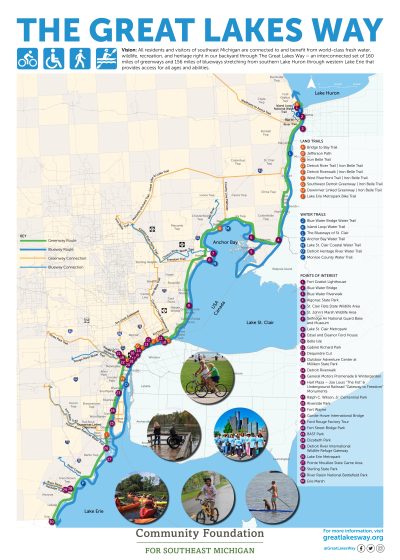
In 2019, the Community Foundation established the Great Lakes Way Advisory Committee to create this coastal necklace of greenways and water trails. The advisory committee included representatives from nongovernmental trail organizations, cities, counties, the National Park Service, First Nations, and others. Community engagement undertaken by the Community Foundation resulted in 45 communities and other stakeholder groups signing collaboration agreements in support of this initiative. The Community Foundation also recruited the Southeast Michigan Council of Governments to develop and maintain an interactive map that traces trail routes and identifies points of interest along the way.
By 2024, all 156 miles of water trails were complete and usable, although it was recognized that more kayak launches would be added in the future. Based on systematic surveys, the number of greenway miles increased from 160 in 2020 to 167 in 2024. This increase resulted from finding more efficient routes. These surveys also documented that the number of usable and funded greenways increased from 104 miles in 2020 (65%) to 124 miles in 2024 (74%), demonstrating substantial progress in the first five years.
Other five-year accomplishments of The Great Lakes Way included:
- a Memorandum of Understanding was signed by Trans Canada Trail, Ontario’s Great Lakes Waterfront Trail, Michigan’s Iron-Belle Trail, and The Great Lakes Way to promote cross-border trail tourism once a new border crossing called the Gordie Howe International Bridge opens in 2025;
- a Canada-U.S. Conference focusing on cross-border trail tourism was convened with many partners at the University of Windsor in October 2024; and
- an economic benefits study of The Great Lakes Way was undertaken that showed that the total economic impact of this trail system was estimated at $3.75-$5 billion annually.
As greater awareness was achieved of The Great Lakes Way and its benefits, other states started inquiring about how they could become part of such an interconnected Great Lakes trail system.
Chapter 3: U.S. Great Lakes Waterfront Trail
Establishing a U.S. Great Lakes Waterfront Trail will take an organization with demonstrated long-term success in working among the eight Great Lakes states, established trust, and effective boundary spanning skills (i.e., facilitating collaboration across state boundaries and between different departments and disciplines). Following an investigation of potential organizations, the Council of State Governments, Midwestern Office (CSG Midwest) stepped forward to fill this leadership role. It is a nonprofit organization with more than a 90-year history of fostering interstate exchange of insights and ideas that help states shape public policy and serves as a nonpartisan champion of excellence in state government.
CSG Midwest started the initiative by convening a regular series of roundtable discussions (approximately every four months) among the eight Great Lakes states, the National Park Service’s Rivers, Trails, and Conservation Assistance (RTCA) Program, and key nonprofit trail organizations to gauge interest and identify preliminary deliverables. The RTCA program supports community-led natural resource conservation and outdoor recreational projects nationwide.
In 2024, the CSG Midwest received a non-financial, technical assistance grant from the RTCA program to work with state partners to map this trail along 84 counties in the eight states, complete a gap analysis, and assist CSG Midwest with facilitation and partnership-building. Both RTCA landscape architects and planners, and Purdue University geographic information system (GIS) experts, are working with state and local agencies to identify conceptual trail routes, including identifying which segments are complete and usable, planned, or represent a gap. The mapping is projected to be completed in December 2025.
Roundtable participants agreed that the benefits of this trail collaboration include expanding outdoor recreation and ecotourism economies, promoting conservation, encouraging healthy lifestyles, and enhancing quality of life. It was further agreed that this trail would be a collaborative effort of the eight Great Lakes States, and that it would build on the foundation of existing trails and rely on local communities to voluntarily complete trail gaps over time. The goal would be to welcome as many non-motorized users as possible and provide unforgettable land and water trail experiences along the Great Lakes, promote and enhance local trails, and serve as a gateway to these continentally significant natural resources and their region.
Key values of the U.S. Great Lakes Waterfront Trail would be:
- support and amplify local trails and local trail identity;
- focus on equitable access to the region’s natural amenities;
- encourage cross-border and binational connections that support tourism;
- provide primarily bicycling and pedestrian recreation, but with no prohibition on other locally designated trail uses;
- promote Great Lakes outdoor recreation, ecotourism, Tribal sovereignty, and strong local economies;
- connect people with nature and support healthy living;
- celebrate local and regional history and Great Lakes heritage;
- bridge local points of interest;
- support conservation, sustainability, and environmental education; and
- aspire to be an entirely off-road trail.
The first state to be mapped was Indiana. This trail is locally known as the Marquette Greenway and will be approximately 60 miles long once completed, with 67% already built. Other states were mapped to quantify existing coastal trails that could possibly become part of the Great Lakes Waterfront Trail network. The next states mapped were Illinois (68 miles long and 86% complete), Minnesota (163 miles long and 31% complete), and Pennsylvania (68 miles long and 28% complete). Mapping is underway for both Wisconsin and New York. The final two states to be mapped will be Ohio and Michigan.
Wisconsin has 820 miles of Lake Michigan and Lake Superior shoreline. “This coastline is a significant and magnificent part of the state’s geography, contributing to its recreational opportunities and economic impact valued at $11.4 billion annually USD,” said William Pennoyer, chair of Wisconsin’s Nonmotorized Recreation and Transportation Trails Council. “Becoming part of the Great Lakes Waterfront Trail would bring greater recognition for being part of a trail system that spans the entire Great Lakes―one of the natural wonders of North America, and contribute to Wisconsin’s outdoor recreation economy.”
Through this mapping, border crossings that support cross-border trail tourism have also been identified. Current border crossings that accommodate bicycles and/or pedestrians include:
- the Seaway International Bridge connecting Cornwall, Ontario, and Massena, New York;
- the Peace and Rainbow Bridges along the Niagara River in the Buffalo-Niagara Falls metropolitan area of New York and the St. Catharines-Niagara Falls metropolitan area of Ontario;
- the soon-to-open Gordie Howe International Bridge connecting Windsor, Ontario, and Detroit, Michigan; and
- the Grand Portage-Pigeon River border crossing that connects Grand Portage, Minnesota with Neebing, Ontario.
There are also many ferry crossings that will promote cross-border trail tourism. Three examples include:
- the Walpole Algonac Ferry that connects Algonac, Michigan with Walpole Island First Nation and eventually Wallaceburg, Ontario;
- ferries that go from Leamington and Kingsville, Ontario to Pelee Island, Ontario, and then connect to the islands of Put-in-Bay, Ohio and eventually to Port Clinton and Sandusky, Ohio; and
- the SS Badger Ferry across Lake Michigan that connects Ludington, Michigan and Manitowoc, Wisconsin.
CSG Midwest has also secured assistance from the University of Michigan’s School of Environment and Sustainability (SEAS). A team consists of five master’s students in landscape architecture and urban planning undertaking a 16-month capstone project through April 2026. These SEAS grad students are working with local partners in Erie, Pennsylvania to develop a decision-making framework for trail planning and design. Their approach emphasizes the integration of local infrastructure, recreational networks, greenways/corridors, and native ecosystems to create a trail system that is regenerative, connected, and rooted in the local community. The goal is to strengthen outdoor recreation and ecotourism, promote environmental stewardship, conservation, and enhance the quality of life for both people and the environment across Erie County―and eventually the Great Lakes region.
This initiative is also promoting outreach through publishing articles and giving presentations to state and local trail groups. Through this outreach and engagement, CSG Midwest is also recruiting letters of support or support statements. Examples of current supporters of the initiative include the Indiana Department of Natural Resources, the Great Lakes Commission, the Great Lakes-St. Lawrence Legislative Caucus, The Great Lakes Way, The Marquette Greenway, Northwest Indiana Regional Planning Commission, the Wisconsin Nonmotorized Recreation and Transportation Trails Council, and the Great Lakes and St. Lawrence Cities Initiative.
Next steps of this U.S. Great Lakes Waterfront Trail initiative include an interactive map, a strategy to fill trail gaps that includes local outreach, an economic benefits study, and wayfinding signage. CSG Midwest is also seeking funding to facilitate collaboration among the eight Great Lakes states and perform the necessary boundary-spanning function.
Concluding Thoughts
Although there is substantial support for the U.S. Great Lakes Waterfront Trail, many challenges remain. These include securing facilitation and boundary-spanning funding, securing greenway gap construction funding in a time of federal government funding uncertainty, building and sustaining meaningful local community engagement, and quantifying economic, social, and environmental benefits.
In 2026, the United States will be celebrating its 250th birthday―its semi-quincentennial. One way to help celebrate this anniversary could be to establish the U.S. Great Lakes Waterfront Trail through an eight-state memorandum of understanding. This would help foster greater awareness and build capacity.
For the United States and Canada, two longtime friends with deep cultural and economic ties, a binational Great Lakes Waterfront Trail has the potential to catalyze cross-border trail tourism and transboundary cooperation on shared stories, foster understanding, advance collaboration, celebrate history and culture, promote conservation and outdoor recreation, improve quality of life, and strengthen longstanding relationships between these two countries that share the longest international land border in the world.
John H. Hartig, Jessica Lienhardt, Patrick Lydon, Chris J. Morgan, Drew Hanson, and Marlaine Koehler
Windsor, ON, Brownstown Township, MI, East Lansing, MI, Duluth, MN, and Madison, WI, and Etobicoke, ON


Leave a Reply