

We live in the city of Valdivia, located in southern Chile (40° S), known in the country for its good quality of life, high biodiversity (particularly the Valdivian temperate rain forest) and a high annual rainfall (2m average). This last point always surprises and troubles visitors, especially those who come from the northern warmer and drier areas. But the Valdiviano provides comfort against these complaints by revealing a popular local saying: “there is no bad weather, only inadequate clothes”.
Urban planners in Chile should be able to differentiate and understand each macro region’s specific climate dynamic.
This phrase may be analogous to what is currently happening between urban planning and climate change in Chile. The planning being done is not bad, it just addresses a previous situation, not the current challenge: climate change. Current planning follows classical urbanism approaches instead of exploring others more in line with natural dynamics. Old concepts can hardly prepare cities to cope with the changes that are already occurring, and with those that are yet to come.
Chile’s urban policy
The newly created urban policy in Chile set, as one of its priorities, the sustainable development of cities by considering the characteristics of the natural environment in which cities are placed. Among the considerations, it suggests knowing the natural dynamics in order to respond to climate changes proactively. A study by the Climate Change Adaptation Program at the University of Notre Dame, suggests that we have a good starting point to do this, ranking Chile 30th for its capacity to respond to climate change. The index was calculated measuring vulnerability, or the “sensitivity and capacity to adapt to the negative effects of climate change”, and readiness, or the “ability to leverage investments and convert them to adaptation actions”.
However, due to the diverse climate and geographical conditions that are present in Chile (mean width 267 km; length of 4270 km), the effects of climate change on the country’s regions are not homogeneous. Research on climate change in Chile indicates that the temperature will drop in coastal areas, while in the valleys and the Andes regions it will increase. The amount of precipitation will decrease in most of the country, while dry conditions are expected to increase. Hence, the considerations described in the new urban policy, which mostly encourage people to value, conserve, and measure the local natural environment as it is, seems to be insufficient because it is not taking climate variation into account. In other words, it is not enough to plan cities in line with the geographical and climate characteristics of a particular site; it is also necessary to know how such attributes will change over time, particularly in Chile, where climate variation is already happening and is expected to increase across the 21st century.
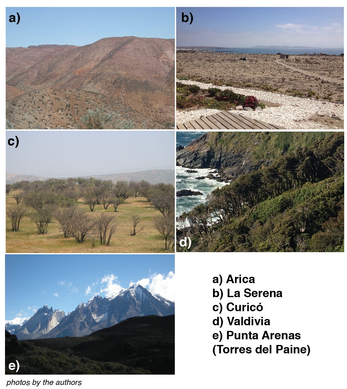
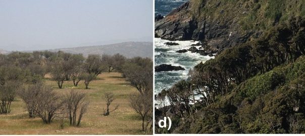
Chile’s geography incudes a northern area noted for its hyper-arid conditions and the Atacama Desert, the driest desert in the world. The Central area is known for its Mediterranean conditions, with winter rainfall and extended dry periods. In contrast, the south or temperate zone is characterized by higher rainfall—this is where the Valdivian ecoregion can be found. Finally, the Patagonia area is characterized by a higher precipitation rate in the area of channels and fjords, with vast fields of ice (Ice Fields North and South) and a tundra climate. At the same time, there are differences in the climate between what happens next to the Pacific Ocean, in the intermediate depression, and the Andean region.
This geographical diversity gives rise to a variety of climates that influence the areas were cities develop. If the aim is to take specific and timely actions in cities to prepare them to face climate change, indications of a broad urban policy and indexes that evaluate climate change “in general” are inadequate and inconclusive, in Chile’s case. What changes should be made in urban planning approaches in countries like Chile to address climate change? Rather than including new rules and expanding the list of requirements, we believe that the current terminology should be updated to the new environmental situation.
A Valdiviano may suggest that you cannot change the weather, but if you “dress” urban planning differently, you may be able to cope with it. In order to start the discussion about how to do this, we propose several alternative concepts and way of thinking that can replace those used currently.
From climate type to the study of its variations and influences
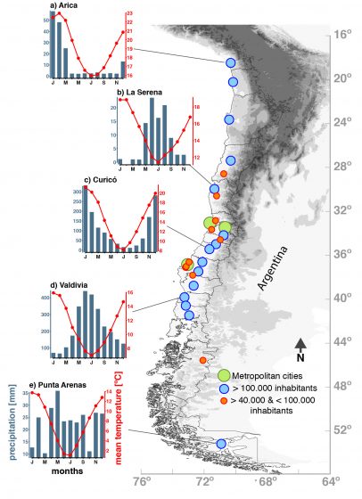
Chile’s diverse climate is produced by its huge latitudinal length, the proximity of the Pacific Ocean to the west, the Andes mountains to the east, the Atacama Desert in the North and the Patagonia and the ice fields in the south, which creates biogeographic island conditions throughout the country. In addition to the diverse topography, the north and central regions are strongly affected by global climate patterns such as the El Niño Southern Oscillation (or ENSO), while the climate variability in the southern region of Patagonia is affected by the Southern Annular mode (or SAM) forcing. Both patterns affect precipitation and temperature variations year to year. In addition, the complex topography (a result of Chilean dynamics caused by earthquakes, tectonic activity, volcanism, and erosion processes), has generated different microclimate conditions within just a few kilometers. For instance, La Serena city, near to the coast, presents every-morning-fog, or Camanchaca. At the same latitudinal coordinate, Pisco Elqui, a small town in the Andes, is cloudy most of the year (see map). In general, there are severe climatic differences from the coast toward the Andes. Overall, the history of this territory shows a diversity of climate that has changed over millennia.
Urban planners in Chile should be able to differentiate and understand each macro region as a particular climate region with a specific climate dynamic. This point will be relevant for achieving a positive future climate adaptation, where we expect a precipitation decline, temperature increasing, water stress, and an increase of drought intervals.
From land use planning to multilevel urban frameworks
Currently, the cities in Chile are governed by a regulatory framework that defines where green zones, commerce, education, and housing, among other usage types, take place. This is the current way of making cities respond to the classic urbanism approach, where the “zoning” is what determines the changes in a given place and at a given time, without much interaction with other institutions, professionals, and the environment. A multilevel urban framework, in contrast, would allow a complex and inclusive systems approach in line with the flows that change it. A multilevel urban framework is a flexible planning approach where the relationships and interactions among cities, regions, and national policies, and between the community and planners, can take place easily by adopting tools that assure vertical and horizontal cooperation. Hence, this type of framework allows the development of local action plans in line with national plans by empowering the local community, which can thus influence national policy. In turn, national policy would pursue a more efficient and sensitive implementation of urban climate strategies, appropriate to the wide climatic diversity that the country has, under a multilevel urban framework.
From urban density to urban sprawl
It is widely known that the greater the urban density, the higher the temperature, an effect called urban heat island. This phenomenon consists of the accumulation of heat in cities due to the concentration of construction materials that absorb and gather heat throughout the hours of sunlight and release it at night, preventing typical nighttime cooling. If the forecasts indicate that across the 21st century, the air surface temperature in Chile will increase between 2º and 4ºC, urban planning should not encourage urban density, but urban expansion.
Today, the discussion among planners on whether we should densify or expand cities is not conclusive. Urban density is widely used as a strategy to increase the amount of housing per hectare, which solves housing issues, particularly in developing countries. But in order to adapt to climate change, it seems that urban sprawl is an appropriate solution. A denser neighborhood does not leave space for an adequate amount of green and free areas, and as a result, deteriorates quality of life. Nonetheless, if our chosen strategy is city sprawl, the interaction between urban planners, ecologists, and engineers in transport, among others, is vital to keep natural system dynamics functioning and to avoid triggering segregation processes, which usually accompany urban expansion in this latitude.
Green areas or urban ecosystems
Increasing green areas in cities also contributes to the effect of urban heat islands. But would it be more efficient and sustainable if green areas were implemented and understood as part of the ecosystem where the city is placed? In Chile, the influence of the English garden on how green areas are designed is strong: large areas of lawns are observed in public areas all along the country. These require a lot of water, which is unsustainable considering climate change and rising temperatures. Therefore, it is necessary to change the design of green areas, and to modify this concept in the national legislation. The concept of a “green area” as an area of ornamental plant species only should be made more flexible, to accommodate plant species services and functions, and to understand them as urban ecosystems which vary from region to region. In this way, we can move from the static conception of green areas associated with classical urbanism to new urban landscape dynamics, allowing the development of sustainable cities in tune with the environment. In this case, the interaction of landscape architects and urban ecologists is essential for integrating ecology into urban planning.
Public space or multifunctional landscapes
In Chile, within the outcomes of climate change are the negative effects of natural disturbances, such as earthquakes and tsunamis. Urban planning in this regard is quite poor, since efforts have been focused mostly on mitigation strategies and on improving construction codes. Therefore, it might be useful to think that public spaces with other functions and designs could be used to counteract the effects of such disturbances. During everyday life, public spaces are spaces for recreation, but after a great disturbance, the perception of them changes: they are used for shelter, evacuation routes, and even to meet basic needs such as access to water. Thus, the concept of public space could be changed to multifunctional landscapes. Certain urban places may have more than one role, thus contributing to the adaptation of the city after a major catastrophe. In this case, architects, urban designers, and environmental psychologists should interact to plan these spaces in response to local needs.
With these ideas, we suggest that both the policies and instruments of urban planning in Chile should “dress” differently to be more flexible and adaptable to climate change. Similarly, urban planning should allow the incorporation of a diversity of professionals from the natural and social sciences throughout the planning process, who can propose new concepts and ideas for making cities more adaptable to climate change.
Paula Villagra and Alvaro González
Los Rios and Valdivia
about the writer
Álvaro González Reyes
Álvaro González Reyes is a Ph.D. student in the University of Chile’s Geology Program. His research interests include water resources and glaciology, past hydroclimatic variability using tree-rings as proxies, and climate dynamics, focused on understanding these changes across the Arid, Mediterranean, and Patagonian Andes regions in South America.
Leave a Reply