In November 2016 there was a celebration in London: it had been 40 years since the idea of creating an Ecology Park in central London was first suggested. The event provided opportunities to share memories of those early days and to see how the concept has taken root and proliferated. We met near Tower Bridge on the site of the original park and walked from there along the south bank of the Thames to the redeveloped docklands of Rotherhithe, ending up at Russia Dock Wood and Stave Hill Ecology Park. There was much for us all to learn.
We need to learn from our great successes and ensure that their legacy survives.
The Walk had been suggested by a team who are currently investigating the historical development of ecology parks in this part of London, and I was struck by the fact that most of the people who attended were too young to have known how it all started. It seemed that knowledge of the first ecology park and its achievements had already been lost in the mists of time. It certainly wasn’t history to me, as I had been closely involved, but it made me realise how quickly a body of knowledge can be lost between two generations.
Early days at William Curtis Ecological Park. Spreading the subsoil in January 1977 before the planting started. The Tower of London, built in1078, lies across the river. Photo courtesy of David Goode.
I told the story: how Max Nicholson, who was one of the most influential conservationists in the U.K., persuaded the Queen’s Silver Jubilee Committee that they should create an Ecology Park as part of the celebrations to be held in 1977. His idea was to convert an unsightly patch of derelict land on the south bank of the Thames next to Tower Bridge into a mixture of natural habitats that could be used for environmental education by local schools. I suspect that few of the committee members had the slightest notion of what he had in mind. It was completely novel. But it fitted their aims, which were to improve the landscape along the proposed route of the Silver Jubilee Walkway being planned along South Bank from Westminster to Tower Bridge. Not only would the project remove an eyesore, but it was argued that an ecology park could be created quickly and at a fraction of the cost of conventional landscaping. Given the constraints of timescale and available funding, the committee quickly agreed. The result was that two acres of derelict land were made available on a short-term lease, on the understanding that the park would eventually close when planned development went ahead. The committee also provided the modest sum of £4,000 towards the cost of creating new ecological habitats.
A dramatic success: William Curtis Ecological Park in 1983, with Tower Bridge behind. Photo courtesy of David Goode.
Where did the idea for an ecology park come from? I think it likely that Max Nicholson’s proposal was influenced by the work of Lyndis Cole, one of his staff at Land Use Consultants. She had just written an article in Landscape Design describing Dutch techniques for the creation of naturalistic plant communities in urban areas. She was a real pioneer and it was no surprise when she was given the job of creating the new ecology park at Tower Bridge. Her plan, drawn up in November 1976, indicated the range of habitats to be created, including a small meadow, mixed woodland, willow carr, and a shallow pool. These habitats were inspired by the natural parks known as Heemparks, which had become well established in towns and cities in the Netherlands, where they provided opportunities for inner-city children to have contact with nature.
The new park at Tower Bridge opened in time for the Queen’s Jubilee celebrations in May 1977. It was called the William Curtis Ecological Park, named after the eighteenth century botanist who produced the first flora of London–possibly the first publication to be devoted to urban nature. William Curtis Park was to become another pioneer. Its success took everyone by surprise. Commentators in the media could not believe that such an apparently natural environment could be created so quickly on the rubble of derelict warehouses.
A school group collecting “mini-beasts” from the pond. Image courtesy of David Goode.
The park was also an immediate success with local schools. It was booked solidly for classes through every term. Two teachers were appointed, one for younger children and the other for teenagers. They were learning fast on the job, developing teaching aids that were related specifically to the urban environment. The rate of colonisation by plants and “mini-beasts” exceeded all expectations, and this provided a wealth of material for detailed studies of urban ecology. The increasing diversity of butterfly species from six to 21 over seven years was particularly dramatic. It demonstrated very clearly what is possible in the middle of a large city.
The William Curtis Ecological Park closed in 1985 to make way for new developments. During its short life, it had over 100,000 visits from local schoolchildren. It provided a link with the natural world that was a new experience for these inner-city children. For some, it was a place they will remember all their lives. But the park left another legacy that persists. It paved the way for other, more permanent ecology parks in the new development zones along the Thames and in the redundant docklands. In the mid-1980s, the charitable trust that ran William Curtis Park rebranded itself as the Trust for Urban Ecology to promote these and a host of wider initiatives. Some of the ecology parks created at that time still exist today. One of these is Stave Hill in the old docklands of Rotherhithe.
So we return to our celebration, for it is 30 years since Stave Hill was constructed, and we wanted to see how it has fared. We walked through the new residential district, along canals and waterways with bridges and bollards dating from the time when this was a hive of maritime activity. Russia Dock, where the ships brought timber from Siberia, is no more. It was filled in and planted with native trees in the 1980s to form Russia Dock Wood, part of the ecological landscape that has become so characteristic of Rotherhithe. We arrived at Stave Hill to find the Trust for Urban Ecology (now part of Conservation Volunteers) still going strong. The trees have grown and matured since I was last there in the 80s, but the vision is the same.
Aerial view of the park in 1983. The Thames embankment is in the foreground. Photo courtesy of David Goode.Map of the various mini habitats in 1984. Image courtesy of David Goode.
There has been great continuity at Stave Hill. Rebeka Clark has been working there since 1989 and still runs things today. She points out that everyone has gained from the far-sighted vision established in the early years at William Curtis Park. I am glad to hear that those words are not forgotten. As well as all the structured educational visits to Stave Hill, there is a more informal monthly children’s club, Kids@StaveHill, and a program of volunteer days for local people on Wednesdays and Saturdays. The park also provides opportunities for corporate teams from banks and investment companies to gain experience in environmental projects. These volunteers find themselves building bat boxes or constructing bee walls, as well as doing their fair share of habitat management in the wetlands and woodland. Their contribution amounts to over 700 days of work every year.
The park also benefits from people undertaking community service. Others use the park to complete their John Muir awards. Every year, in May, local residents are invited to join a dawn chorus walk. This year, they were treated to a great surprise: the song of a grasshopper warbler coming from the reed bed at Lavender Pond nature area. A wetland warbler in the middle of a housing scheme!
The ecology park still seems to get by on a shoestring budget, but what impressed me was the way it is supported by the community. People here know what ecology means. They have lived next to an ecology park for 30 years. Their children have come here from school and many residents have volunteered to help. The park is part of the community. For many of these people, knowledge of kingfishers, cormorants, hedgehogs, and herons is part of life.
From those small beginnings near Tower Bridge, a new philosophy has taken root. Stave Hill is not alone. Camley Street Natural Park, created in the 1980s on a disused coal yard at King’s Cross, has become one of the most successful nature parks in the U.K. and is a showcase for the London Wildlife Trust. Another is the Greenwich Peninsula Ecology Park, a four-acre wetland along the banks of the Thames constructed in the late 1990s as part of a major housing scheme and managed by Conservation Volunteers (which has now absorbed the Trust for Urban Ecology). The project officer, Tony Day, tells me that the vision created by the William Curtis Park is still firmly with them at Greenwich Peninsula Ecology Park. Last year, the park had 12,000 visitors and a host of activities, including 48 school visits involving 1,200 schoolchildren. They also had six work experience placements and provided material for 27 higher education projects in Environmental Management, Product Design, and Landscape Architecture.
Four acres of wetland habitat at Greenwich Peninsula Ecology Park, together with 600m of board walks, two bird hides, and a visitor centre. Overlooked by high-rise residential development. Photo: David Goode
These are places created specifically for nature to thrive in the city. They are places where local people, and particularly children, can relate to the natural world. We need more of them.
But we also need to retain the knowledge and experience gained in these endeavours.
The legacy of the early days of ecological parks in London still exists in written records, especially in the annual reports of the William Curtis Ecological Park and the Ecological Parks Trust, together with its successor, the Trust for Urban Ecology. They contain much information about the projects carried out as part of the educational programmes, together with detailed accounts of the monitoring of ecological changes. This is valuable material that needs to be more readily available. I am glad to hear that the team investigating the history is intending to digitise these archives. But there are other records, too, in the form of published papers and books by some of the people involved. We need to ensure that practitioners today do not lose sight of these sources.
Here are just a few of the key items that tell the story in more detail:
Cole, L. & Keen, C. (1976) Dutch techniques for the establishment of natural plant communities in urban areas. Landscape Design 116, 31-34.
Lyndis Cole. 1986. Urban opportunities for a more natural approach. In: Ecology and Design in Landscape. Bradshaw et.al. Eds. Blackwell Oxford.
Jeremy Cotton. 1982. The field teaching of ecology in central London – The William Curtis Ecological Park 1977-80. In Bornkamm et. al. Eds. Urban Ecology Blackwell Oxford.
Malcolm Emery. 1986. Promoting Nature in Cities and Towns: a practical guide. Croom Helm and Ecological Parks Trust.
David Goode. 1986. Wild in London. Michael Joseph (see pages 179-181).
David Goode. 1989. Urban Nature Conservation in Britain. Journal of Applied Ecology 26, 859-873.
David Goode. 2014. Nature in Towns and Cities. Collins. (see pages 318-9).
David Nicholson-Lord. 1987. The Greening of the Cities. Routledge (see pages 120-122).
In recent presentations about green cities and green urbanism I often play for audiences several common natural sounds, to see whether they recognize what they are hearing. Here is one of the sounds I often play—something commonly heard in communities in the eastern US.
The fact that so many fail to recognize these sorts of common nature sounds suggests something about our disconnect from the aural realm, perhaps the fact that we have lost the skill or desire to carefully listen to the world around us.
The subject of sound needs to be more squarely on the agenda of urbanists. We have tended in the urban planning and design fields, in which I teach, to privilege the visual, to celebrate the ocular. Unfortunately, this often results in lesser attention given to the other sensory experiences that make up our lives. I have become especially concerned with sound, and its persistent under-recognition as a key factor in quality of life and in overall human health and happiness.
Much of what makes me happy and content involves the things I hear, and much of that has to do with the rich and complex sounds of the natural world. Biophilia, and biophilic urbanism, are in essential ways multi-sensory, and sound is a key dimension. A natural soundscape is an essential aspect of livability and quality of life, I believe. Hearing these beautiful sounds makes us happier, as does seeing and experiencing the animals and nature that produce the sounds. However, we have left the management and stewardship of urban soundscapes to chance. It is time for cities to assume some badly-needed sonic leadership, and as the discussion below suggests there are in fact many things that cities can do.
The biophilic soundscape of cities
A tree frog—a “peeper”—from the eastern US. Photo by Tim Beatley
There are many natural sounds that I look forward to everyday and some I count on to mark the seasons of my life. I look forward to hearing the spring sounds of peepers, for instance, and to the glorious and cacaphonous sounds of birds. The summers along the eastern US present perhaps my favorite aural season, with evenings full of lulling katydids, crickets and tree frogs, among others, inextricably linked in my own DNA with humid and hot lazy summer evenings.
Click here for a sample of nighttime sounds in Virginia in late summer.
There is no end to the diversity and complexity of the natural sounds around us, it seems. Bird songs are a mainstay, of course, and winter finds literally hundreds of robins cackling and chirping at daybreak outside my central Virginia door. And there is the tap of the pileated woodpecker, more like a wood sculptor skillfully swinging a mallet than digging for grubs. But there are natural sounds of many kinds, from voles to bending trees and wind-rustled leaves, even to the sounds of eastern woodland snails eating, if we listen closely and carefully (as Elisabeth Tova Bailey so eloquently tells us in her beautiful book on this topic, The Sound of a Wild Snail Eating; and no wonder, as they have some 2640 teeth! You can hear a small snippit of the snail eating at Bailey’s website here.
Few scholars of sound are more accomplished than Bernie Krause, who has been collecting and analyzing natural soundscapes around the world, and what their changes tell us about ecology and biodiversity (most especially in his recent book The Great Animal Orchestra). Krause distinguishes between geophonies (running water, moving trees, the rumble of moving glaciers) and biophonies (sounds emanating from living organisms), painting a picture of soundscapes of incredible diversity and complexity. From blue whales to ants to corn growing, Krause argues all life is sound-generating, and moreover we have co-evolved with these sounds and connect with them and enjoy them in important ways. “It is likely that buried deep within the human limbic brain is ancient wiring that springs to life every time we reconnect with these delicate webs of acoustic finery…” (Krause, 2012, p.105).
Listening to these deeply nourishing sounds—what Rachel Carson has called “nature’s music”—serves to calm me, steadies me, reassures me that I am in the right place, and causes me to remember family and childhood in a deep and visceral way that few other sensory experiences can. Indeed I would argue that biophilia is very much a multisensory experience, by definition, delivering much of the therapeutic power and punch that nature provides us. Natural sounds are an important entre into the mystery of life around us, a kind of aural portal or window into the complexity and diversity around us. In an age where so many things seem to be known or knowable, there are many sounds that essentially convey a mystery and wildness that we lack in other dimensions of life.
I think we need to do a better job celebrating the soundscape, cherishing those special sounds in our lives, and protecting the natural soundscapes that exist, as well as referencing these valuable benefits when we work to protect and restore natural spaces in urban settings.
How do we know that natural sounds are beneficial? We have considerable anecdotal evidence, of course. There is the interesting example of the Southern California city of Lancaster, where, through the leadership of the city’s mayor, R. Rex Parris, a network of 70 speakers plays bird sounds along a major boulevard. The mayor claims that minor crimes have gone down as a result. “Everybody is now is a better mood, a better place,” Parris told the Wall Street Journal. The positive calming effects are believable to this author, though one wonders about the merits of artificial broadcasting when the goal should be to protect and foster a healthy natural soundscape (and sufficient urban habitats to ensure real bird sounds).
Studying the natural sounds of cities is an increasingly important dimension of urban ecology, as recent studies have shown. It is interesting that the non-human inhabitants of cities seem to find ways to adapt to urban noise, perhaps more cleverly than we have. Recent studies have shown how background noise can disrupt grasshopper mating calls in cities, for instance, but also how these species adjust the frequency of their calls in response (BBC Nature, 2012) [To listen to calls of the male bow-winged grasshopper visit here. Similarly, birds such as sparrows have also been shown to modify their songs in response to noisy urban traffic (e.g. Science Daily, 2012).
What can cities do? Manage noise to foster nature-connections
Not all urban sounds are pleasant of course; many are not. Modern society is full of ubiquitous mechanical and engine sounds—cars and airplanes in particular—that seem ever-present and serve to destroy and drown out the sounds of nature. We rightly worry about the health implications and negative impacts of high-decibel sounds on hearing, but often tend to overlook the lost positive values and life-enhancing value of hearing nature and natural sounds. Controlling these mostly negative elements of our collective soundscape is a major challenge for us.
Many of these sounds—the noise—are indicative of patterns of unsustainable living and consumption. The fall season along the eastern U.S. brings many sounds that represent energy consumption and air pollution—one thinks notably of the ubiquitous presence of leaf blowers: two stroke engines that bellow so loud that conversation even indoors becomes difficult, and supplant human labor and care with air polluting, fossil-fuel-burning force. There is an irony that in a time when many Americans would benefit from greater physical activity (i.e. raking leaves) the leaf-blower emerges as an affordable technology, and one that further disconnects us (think of the ear-protection users wear) from outdoor nature, and from other humans as well.
More aggressively controlling the noises from cars is another important step. The European Union has adopted and will be phasing in overtime new auto tire standards that will significantly reduce tire noise, and this is a good step. The shift of slowing traffic in many urban neighborhoods (or eliminating car access altogether) is further supported by the benefits of being better able to hear the natural sounds there. Car-free urban districts, more common in European cities, are one way to protect and celebrate the natural sounds present in cities.
Most of the policy and community planning agenda related to sound has (perhaps understandably) mostly to do with noise—the loud and negative sounds that make life unpleasant, sometimes undermine our very health and wellbeing, and the spaces in and around cities (for instance, under airport approach zones) that are almost uninhabitable. Planning and design often seeks to control and moderate these noises—for instance through land use planning aimed at keeping residential development out of noisy areas, design of structures (windows, building materials, interior room layout) to minimize noise, and other efforts to reduce the decibel levels of the noises around us.
In some cities around the world—for instance, Scandinavian cities—emphasis in city planning has been placed on finding and protecting “quiet areas,” where peaceful contemplation and reflection, and quiet recreation, prized commodities in a large city, can occur. More cities should seek to designate and protect such areas, and enlist the benefits of spaces where a call of a lark or a squirrel, or the creak of a tree moving in the wind can be heard and enjoyed.
We often tend to emphasize those sounds that are negative or dangerous or unpleasant, but we rarely work to understand what the important positive and therapeutic sounds are in our communities. Indeed, as planners we have generally failed to acknowledge or incorporate sound (and other senses besides sight) as a planning element. Sounds, the soundscapes of a city or town, are a highly underappreciated aspect of community.
Designing homes and neighborhoods with sound in mind
We need to better study and take account of sounds in the planning and design work that we do. One step is to begin to systematically record, inventory and document the sounds, natural and human made, that exist in our communities. We are increasingly likely to advocate and expect a host of new urban greening measures—from rain gardens, to tree planting, to use of native landscaping in public parks and greenspaces—and while we may be intimately aware of their hydrologic benefits, for instance, we are not likely to take into account the impressive ways in which these green features enhance and expand our natural soundscape. No-mow zones around buildings can do much to enhance the natural sounds we experience every day, though these sounds are typically never part of our rationale or calculus.
Many communities now commonly undertake visual preference surveys as a way to extract important design principles and insights (showing a series of images of buildings, streetscapes, urban environments and asking respondents to indicate how much they like what they see). To my knowledge, however, no community has sought to catalog, record and poll its citizenry about the kinds of sounds it enjoys or cares about (or worries about conversely). Cities should consider using this kind of aural preference survey.
Listening to a water feature. Photo: Tim Beatley
We know the sound of water in cities is soothing and therapeutic as well, and a major additional reason to support efforts at river restoration, and stream day-lighting in urban neighborhoods. On a recent visit to Oslo, I recorded the fast moving water of several streams, including the Akerselva, a beautifully restored waterway that runs through much of that city. With hiking and biking paths, and numerous small bridges that allow crossing the river at key points, it is both a mobility asset and a green urban spine, and one that provides numerous points for sitting, picnicking, and rolling in the grass, all within earshot of the sounds of moving water.
Oslo, June 2010. Photo by Tim Beatley
Click here for sounds of the Akerselva River in Oslo.
One of the modern challenges of healthy sustainable living in the USA is overcoming the predominately indoor-oriented lives that most Americans experience. Green neighborhood designs can help to correct this. For instance, tree planting and creative green elements can, through shading and evapo-transpiration, effectively replace ubiquitous air conditioning and help to reacquaint Americans with open windows and doors, and the ability to overcome the physical barriers to hearing place sounds. Village Homes, in Davis, California, is an inspired and early green neighborhood with this goal. Extensive green landscaping, and passive solar designed homes, have created the conditions for closer contact with the outside world. As Judy and Michael Corbett discuss in their terrific book about the neighborhood:
“Elimination of the need for air conditioners by means of our natural cooling system creates a quiet neighborhood and allows us to be more in touch with the natural breezes and smells of summer” (Corbett and Corbett, 1999).
Some new home designs, furthermore, are creatively incorporating listening elements that collect and project outdoor sounds into indoor living spaces. Architects Joel Sanders and Karen Van Lengen have recently designed a prototype of a suburban house of the future, the MIX house, that creatively collects sounds and images from the sky and surroundings and projects them into the spaces of the house. They envision use of a series of “audiovisual” or “sonic” windows that when closed (imagine winter weather?) collect both sound and images, as well as a large tilted ceiling that collects the images and sounds from the sky into the master bedroom. These ideas are unique for home design and architecture which, as the designers note, has tended to reflect an “ocular-centric design culture.”
And perhaps larger buildings can be designed to facilitate aural experiences that connect us to nature and place. There is the example that comes to mind of the apartment complex that fellow The Nature of Cities collective writer Mike Houck took me to in Portland, Oregon, where the rainwater is collected and steered to a series of courtyard water features. Here, at 10th@Hoyt, residents reportedly come out on stormy days to listen to the rain, as it falls and makes its way down and through an elaborate system of “runnels and chutes” (Echols and Pennypacker, 2006).
Natural soundscapes as an important dimension of city planning
For those of us involved in city planning, we must find ways to integrate sound into our work—community comprehensive plans should have a sound element or chapter, and our vision statements for the future should reflect the important goals we have for our community sound environments. Perhaps we begin to formulate and express our parks and greenspaces targets to reflect a sound dimension—e.g. the goal that every neighborhood in a city reach conditions in which on any given day residents can easily hear (let’s say) 10 bird species. Many cities, such as New York, have established a goal of minimum access to parks—say every resident able to reach a park or greenspace within 5-10 minute walk. Perhaps such targets could be expanded to include not just a park, but a quiet space (within the park perhaps?) where it is possible to hear crickets?
I can also imagine instituting some form of natural soundscape performance standard for new buildings and development: requirements, for instance, that new developments prepare aural impact statements that make an honest attempt to judge likely soundscape impacts, and to mitigate them in some clear ways (e.g. new trees and vegetative elements that might help to compensate for a development’s reduction in natural sounds and increase in mechanical and human sounds).
We need to better study and take account of sounds in the planning and design work that we do. Every city might start then by preparing a sound map, a kind of inventory or aural assets. Each community, each place has its own soundscape, its own unique sound signature. Understanding this signature soundscape, and monitoring how it changes over time, should become a common planning practice.
In my own community we have begun to develop, over several years, and with the help of my students, a community sound map, as an initial effort to take stock of the many sounds that we take for granted. Every community needs a sound map, perhaps even a sound plan. With the help of my students we have been recording snippets of sound throughout the city. Understanding the unique and special sounds one would hear on different (sound) walks, we are beginning to understand the physical spaces around us are filled not with noise but with beauty and meaning and connection (though there is some noise to be sure; see here). In the process we are collectively learning to listen again—to hear things that we may have not been aware of, to savor the aural flavors and nuances and to celebrate the connections to other life that really, truly listening can afford.
Of course not all sounds are pleasant to the ear. Many are mildly annoying (dogs barking at night), seriously stressful (airport approach and departure sounds), and some are alarming (e.g. police and fire vehicles). Like other aspects of our lives, perhaps we should not aspire to a world of only pleasant sounds, but recognize that a life fully lived in a community is one of many and diverse experiences, some pleasant, some not so, and some sounds that are recuperative, others that are disturbing, but all make up the soundscapes of our lives.
Just as landscapes change in a community and region over time, so also does our experience of sound and in fact recording and acknowledging what we hear is a kind of proxy for those changes. We are understandably concerned when we lose certain lands and habitats in and around communities, but for me part of what that is unfortunate is that we often also lose the special sounds that those spaces provide. Sounds and soundscapes then offer another window or measure or marker for understanding the change in our communities. Not all of these changes to the community soundscape are negative, of course, but many are. And it is rarely the case that there is much explicit discussion (or any) of the diminished soundscape that community changes typically wreak.
Hearing the nature around us
Despite the many competing sounds and noises in cities there is much to hear if we try. Too often we don’t try, and like the failure to recognize plants and animals visually (that common species of tree or bird) we don’t recognize the sounds that we do hear.
Let’s return to the natural sound presented in the beginning of this essay. Did you know what it was? At once exotic and unusual sounding, most audience guesses are wrong. Many suggest a tree frog, but most are baffled. I then show a photo and usually the audience is quite surprised to see that it is the call of the eastern screech owl. It is seemingly an exotic sound, a twittering and a horse-like downward whinny.
It is a common co-inhabitant of urban and suburban environments. I must admit that what initially led me to this unique sound was hearing it my backyard one evening. It is a sound that once heard is not easily forgotten, and indeed a very common sound in suburban neighborhoods throughout the eastern U.S. Yet it goes unrecognized and we miss the opportunity to acknowledge and enjoy the life around us, in this case the special night sounds that make leaving the windows open in the evening so enjoyable. Knowing that sound (it turns out that screech owls don’t actually screech!) moreover, deepens both my understanding of but commitment to that place in which I live, and I have found myself on many nights longing to hear the screech owl again, as a kind of returning friend, an important and valued member of community and neighborhood.
The sound signature of each community will be unique and different, of course, and is at least a part of what makes a place special and distinctive. Many of these sounds are human-made (and not all them noise), and it is the unique blend of sounds that makes a unique signature. On a visit several years ago to Iowa City, Iowa, home to the University of Iowa, I discovered some interesting ways in which that city’s and region’s soundscape is distinctive or different. The university’s power plant, for instance, has historically blown a whistle to mark time, four times a day: 8am, 12noon, 1pm and 5pm. It’s a distinctive whistle to be sure; it got my attention when first I heard it. And several years ago they stopped the practice briefly, with the understanding that the time-marking function of the whistle was no longer needed. But there was a community backlash from the decision and the whistle was restored. In this city the whistle has become a reassuring and familiar sound, a part of the city’s identity, indeed its self-identity. There are countless other sounds—from the low clattering of plates, dishes and silverware of outdoor restaurants, to the distant rumble of a train, that can blend together pleasantly.
Part of the challenge moving forward may be that we need to learn (or is it re-learn?) how to truly listen in the places we live. We will need to cultivate a curiosity about what we hear, and ask ourselves, and each other, what or who is making a particular sound. But we will also need to find the resolve to be still and quiet occasionally, to resist the buzz and bell of our cell phones, long enough to hear the wonderful voices of the life around.
Tim Beatley
Charlottesville, VA USA
What are some of your favorite urban natural sounds? Take a moment to record one of them and send it to [email protected]. We will try to post it here. MP4 or WAV format please, and no more than 60 seconds long. Include as the title an identifcation of the sound and where and the date it was recorded. Please, only sounds you have recorded yourself.
House Sparrows. Near Union Square, Manhattan, New York City. 12 January 2013. Recorded by David Maddox
September 2014 marked the 50th anniversary of the signing into United States law of the Wilderness Act. A watershed act and a cornerstone of contemporary environmentalism, it put into place new and important safeguards on the protection and development of some of the nation’s most impressive wild areas.
As we celebrate the accomplishments of this act and the incredible wild and wondrous places it protects, it is timely perhaps to re-consider the concepts of wilderness and nature in our lives, and to consider they ways they will necessarily need to evolve and change in an increasingly urbanized planet.
The Wilderness Act of 1964 contained an essential and oft-repeated definition of wilderness: lands that are “untrammeled by man, where man himself is a visitor who does not remain”, and an area “retaining its primeval character and influence, without permanent improvements or human habitation”. The Act created the National Wilderness Preservation System (NWPS), and now protects more than 9 million acres, placing important restrictions on road building and development in these areas, and ensuring the preservation of their wilderness qualities and habitat values.
The Act was a remarkable accomplishment, and a ringing endorsement of the value of wild places and the quiet solitude of nature in a modern world. But the Act has also had the unintended consequence of helping to solidify the particular notion that genuine or “authentic” nature is remote, pristine, necessarily large in size, and for the most part absent human beings.
LEFT: U.S. President Johnson signs the Wilderness Act of 1964., RIGHT: The Bob Marshall Wilderness, Montana.
Re-thinking urban wildness
Perhaps on this important anniversary it is time to broaden our view of wilderness, not to deny the value of experiencing remote quietude, but to acknowledge the equally valid experiences of wild nature in and around cities, where most people live.
Much has changed, of course, since 1964 and our knowledge of the history of land and landscapes has grown in some important ways. Book’s like Charles C. Mann’s 1491: New Revelations of the Americas Before Columbus, for instance, have helped to show the true (and considerable) extent to which native peoples have actually modified the landscapes in which they lived. The long-popular view of the new world as a verdant land, untouched by human hand, has been shown to largely false. There are few places in North America or elsewhere that have not been highly impacted by humans, and thus the very notion of pristineness has come into question.
Belle Isle, in the James River, Richmond, Virginia, USA. Photo: Tim Beatley
Equally true, we increasingly recognize the importance of natural areas that are in symbiosis with humans, and understand that any notion of modern environmentalism must include, not exclude humans. There has also been a significant rise in the body of research showing how important access to any contact with nature is our health and happiness. We know that we need that connection, that contact with nature, not just during an occasional holiday or summer vacation, but we need it daily or hourly. We need nature all around us and nature, so the new view holds, necessarily need not be remote or distant, but is often more essential and useful when it is near to where we live and work.
Landscape historian William Cronin helped in the mid-1990s to stimulate new thinking and discussion about what we think of as nature, most importantly in his book Uncommon Ground: Rethinking the Human Place in Nature. As Cronin says there, “Wilderness gets us into trouble only if we imagine that this experience of wonder and otherness is limited to the remote corners of the planet, or that it somehow depends on pristine landscapes we ourselves do not inhabit”. When talking of cities perhaps wildness is a better word.
The potential for experiencing the wonder and amazement of the natural world is all around us, even in dense cities, and thus we need to embrace a new, expanded view of nature, one that understands that the qualities wildness can be found in many places and spaces that may not fit the usual stereotype.
We must work to overcome an overly purest view of wildness that questions natural views and settings that contain buildings or urban skylines. The experience of urban wildness may be more fleeting, less immersive, than the Wilderness Act envisioned, but better fits the reality of urban life. We need wild places a close walk or bike ride, or a quick transit trip away.
The Wildness of the Nature of Cities
We know, for instance, that there is immense biological diversity in the soil, and in water at a microscopic level. E. O. Wilson has referred to this as “microwildernesses”: “A suburban woodlot is obviously no longer a wilderness for mammals, birds, and trees. But it might be a “microwilderness” for small organisms” (2006, p. 18). We know that there is often remarkable wildness in the diverse world of the many other small things around us, from moths (there are more than 10,000 species of moths in North America, many of which are micro-moths), to lichen, to mushrooms and fungi. Larger green spaces will remain important, of course, but much of this wildness is delivered in the often small, but potent, interstitial spaces of cities.
Precisely what constitutes wildness, and what stimulates the feeling or experience of wildness, remains an open question. It is certainly a complex set of conditions, to be sure, but some mix of sense of the immensity of the scale and uncontrollability of forces at work, that it exists without much concern for the human world, and lives and thrives in ways that are, to some considerable degree, mysterious and unknowable even. It is the sense we get from things that seem untamed, undomesticated. Perhaps it is the glimpsing ways in which we see the nature around us—and the largely hidden lives that characterize much of natural world. And it is the fierceness and force of nature often that seems to impart its wildness and demonstrate its untamedness, as with a flooding river or fast creek, or a windstorm or hurricane.
Which is all to say that these qualities of wildness, and the experiences of wildness, need not be restricted to remote “wilderness areas”, areas far away from cities. The experience of wildness, moreover, need not be a solitary experience to be meaningful or beneficial. It can happen even in the presence of many others, for instance when hundreds congregate each fall in Portland, Oregon, to watch the amazing spectacle of thousands of migrating Vaux’s Swifts as they converge on a school chimney to roost for the evening.
We need to replace the perceptual dichotomy that many still carry in our heads between cities and nature. The evolution in our thinking should encompass the new ways in which flora and fauna are evolving and adapting to cities and urbanization, and we’re only now beginning to understand this. Bird species are changing the frequencies of their songs in response to urban and traffic noise, for instance. And increasingly there are examples of “new” forms of nature, what ecologists sometimes call novel ecosystems, unique assemblages of native (and non-native species and habitats, that have formed in and around cities. Perhaps there is need for unplanned ecological spaces in our notions of urban wildness; making room in cities for a sort of ecological improvisation, with sometimes unexpected results. We will need to adjust our ideas about nature to include these ways in which the nature in the future will be different from what we previously have known.
Part of this urban wildness is on display where formerly developed or human-occupied is, for some period of time, given over or given back to nature. One thinks of the experiments in re-naturalizing in the Emscher Park, in the Ruhr Valley of Germany, or the newer efforts to re-purpose spaces in Berlin, such as the former Templehof Airport (now an urban park larger than Central Park in New York). There is even an organization called “Abandoned Berlin” celebrating the many places, like Spree Park, a former amusement park now, and at least temporarily, given back to nature. Setting aside areas in and around cities for re-naturalizing, or re-wilding, is close to the notion put forth by environmental philosopher Paul Taylor in his classic book Respect for Nature: “rotation” or “taking turns”, he indicates is one method for advancing distributive justice between and among human and non-human species. An urban nature version perhaps of leaving agricultural fields fallow, the longer-scale rotation of some lands in cities offers opportunities for forms of wildness quite different from those imagined by the Wilderness Act.
This opens as well the possibilities of designed wildness in cities. Perhaps a contradiction on some level, architects and urban designers increasingly recognize the need to accommodate some degree of wild nature into the very corpus of buildings and urban structures. University of Buffalo architect Joyce Hwang has been innovating here, experimenting with new human-designed structures to accommodate bats and other urban critters (she has designed a beautiful, prototype bat tower, and a series of hanging bat pods that she calls a Bat Cloud). She is also working on creative new ways of re-imagining building walls and facades that also serve as important urban habitat (“pest walls”, she calls them , in her essay “Constructing Wilderness”). Part of her key goal is to make the wildness visible to urbanites.
Urban notions of wildness will necessarily entail a hybrid mixing of the built and natural. An emerging example close to my heart (and geographically close), can be seen in Richmond, Virginia, where a wild river ecosystem (the James) interacts with a highly designed and constructed city. It is an unusual but desirable juxtaposing—class five rapids, and a rocky, powerful river in close proximity to where people work, live, walk and recreate, and exhibiting daily the conditions of nature only partially predictable and controllable.
The James River, Richmond, Virginia, USA. Photo: Tim Beatley
Access to this river wildness has become a key feature of planning for the City of Richmond, and a new Riverfront Master Plan seeks to foster new opportunities for contact. One place where this is already possible is on the Pipeline Trail, a walking trail on top of an actual large pipeline running parallel and in the river itself. Visitors can walk along this trail, a breathtaking experience when water levels are high, and even more breathtaking when the re-assuring handrails disappear from the pipeline. There is a certain feeling of danger here, which may be another dimension to experiencing wildness, and on virtually any day a visceral sense of the power and fury of this majestic river.
And there are many other places along this urban stretch of river where its wildness can be enjoyed. Kayakers run the rapids, bathers and swimmers make cautious forays, kids and families hop from rock to rock in a fascinating kind of archipelago that exists near the northern edges of Belle Isle, all within sight of the tall buildings of downtown Richmond.
The Pipeline Trail in the James River, Charlottesville, Virginia, USA. Photo: Tim Beatley
On a recent visit with students from my Cities + Nature class, we found a churning river, with abundant Shad (a migratory fish quite important to the history of the river) jumping and swirling in the eddies of the water caught in the corners of foundation walls. Walking on the Pipeline Trail takes you in close proximity to a large heron rookery, and on that day these majestic birds were sunning, and on the look-out for Shad, as was the Osprey flying overhead, all within a few hundred feet of a busy downtown. These experiences are as wild and exhilarating as any that might be in a more remote setting.
Wildness may in some ways challenge the very notion of contemporary urban planning. Some planners will resist the notion that there are things in the urban realm—natural forces, biology, flora and fauna—that are largely beyond our control (a point that David Maddox made in reading an early draft of this article). Yet, as I have suggested there may well need to be modes of urbanism and urban planning that emphasize designed wildness.
How to take this wildness into account in the formal plans and planning processes of cities remains an open question. Not many contemporary urban plans explicitly aspire to wildness, I suspect—and UVA PhD student Julia Triman is currently analyzing city plans to see if this is the case. On the contrary, we should begin to both advocate for and celebrate the many ways in which wildness, and experiences of the wild, can be seen to occur, and can be actively fostered as an important and desirable urban quality.
A desire for a wild city, or places of wildness in the city, should be included in a plan’s statement of goals and vision. Urban plans, moreover, might designate wild corridors, or wild urban zones (the watery edges of the James River in Richmond, for instance), or perhaps areas of planned re-naturalizing or re-generation? In part this would help to cultivate the wild sensibilities we want citizens and residents to bring to these places, and see and appreciate them for the wildness they present, in contexts that may seem surprising.
Note: A shorter version of this essay appeared as Beatley’s Ever Green column, in the October issue of Planning Magazine (published by the American Planning Association).
An initial glance may suggest informality implies unsophistication. As Lizulu demonstrates, informal governance structures are complex and involve intricate relationships not dissimilar from “traditional” conceptions of “formal” governance systems.
Informal organizational structures are commonly involved with greening efforts in cities, such as waste recycling and urban agriculture efforts. They are particularly relevant in cities of the Global South, where large percentages of the economy and labour are in the informal sector. Collaboration between the formal and informal sectors poses a key challenge for the successful implementation of such innovative initiatives. This short article analyses the formal-informal relationship through a discussion of a river restoration project situated in Lilongwe’s largest informal market, Lizulu Market. As Malawi’s largest city, and one of Africa’s most rapidly urbanising areas, this case study constitutes a window into a pressing challenge for environmental governance.
This essay is part of a case study for the project IFWEN: “Understanding Innovative Initiatives for Governing Food, Water and Energy Nexus in Cities” (a JPI Urban Europe and Belmont Forum Project). www.ifwen.org
The context of a larger role of local governments under rapid urbanization
Many developing countries, such as Malawi, have introduced a series of decentralisation initiatives in recent decades. Malawi’s political structure takes the form of a democratic republic with a parliamentary system of governance. Following three decades of highly centralised governance, a drive toward decentralisation with support from donors occurred in the late 1990s with an aim to bolster poverty reduction strategies. As with other donor-assisted initiatives, organisations such as the International Monetary Fund (IMF) have strongly urged the central government to grant greater autonomy to local municipalities.
Plans to introduce further decentralisation measures have been frequently referenced in national plans such as the Malawi Growth and Development Strategy (MGDS) and Poverty Strategy Reduction Papers (PSRPs), introduced in 1998. The Malawi National Decentralisation Policy and the Local Government Act were key in delegating greater powers to local authorities. However, local governments, instead of being entirely independent actors, must commonly develop policy that fits within existing frameworks and broader development agendas set by the national government. Amendments to the Local Government Act made in 2010 resulted in the formation of 35 councils to be governed by local municipalities. Though city authorities do not have decision-making power over all sectors, they are granted the ability to legislate in some urban services, such as water provision and waste management. Urbanisation has occurred slowly across Malawi, with just 16.1% of its 17-million population classified as urban in 2018, but it is expected that this percentage will increase rapidly in the next decades. Lilongwe, which became Malawi’s capital in 1975, tends to continue its growth trajectory owing to its status as the nation’s political and economic hub.
Due to a lack of control over certain key sectors caused by limited decentralisation and low budgets for local services, many plans city governments draft are unlikely to be realised without significant support from the central government. Poorly financed urban services under unplanned urbanisation are key problems for many cities in the Global South. Though government masterplans suggest conserving nature is a key goal, these goals are mostly confined to paper and aren’t reflected in Lilongwe’s landscape where land allocated for green space becomes occupied by housing and commercial enterprises at apace. As a result of extensive deforestation and rapid unregulated urbanisation in recent years, the capacity of Lilongwe’s green infrastructure has diminished and continues to threaten the ecological sustainability of the urban area, making it vulnerable to disasters such as flooding, which will tend to increase in scale and frequency due to climatic changes. Insufficient waste management increases the risks of these events occurring, as a considerable proportion of the uncollected waste ends up in Lilongwe’s rivers and streams. However, in Malawi, and across the Global South more broadly, local governments continue to develop innovative initiatives with even limited resources.
Waste management in Lilongwe
Up to 700 tonnes of waste was generated daily in Lilongwe City during the early 2010s, though only around 30% was collected by public or private actors with the rest being disposed of by burning or dumping. Though efforts are being made to widen the provision of public waste collection, only the wealthiest neighbourhoods are currently serviced. As of 2015, Lilongwe’s waste management programme had just four garbage trucks in operation for a city approaching a million residents. A lack of human and financial capacity to enforce rules instated by the Environmental Management Act and the Lilongwe City Waste Management By-laws have been identified as key drivers of pollution in the city, as many new developments entail indiscriminate disposal of waste that is often eventually found in Lilongwe River. Pollution in Lilongwe River is one of the greatest concerns of Lilongwe City Council (LCC) due to its importance as the city’s main supply of water. Inherent inequities in the city’s waste management programme manifest in the unequal geography of harmful waste disposal sites, which are almost exclusively near the city’s poorest informal settlements where access to sufficient sanitation infrastructure is low.
Compost site before the river clean up started. Photo: OWI, 2017
To help address the city’s struggle with pollution and environmental degradation, a waste management scheme in Lizulu Market has been developed through a partnership between the local government and national and international organizations. The scheme is part of the Urban Natural Assets for Africa project, initially funded by the Swedish International Development Agency. Initial efforts were made to identify the most pressing environmental challenges facing natural assets in Lilongwe. Following this, waste was commonly identified by many participants as a key development challenge that poses issues for the city’s food, water, and energy sectors. A local waste management NGO, Our World International, won the bid to run the project and worked closely with ICLEI-Local Governments for Sustainability on the ground to implement the project. Overall, the initiative sought to partially resolve the pollution in Lilongwe River by introducing formal waste collection sites in order to prevent waste from the market being dumped into the river. Over 2,000 members of the community have been involved in the project’s capacity-building exercises and 22 volunteers were trained in composting. 15 tonnes of compost have been produced and workshops assisted 5,000 more on the benefits of sustainable waste management.
Challenges and opportunities for formal-informal collaboration
A key challenge for the waste management initiative was the formal-informal collaboration between LCC and the informal governance structure at the site. There were attempts to work with local government on the benefits of working with informality yet, during the initiative’s early stages, Lilongwe City Council wished to formalise the site as part of a broader project to reclaim land outside of official planning documentation. Given the informal nature of much urban service provision in Lilongwe, any initiative seeking to innovate within these sectors must engage with informality. As opposed to eradicating informality to accommodate and implement expensive infrastructural projects, it can be more cost-effective for governments to work within these informal initiatives which can instead be better incorporated into existing networks benefiting from the existing organizational capacity. This is what the initiative set out to achieve, yet it was challenged by Lizulu’s complex informal governance system.
Balancing informal and formal structures of governance was a demanding task in Lizulu, but informal organizations can be effective. In contrast to the common perception of informal governance as disorganised, each market section has its own representative that sits on a broader market committee which is associated with the Lilongwe Urban Vendors Association (LUVA). The project team liaised with LUVA to discuss issues relating to informal markets and to promote collaboration between volunteers and market vendors. Composting profits were partly redirected toward the market committee as a method of ensuring the future sustainability of the initiative.
Many composting projects are situated in places where communities live due to the strong community ties that often already exist in neighbourhoods. The story in the informal market was very different in that it is a place of work rather than residence, so it was essential that composting would generate income for the people involved. Some of the volunteers wanted the compost for their plots of urban agriculture, but the project needed to market the compost to a broader client base, to generate a surplus of compost. However, the market for compost remained limited and few buyers existed. This perhaps indicates that continued engagement outside of those in the immediate vicinity of the project, e.g., those involved in urban agriculture, will be necessary. The local government can also purchase some of the compost to use in its own agricultural land, as this would create incentives to avoid waste being disposed of in the river, which presents much higher financial costs in terms of waste removal and increase in flood risk.
The benefits of the initiative will be revealed not only through the success of the project, but through the lessons learned by the stakeholders involved which could help develop initiatives that are financially viable yet come with tangible impacts which are equitably distributed. Considering the notably small-scale nature of the project, it was unrealistic to anticipate that a small group of volunteers could clean up the city’s biggest market. Consequently, greater integration between sectors could increase the chances of success of the project. For example, urban agriculture is important for livelihoods in Lilongwe – particularly in informal settlements on the city’s periphery where many of the project volunteers were recruited from. Closely integrating composting initiatives with the city’s agricultural sector would bring incentives for further participation of volunteers. This could occur through more closely engaging strongly established informal market exchanges which have emerged through many years of urban agriculture with these recent advances in composting activity.
An initial glance may assume informality implies unsophistication. As Lizulu demonstrates, informal governance structures are complex and involve intricate relationships not dissimilar from ‘traditional’ conceptions of ‘formal’ governance systems. The case demonstrates that, when working in cities within developing countries, it is critical that informality is taken into consideration in any planning and policymaking domains, at least as a starting point. Even where there is social take-up, the extent to which a project can achieve its objectives is limited if the formal structures of governments do not learn to establish connections and collaborate with existing informal structures. By considering these embedded contextualities both throughout and prior to project initiation, issues relating to informality could be mitigated by incorporating this variable during the planning and collaborative process. This co-production planning philosophy can help ensure that environmental initiatives are equitably designed and executed to suit the needs of the communities that they seek to serve.
Andrew Hughes and Jose A. Puppim de Oliveira Sheffield and São Paulo
Jose A. Puppim de Oliveira is a faculty member at FGV (Fundação Getulio Vargas), Brazil. He is also Visiting Chair Professor at the Institute for Global Public Policy (IGPP), Fudan University, China. His experience comprises research, consultancy, and policy work in more than 20 countries in all continents.
Waste Lilongwe river: Beck, A. & Cruxen, I. A. (2019). New uses for old rivers: Rediscovering urban waterways. Projections, (14). https://projections.pubpub.org/qctest
As paradoxical as it may seem, the Amazon region is considered not only an “urban forest”, but also a region with one of the most rapid rates of urban population growth in Brazil. Within the region, the Amazon Delta and Estuary (or ADE), where the urban population has increased about 300 percent in the last 40 years, are emblematic of this trend.
The lack of adaptive capacity and increasing flood risks in the city of Belém encapsulate the challenges faced by a growing number of cities in the Global South.
Today, 79 percent of the ADE’s population lives in urban areas distributed in 50 municipalities, including a mosaic of small coastal cities, a few medium urban areas, and two metropolitan regions of the state capitals of Macapá (with over 500,000 inhabitants), and Belém (with around 2.5 million inhabitants) (see Figure 1). This process of fast urbanization has come with deficiencies in the provisioning of public infrastructure and services, such as delivering water and sewage collection, and lack of housing policies that could have prevented the precarious occupation of flood prone areas. In a region historically known for the “dictatorship of the water”, urban areas have increasingly become hotspots of flood risk.
Figure 1. Share of urban population in municipalities of the Amazon Delta and Estuary. Data source: Deltas-DAT; IBGE 2010
Seasonal flooding has always dominated social and environmental dynamics across Amazonian landscapes. While periodic variations in flooding cycles have historically marked Amazonian cities, these dynamics are fast changing in frequency, scale, and impact. In the estuary-delta region, where seasonal cycles are compounded by significant variation in daily tides, urban flooding is increasingly commonplace. Amazonian cities large and small have expanded primarily along two main axes. First, in small and medium cities, urban areas have primarily expanded outwards through forms of habitation considered to be “subnormal.” Many of these areas are known in the region as “baixadas”, a synonym for settlements in low-lying areas or, as in census terms, subnormal agglomerations. These “subnormal agglomerations” are dynamic neighborhoods characterized by “informal” houses and streets, lacking even the most basic infrastructure and services, and often comprising high population density. Exposure and vulnerability to flooding have become the norm rather than the exception. Second, in medium and large cities, urban areas have expanded both outwards through informal settlements, and upwards through high-rises, largely representing marked socioeconomic divides.
An assessment of urban vulnerability in the region of the ADE, carried out as part of the BF-Deltas project, showed that over 1 million people live with a high or very high degree of vulnerability due to high flood exposure; lack of sanitation and services; health risks; poverty; and exposure to environmental hazards and pollution. It is expected that changes associated with climate will increase the frequency and magnitude of flooding in the region, impacting people´s displacement, affecting water quality, and threatening the health and well-being of a majority of the population.
In the Global South, transitioning to sustainable urban infrastructure is perhaps the most fundamental component to achieving the dual challenges of meeting the Sustainable Development Goals and promoting long-term mitigation and adaptation strategies to climate change. According to the World Bank Group, clean water and sanitation deficits are shrinking slowly in developing countries, including Brazil, but the reality on the ground seems to point to a different picture. Across the 50 urban areas of the Amazon Delta and Estuary from 2000 to 2013, for example, the sanitation deficit has increased, particularly in small cities. While provisioning of sanitation infrastructure remained constant, population growth has averaged around 45 percent during this period (see Figure 2). Likewise, for the two metropolitan areas in the estuary-delta region (Bélem and Macapa), the connection to clean water has improved, yet provisioning of water and other services continue to be highly deficient and unequal. As cities grow upwards in height and outwards through informal settlements, the impact of flooding—and, thus, sewage spills—are increasingly affecting, although in different ways, all sectors of society.
Figure 2. Urban population growth 2000 to 2010; water and sanitation service for years 2000 and 2013 within different areas of the Amazon delta and Estuary. Data source: IBGE census data 2000- 2010; Datasus 2013
A recent study from the National Confederation of Industries in Brazil showed that government plans to eradicate deficits in clean water access and to increase sewage connection and treatment (from 57 percent to 93 percent) by 2023 will need to be extended for an additional 20 years. In fact, from 2007 to 2015, only a fraction (36 percent) of investments of the Program of Accelerated Growth (or PAC) slotted to aid sanitation infrastructure have been finished. Sanitation infrastructure, as with other kinds of infrastructure, has been largely ignored in Brazil over the last 20 years, despite ever more pressing needs of and risks posed to large segments of Brazilian society. Without strategic planning and dedicated political priority, Amazonian cities will continue to grow chaotically, becoming increasingly susceptible to flooding as well as to epidemics, and increasingly affecting surrounding ecosystems and populations with high loads of pollution and garbage. As sanitation and urban services and infrastructure in general are foundational to individual well-being and social welfare, in this scenario, it is difficult to imagine that we are making progress towards the 2030 Sustainable Development Goals. The people of the region, however, are not passive, and while often feeling powerless amid political corruption scandals, high levels of violence, and disregard for policymakers, they are reacting to improve their houses and, to the extent possible, their neighborhoods.
Flood risk and infrastructure deficiencies in the largest urban jungle of the Amazon Delta and Estuary
Home to 2.5 million people, the capital city of Belém is an excellent example of a metropolitan region that has accelerated population growth and colossal adaptation deficits. It is not a surprise that when most people land for the first time in Bélem, their reaction is shock. As the airplane glides from vast expanses of forests into peri-urban Bélem, the landscape changes dramatically. In spite of its historical fame as the “city of mangoes” (for its beautiful mango trees, which line a small section of colonial Bélem), Bélem is largely bare of trees—that is, aside from dispersed groves of açaí palm. As one flies over Bélem, the green of the forest gives way to intermingled informal settlements of various ages, skyscrapers of various types, and hundreds (or thousands) of river channels, mostly for sewage drainage and garbage ditches. The city seems to be floating, almost drowning, in the immensity of the river-sea landscape of the Amazonian estuary-delta (Figure 3).
Figure 3. Bélem Metropolitan Region. Photo: Andressa Mansur
Looking at the city from above carries a degree of fascination. The reality on the ground, however, is strikingly different—a combination of poverty and social inequality; attractive historical areas and new developments; intense social interaction and street conviviality; an assortment of evangelical churches, bars, clubs; and frequent scenes of prostitution and drugs. A significant parcel of the land is below sea level and consequently is subjected to flood impacts, which are becoming more frequent throughout the year. Squatting and expansion of subnormal houses and house agglomerations in low-lying floodplains are becoming widespread in the city (Figure 4). Census data from 2010 show that almost 55 percent of the population in the metropolitan region of Belém lives in subnormal agglomerations, making Bélem a leader in this detrimental trend among metropolitan areas in Brazil. Drug traffickers control many of these neighborhoods and have no interest in calling attention to the plight of the local population. Overall, the city confronts an enormous deficit of adaptive capacity to flooding, both in terms of provisioning of basic infrastructure and services, as well as in terms of supporting services, such as organized civil defense and emergency response systems, health centers, and post-flooding support.
Figure 4. Bélem Metropolitan Region (top) and example of a subnormal agglomeration in Bélem (bottom). Photos: Andressa Mansur
In fact, in a national study, Bélem was ranked highest among Brazilian cities for the deficit of infrastructure and services provided to poor and low-income families compared to higher-income families. Public water supply, sewage collection, and trash collection are unequally distributed and poorly managed across the city. An expanding network of over-ground plastic pipes provides water to the majority of the population (at least in public taps). However, shortages and disruption of water provisioning are common. Sewage connection is limited across the city and only historical neighborhoods have more than 80 percent of households connected to sewage system (see Figure 5).
Figure 5. Percentage of households connected to domestic effluent in census sectors of the Bélem Metropolitan Region. Data source: IBGE census data 2010
To make things worse, only 6 percent of the city has sewage treatment; the rest of the sewage is disposed in river channels, reducing water quality and spreading pollution widely. It is common to find open-air sewage in neighborhoods not connected to a sewage network. When not absent, the drainage system is often clogged with garbage and large amounts of sediments from rain runoff. Garbage is also often dumped next to river channels or into watercourses, creating new spaces for the spread of diseases, insects, and rodents, as well as drug trafficking and consumption (see Figure 6). With all these pressures, residents are constantly exposed to potential social and health risks. The impacts from floods exacerbate these risks, exposing people by direct contact with contaminated water that overflows from river channels during a disaster.
Figure 6. Example of open-air sewage (top) and garbage (bottom) disposed on river channels in Bélem. Photos: Andressa Mansur
While flooding impacts are not a new concern in Belém, public initiatives addressing flood mitigation have always been undermined or even neglected by the government. It is not uncommon for one to hear comments from local policymakers and even academics such as “the population is adapted to flooding”. In other words, increasing exposure to floods is often internalized and accepted as part of local culture. While centuries of occupation of the tidal floodplains of the estuary-delta have, indeed, made flooding part of daily life, extending such analogies to precarious urban neighborhoods of the region illustrates the lack of attention to the economic damage and health risks confronted by large segments of the population.
The municipal civil agency that is responsible for disaster risk management in the city is unprepared to respond to direct or indirect impacts of hazardous events and, besides, it is often ineffective. The city lacks all types of risk management actions, including initiatives aimed at providing information about flood mitigation, early warning systems, immediate response actions, and post-disaster response.
Clearly, one of the impediments that prevents improvements in sanitation and flood mitigation is corruption. In 2004, the Brazilian government concluded a US$ 312.5 million project for risk-reduction and sanitation improvement in Belém, which was partly funded by the government of Pará; the rest of the coast was loaned from Inter-American development bank (or IDB). Known as “Projeto de Macrodrenagem da Bacia do Una”, the project promised to be the biggest urban transformation in Latin America. Lack of proper management, corruption schemes, and improper use of the public funds have contributed to the failure of the project in providing flood risk mitigation and its creation of a series of other problems that, in some places, have even worsened flood impacts in the city (see Figure 7). Through the state prosecutor office, a group of harmed residents of the Una River watershed has acted to prosecute the agencies responsible for the project. Since 2005, these residents founded a civil organization called “Frente dos Moradores Prejudicados da Bacia do Una” to fight for their rights and to engage in collective actions and public manifestations related to flood risk. Fortunately, residents are slowly getting organized to give voice to their situation.
Listen to the voices of residents from Bélem
Figure 7. Example of urban floods documented by residents of Bacia do Una after the conclusion of the project “Projeto de Macrodrenagem da Bacia do Una”. Photos: Members of the “Frente dos Moradores Prejudicados da Bacia do Una” Bélem, PA, Brazil
The large-scale of deficiencies at the city and neighborhood levels further challenge the ability of households to adapt to flooding, but not enough to paralyze them. Families do as they can. The most important and dominant adaptation measure is based on raising the floor of a house, from its sidewalk to its interior. Usually, these measures are not enough to avoid flood exposure. Commonly, flooding comes in “reverse,” forcing its way—along with contaminated water—through toilets, drains, and sinks overflowing into the rest of the house, causing serious damages and health threats. Some residents raise shower thresholds and bathroom door thresholds, relentlessly trying to invest in adaptation measures to contain indoor flooding (see Figure 8).
Figure 8. Example of household adaptations to flooding in Bélem. Photos: Andressa Mansur
Today, the city’s residents live in constant insecurity, with large amounts of sewage inputs, poor waste disposal, and large amounts of river sedimentation decreasing the carrying capacities of river channels. Consequently, overflow of contaminated water is becoming hard to avoid. Overwhelmed by the scale of the problem and other concerns, residents have little incentive to engage in practices such as cleaning river channels, removing trash, creating public green spaces, and restoring riverine vegetation and aquatic systems that were once an important part of their livelihoods.
The lack of adaptive capacity and increasing flood risks in the city of Belém encapsulate the challenges faced by a growing number of cities in the Global South. Sustainable adaptation through transformative risk reduction infrastructure will only be possible with a deep transformation of cities to reduce large levels of social, economic, and political inequalities.
Andressa Mansur and Eduardo Brondizio
Cádiz and Bloomington
Eduardo S. Brondizio, Professor of Anthropology at Indiana University Bloomington, is a Science Committee member of Future Earth and co-Editor-in-Chief of Current Opinions in Environmental Sustainability.
Special thanks goes to the residents of Bélem, specially members of ‘‘Frente dos Moradores Prejudicados da Bacia do Una’’ for their friendly support during many visits in Bélem, and particularly José Alexandre de Jesus Costa, Antônio Carlos Pantoja Soares, Leny Campelo and Pedro Paulo de Miranda Araújo Soares.
References
Belmont Forum Deltas project: Catalyzing action towards sustainability of deltaic systems with an integrated modeling framework for risk assessment (BF-DELTAS). Support from the Belmont Forum funding agency to 24 collaborating international institutions. The US National Science foundation has funded research conducted by the authors and colleagues at Indiana University (NSF # 1342898).
Brondizio ES, Vogt ND, Mansur AV, Anthony EJ, Costa S, Hetrick S (2016). A conceptual framework for analyzing deltas as coupled social–ecological systems: an example from the Amazon River Delta. Sustainability Science, 11:591-609. doi:10.1007/s11625-016-0368-2
COSANPA – Companhia de Saneamento do Pará (Sanitation Company of the state of Pará) (2002). Manual de Operação e Manutenção de Drenagem, Vias e Obras de Artes Especiais da Bacia do Una, Volume I. Governo do Estado do Pará.
Costa S, Brondizio ES (2011) Cities along the floodplain of the Brazilian Amazon: characteristics and trends. In: Pinedo-Vasquez M, Ruffino ML, Padoch C, Brondízio ES (eds) The Amazon Várzea: the decade past and the decade ahead. Springer and The New York Botanical Garden, New York
CRBU – Comissão de representação da Bacia do Una (Una Basin Representation Committee) (2013). Comissão de representação da Bacia do Una. Assembléia Legislativa do Estado do Pará. Relatório final. Belém-PA.
Datasus (2013) Sistema Nacional de saúde (Brazilian health database). Indicadores de saúde. http://datasus.saude.gov.br/ Accessed 15 August 2016.
Mansur A.V., Brondizio E.S., Roy S., Soares P.P.M., Newton, A. Adapting to urban challenges in the Amazon: Flood risk and infrastructure deficiencies in Belém, Brazil” UNDER REVIEW Regional Environmental Change
Mansur AV, Brondizio ES, Roy S, Hetrick S, Vogt DN, Newton A (2016) An assessment of urban vulnerability in the Amazon Delta and Estuary: a multi-criterion index of flood exposure, socio-economic conditions and infrastructure. Sustain Sci. doi: 10.1007/s11625-016-0355-7
Marques E. (2015) Condições habitacionais e urbanas no Brasil. In: Arretche, Marta (ed) Trajetórias das Desigualdades: como o Brasil mudou nos últimos 50 anos. UNESP, São Paulo
We live in the city of Valdivia, located in southern Chile (40° S), known in the country for its good quality of life, high biodiversity (particularly the Valdivian temperate rain forest) and a high annual rainfall (2m average). This last point always surprises and troubles visitors, especially those who come from the northern warmer and drier areas. But the Valdiviano provides comfort against these complaints by revealing a popular local saying: “there is no bad weather, only inadequate clothes”.
Urban planners in Chile should be able to differentiate and understand each macro region’s specific climate dynamic.
This phrase may be analogous to what is currently happening between urban planning and climate change in Chile. The planning being done is not bad, it just addresses a previous situation, not the current challenge: climate change. Current planning follows classical urbanism approaches instead of exploring others more in line with natural dynamics. Old concepts can hardly prepare cities to cope with the changes that are already occurring, and with those that are yet to come.
Chile’s urban policy
The newly created urban policy in Chile set, as one of its priorities, the sustainable development of cities by considering the characteristics of the natural environment in which cities are placed. Among the considerations, it suggests knowing the natural dynamics in order to respond to climate changes proactively. A study by the Climate Change Adaptation Program at the University of Notre Dame, suggests that we have a good starting point to do this, ranking Chile 30th for its capacity to respond to climate change. The index was calculated measuring vulnerability, or the “sensitivity and capacity to adapt to the negative effects of climate change”, and readiness, or the “ability to leverage investments and convert them to adaptation actions”.
However, due to the diverse climate and geographical conditions that are present in Chile (mean width 267 km; length of 4270 km), the effects of climate change on the country’s regions are not homogeneous. Research on climate change in Chile indicates that the temperature will drop in coastal areas, while in the valleys and the Andes regions it will increase. The amount of precipitation will decrease in most of the country, while dry conditions are expected to increase. Hence, the considerations described in the new urban policy, which mostly encourage people to value, conserve, and measure the local natural environment as it is, seems to be insufficient because it is not taking climate variation into account. In other words, it is not enough to plan cities in line with the geographical and climate characteristics of a particular site; it is also necessary to know how such attributes will change over time, particularly in Chile, where climate variation is already happening and is expected to increase across the 21st century.
Precipitation and temperature variations in climatic regions of Chile. Image: Paula Villagra and Alvaro GonzálezClimatic regions of Chile. Photos correspond to sections of the map above. Photos: Paula Villagra and Alvaro González
Chile’s geography incudes a northern area noted for its hyper-arid conditions and the Atacama Desert, the driest desert in the world. The Central area is known for its Mediterranean conditions, with winter rainfall and extended dry periods. In contrast, the south or temperate zone is characterized by higher rainfall—this is where the Valdivian ecoregion can be found. Finally, the Patagonia area is characterized by a higher precipitation rate in the area of channels and fjords, with vast fields of ice (Ice Fields North and South) and a tundra climate. At the same time, there are differences in the climate between what happens next to the Pacific Ocean, in the intermediate depression, and the Andean region.
This geographical diversity gives rise to a variety of climates that influence the areas were cities develop. If the aim is to take specific and timely actions in cities to prepare them to face climate change, indications of a broad urban policy and indexes that evaluate climate change “in general” are inadequate and inconclusive, in Chile’s case. What changes should be made in urban planning approaches in countries like Chile to address climate change? Rather than including new rules and expanding the list of requirements, we believe that the current terminology should be updated to the new environmental situation.
A Valdiviano may suggest that you cannot change the weather, but if you “dress” urban planning differently, you may be able to cope with it. In order to start the discussion about how to do this, we propose several alternative concepts and way of thinking that can replace those used currently.
From climate type to the study of its variations and influences
Chile’s diverse climate is produced by its huge latitudinal length, the proximity of the Pacific Ocean to the west, the Andes mountains to the east, the Atacama Desert in the North and the Patagonia and the ice fields in the south, which creates biogeographic island conditions throughout the country. In addition to the diverse topography, the north and central regions are strongly affected by global climate patterns such as the El Niño Southern Oscillation (or ENSO), while the climate variability in the southern region of Patagonia is affected by the Southern Annular mode (or SAM) forcing. Both patterns affect precipitation and temperature variations year to year. In addition, the complex topography (a result of Chilean dynamics caused by earthquakes, tectonic activity, volcanism, and erosion processes), has generated different microclimate conditions within just a few kilometers. For instance, La Serena city, near to the coast, presents every-morning-fog, or Camanchaca. At the same latitudinal coordinate, Pisco Elqui, a small town in the Andes, is cloudy most of the year (see map). In general, there are severe climatic differences from the coast toward the Andes. Overall, the history of this territory shows a diversity of climate that has changed over millennia.
Urban planners in Chile should be able to differentiate and understand each macro region as a particular climate region with a specific climate dynamic. This point will be relevant for achieving a positive future climate adaptation, where we expect a precipitation decline, temperature increasing, water stress, and an increase of drought intervals.
From land use planning to multilevel urban frameworks
Currently, the cities in Chile are governed by a regulatory framework that defines where green zones, commerce, education, and housing, among other usage types, take place. This is the current way of making cities respond to the classic urbanism approach, where the “zoning” is what determines the changes in a given place and at a given time, without much interaction with other institutions, professionals, and the environment. A multilevel urban framework, in contrast, would allow a complex and inclusive systems approach in line with the flows that change it. A multilevel urban framework is a flexible planning approach where the relationships and interactions among cities, regions, and national policies, and between the community and planners, can take place easily by adopting tools that assure vertical and horizontal cooperation. Hence, this type of framework allows the development of local action plans in line with national plans by empowering the local community, which can thus influence national policy. In turn, national policy would pursue a more efficient and sensitive implementation of urban climate strategies, appropriate to the wide climatic diversity that the country has, under a multilevel urban framework.
From urban density to urban sprawl
It is widely known that the greater the urban density, the higher the temperature, an effect called urban heat island. This phenomenon consists of the accumulation of heat in cities due to the concentration of construction materials that absorb and gather heat throughout the hours of sunlight and release it at night, preventing typical nighttime cooling. If the forecasts indicate that across the 21st century, the air surface temperature in Chile will increase between 2º and 4ºC, urban planning should not encourage urban density, but urban expansion.
Today, the discussion among planners on whether we should densify or expand cities is not conclusive. Urban density is widely used as a strategy to increase the amount of housing per hectare, which solves housing issues, particularly in developing countries. But in order to adapt to climate change, it seems that urban sprawl is an appropriate solution. A denser neighborhood does not leave space for an adequate amount of green and free areas, and as a result, deteriorates quality of life. Nonetheless, if our chosen strategy is city sprawl, the interaction between urban planners, ecologists, and engineers in transport, among others, is vital to keep natural system dynamics functioning and to avoid triggering segregation processes, which usually accompany urban expansion in this latitude.
Green areas or urban ecosystems
Increasing green areas in cities also contributes to the effect of urban heat islands. But would it be more efficient and sustainable if green areas were implemented and understood as part of the ecosystem where the city is placed? In Chile, the influence of the English garden on how green areas are designed is strong: large areas of lawns are observed in public areas all along the country. These require a lot of water, which is unsustainable considering climate change and rising temperatures. Therefore, it is necessary to change the design of green areas, and to modify this concept in the national legislation. The concept of a “green area” as an area of ornamental plant species only should be made more flexible, to accommodate plant species services and functions, and to understand them as urban ecosystems which vary from region to region. In this way, we can move from the static conception of green areas associated with classical urbanism to new urban landscape dynamics, allowing the development of sustainable cities in tune with the environment. In this case, the interaction of landscape architects and urban ecologists is essential for integrating ecology into urban planning.
Public space or multifunctional landscapes
In Chile, within the outcomes of climate change are the negative effects of natural disturbances, such as earthquakes and tsunamis. Urban planning in this regard is quite poor, since efforts have been focused mostly on mitigation strategies and on improving construction codes. Therefore, it might be useful to think that public spaces with other functions and designs could be used to counteract the effects of such disturbances. During everyday life, public spaces are spaces for recreation, but after a great disturbance, the perception of them changes: they are used for shelter, evacuation routes, and even to meet basic needs such as access to water. Thus, the concept of public space could be changed to multifunctional landscapes. Certain urban places may have more than one role, thus contributing to the adaptation of the city after a major catastrophe. In this case, architects, urban designers, and environmental psychologists should interact to plan these spaces in response to local needs.
With these ideas, we suggest that both the policies and instruments of urban planning in Chile should “dress” differently to be more flexible and adaptable to climate change. Similarly, urban planning should allow the incorporation of a diversity of professionals from the natural and social sciences throughout the planning process, who can propose new concepts and ideas for making cities more adaptable to climate change.
Paula Villagra and Alvaro González
Los Rios and Valdivia
Álvaro González Reyes is a Ph.D. student in the University of Chile's Geology Program. His research interests include water resources and glaciology, past hydroclimatic variability using tree-rings as proxies, and climate dynamics, focused on understanding these changes across the Arid, Mediterranean, and Patagonian Andes regions in South America.
The lack of clarity around what exactly an eco-city or a garden city is, implies that its conceptualisation and aspiration can be manipulated by local political actors. But here are 6 performance areas that could help focus progress.
New town development or new cities, being rapidly built across much of Asia, Africa, and the Middle East, may be founded on the principles of green cities and are yet found lacking in their attention to the environment. Numerous articles on the smart cities mission in India also note the techno-managerial approach to ecological elements of urban design, whereby monitoring and surveillance of the urban “environment”, whether by smart citizens or devices connected to “command and control centres”, takes precedence over the actual conservation of nature. Critical urban geographers consider this obfuscation of natural environment, with the built environment, a false projection of environmental custodianship, by the creators and promoters of new cities or townships.
Still more articles claim that real estate developers are using the smart city mission in its two forms of greenfield and brownfield development to expand the concept of gated communities to gated cities, or create private, ordered enclaves inside and yet separated from the chaos of existing cities. Various types of developments, even when they are closed to large sections of the society, gain legitimacy as long as they offer a semblance of green infrastructure. This green imagery is created through visual material in the form of sketches and drawings at proposal stage, and later, through superficial treatments of surfaces, both horizontal and vertical.
But there is little or scant evidence that these projects end up providing ecological or environmental benefits, once they materialise. An immediate solution to this problem may present as tight and impenetrable targets or indicators, which track actual delivery of green infrastructure, or ecological design elements in new developments. However, a critical lens questions the intent of land developers, or actors with influence over land transformation (or urbanization) which includes local authorities, domestic and international investors, as well as the building industry.
Rachenahalli lake in North Bangalore is a rejuvenated tank where a created wetland cleanses the water sufficiently to keep a sizeable population of fish thriving for most of the year. Three years of drought (2015-2017) saw the water levels and the fish quantity diminishing, but the numbers are up again this year (2018), following a good monsoon. Municipal services (for stormwater drainage and wastewater treatment) will need to keep pace with the rapid real estate development taking pace around the lake, in order to ensure that the lake’s water quality remains above minimum standards. Civic groups active in the area are proposing greater involvement of neighbourhood schools as a form of urban environmental education. They are also proposing establishment of vertical gardens and enhancement of the wetland. Photo: Sumetee Gajjar
Urban scholars note that the expansion of existing metros and the building of new cities, on so called greenfield sites, often involves cycles of dispossession and dislocation, of predominantly farmers from their agricultural land, at relatively low prices (Kundu, 2017; Datta, 2015). Critical urban theorists lament the reduction of eco-cities or green cities to mere tropes used by city developers to promote and perpetuate pre-existing patterns of unequal development, with no intention of actually embracing transitions to sustainability (Datta and Shaban, 2017). Drawing on the case of Lusaka, Lane (2017) claims that by borrowing design elements such as eco-corridors, wind turbines, foliage and landscaping, the vision of a green paradise is created and offered by developers, which may never materialise. This phenomenon is scattered across the Global South, and perhaps more so in cities which come with a prior image of being green, resplendent and with the title of a “garden city”, such as Lusaka in Zambia or Bangalore in India.
In Lusaka, the new green city paradise is also used by developers and promoters to bring in global experts, claiming low capacity among local officials (Lane, 2017). The lack of clarity around what exactly an eco-city or a garden city is, implies that its conceptualisation and aspiration can be manipulated by local political actors. From the perspective of sustainability, failed attempts at achieving smart, green and eco-city ideals get embedded in local mind sets as not only spatial problems of congestion; material issues of badly designed infrastructure, or risks emanating from climate change, but also as gaps in institutional capacities to govern effectively and apply the principles of sustainability to urbanization.
In the edited volume on fast cities by Datta and Shaban (2017), the editors want to leave readers on a note of hope and possibilities. Several urbanists and sociologists find mention in the conclusion, including David Harvey, a Marxist scholar, and significant contributor to the framing of critical urban theory. He offers the notion of a dialectic utopia, which is neither spatial, nor temporal, but is a ‘spatio-temporal’ play between different juxtapositions of urban politics across multiple locations and times (Harvey, 2000). Only through the materialisation of a wide range of potentialities, can radical alternatives to dominant and powerful pathways emerge (Datta and Shaban, 2017). The exploration of multiple potentialities and possibilities – human and urban – appears to be the call of utopian thinking and action.
I recently picked up my reading on numerous perspectives contained within schools of thought such as critical urban theory, assemblage thinking and speculative urbanism. I was interested in their particular socio-political view of the greatest transformation underway in our lifetimes—urbanisation and the linked environmental changes at global scales. Assemblage thinking seeks to connect with critical urbanism through three contributions (McFarlane, 2011). It is based on a descriptive orientation to the city as produced through relations of the actual and the possible, particularly in relation to the assembling of the urban commons. Through a focus on socio-material interaction and distribution, assemblage as a concept attempts to disrupt how agency and critique are conceived within critical discourses. Finally, assemblage as a collage or descriptive composition, enables an imaginary of the city and in this aspect, appears to me as closest to the idea of the “mythical” city.
Speculative urbanism, on the other hand, is posited on the idea that speculation by global capital investors is the lead determinant of both the scale, speed and instruments for accessing and transforming land, as well as the mechanisms which drive urban design and built form (Goldman, 2011). However, this assumption has been somewhat challenged by Indian authors, attributing the diminished role or in some cases, the entrepreneurial role of the state, to an unrealised and obsolete master-planning process as well as the well-intentioned but ineffective 74th Constitutional Amendment Act (Tiwari et al, 2015).
I am now able to comprehend and grasp much better the different ways in which urban actors are involved in myth-making, and the articulation of their intent by urban scholars. Clearly, there are developers who use the green, smart or eco-city as tropes and indulge in what may be termed “green washing” at the scale of urban retro-fitting or rural to urban land-use transformation. Critical urban scholars are able to draw out the inequitable impacts of such types of urban development, especially on what are claimed to be greenfield cites, and are often ecological commons. Critical accounts of such blatant misappropriation of normative framings of the city tend to come across as cynical, as they highlight social exclusion and superficial treatment of environmental concerns, while green imagery produces an all too common rhetoric. At the same time, there are visionaries, such as mayors, city leaders, practitioners and researchers, who indulge in urban imaginaries of green utopias, in order to coalesce positive action towards sustainable futures. Their intent is to move beyond the questioning of politically driven, inequitable processes, which drive or entrench pre-existing vulnerabilities, across urban and rural contexts, with ecological and social impacts, at local, regional and global scales.
While one group never intends to realise urban fantasies, the other asserts that at least some aspects of myths are in fact, attainable. Both groups generate myths by drawing upon examples of the materialisation of some of the multiple potentialities which Harvey (2000) eludes to. Such examples are in places or projects, where green or nature-based solutions have seen the light of day. And they may have been achieved through design (as planned interventions by municipal authorities or engineering departments) or through more organic, grassroots coalitions. What are these exemplars, which can help achieve green or environmentally brighter cities, through their nuanced replication and relevant realisation across different contexts? They could range from stories of change or continuity, which engage the masses, challenge inequities, promote balance, educate the young, and seek or present solutions with equal emphasis on people and the environment. Stories and cases which build knowledge on sustainable living and city building, and perhaps, theory building. They could help nudge development pathways towards realising green futures and counter the hijacking of smart or eco cities for political gains.
I suggest here a list of potential performance areas, which is not all inclusive. These performance areas are aimed at making the myth of green cities a reality. These are not new ideas, many of them are already explored in research projects and applied by schools, community groups, and institutions with which many of us have engaged or associated. My hope is that they get adopted more deeply and more widely, especially in the global South, in order to discourage the misuse of urban tropes for perpetuating unsustainability, and to dispel the notion that green cities are mythical:
Novel teaching methodologies in cities, which include spending time outdoors, in or with nature. This would be at school and university levels and could be conducted as part of citizen science initiatives. The challenge here would be to ensure that excursions do not end up being disassociated from the larger curriculum at schools and colleges but are integrated with classroom learning and involve teachers from related sciences such as biology, chemistry and ecology. The young need to understand and remember that tending to environmental concerns does not happen after socio-economic or infrastructure interventions in cities, are designed and implemented. Current formats of teaching about nature in the city is ensconced within environmental studies or sciences, which are isolated from more dominant scientific disciplines and somehow relegated to a lower academic status.
Researching, developing and promoting nature-based solutions, particularly in the areas of water resource management and waste water treatment. Piecemeal applications in isolated locations will most likely not last, since water and wastewater are connected cyclically with daily human needs and functions within settlements. Therefore, a long-term strategy for ensuring the longevity of such solutions would be to implement them within an integrated water management system of the city.
Training for public officials which exposes them to nature-based solutions and encourages to apply them within their sphere of influence. Once developed and promoted, nature-based solutions would need to find support among decision-makers to ensure that they get implemented, tested and improved, and become the norm, rather than the exception. Therefore, exposing decision-makers to the long-term benefits of ecologically sensitive applications, across social and financial dimensions, becomes important. This may require generation of financial models which encourage investment in green technologies over the long term.
Building technologies which aim to reduce negative environmental impact or create positive impact of the built environment. There are several decades, if not centuries of work, by architects, engineers and builders, which aims to find resonance with nature or the immediate natural environment of buildings, in all its aspects, such as wind, sunshine, the climate and the topography. It has been called passive buildings, green architecture, which uses bio-climatic design and eco-sensitive building technologies. Digital naturalism is the latest in this long list of practice-based approaches, which aim to reduce the ecological footprint of our built environment, particularly our cities, on the natural environment.
Urban design which refrains from using green imagery and instead involves citizens or future inhabitants / residents in design and building initiatives. This point relates directly to the main discussion of this article, which centres on urban scale, nature-inspired aspirations of green cities, with low delivery of socially just and environmentally sensitive habitats. Engaging citizens across social groups, particularly those with lower access to modern technology, and who should have an equal say in how their cities grow and function, will depend on the intent with which civic participation is conducted.
Regional planning which looks to the future and recognises the need for incorporating risks associated with food supply, extreme climatic events and their impacts, and conservation of urban / peri-urban forestry and natural systems. At this point we reach a scale and a discourse, where arguments centred on global risks and planetary boundaries are exactly those which enable the duplication of fast cities, rushed through the stages of planning to implementation, in order to counteract dialogue and discussion, which are the very basis of engaged urbanity. Therefore, regional planning for urban development needs to be a slow process, of land appraisal, environmental impact assessments and democratic processes of engagement and reflection.
Datta, A. 2015. “New urban utopias of postcolonial India: ‘entrepreneurial urbanization’ in Dholera smart city, Gujarat.” Dialogues in Human Geography 5 (1): 3-22.
Datta, A. and Shaban, A. 2017 (eds). Mega-urbanization in the global South: fast cities and new urban utopias of the post-colonial state. Routledge, New York.
Goldman, M. 2011. “Speculating on the next world city.” In Wordling Cities: Asian Experiments and the Art of Being Global, by A. Roy, and A. Ong (eds.). London: Wiley-Blackwell Publishers.
Gururani, S. 2012. “Flexible planning: the making of India’s ‘Millenium City’, Gurgaon.” In Ecologies in Urban India: Metropolitan Civility and Sensibility, by A.M. Rademacher and K. Sivaramkrishnan (eds.), 121-123. Hong Kong: Hong Kong University Press.
Harvey, D. 2000. Spaces of Hope. Berkeley, CA: University of California Press.
Kundu, R. 2017. ‘Their houses on our land: perforations and blockades in the planning of New Town Rajarhat, Kolkata’ in Mega-urbanization in the global South: fast cities and new urban utopias of the post-colonial state Datta and A. Shaban (eds.). Routledge, New York.
Lane, M. 2017. ‘Mega-scale sustainability: the relational production of a new Lusaka’ in Mega-urbanization in the global South: fast cities and new urban utopias of the post-colonial state Datta and A. Shaban (eds.). Routledge, New York.
McFarlane, C. 2011. “Assemblage and critical urbanism.” City 15 (2):204-224.
Museums and collections surely served to materialise the appropriation of history, englobed within Britannia’s magnanimous fold. One almost expects Tarzan to come swinging from the roof trusses, the archetypical English gentleman who whitewashes the colonial-industrial complex with the image of unsullied nature.
At the end of November 2021, spending a few days in London, I paid a far too brief visit to the Natural History Museum. I had devoted the daylight hours to a survey of the skyscrapers burgeoning in the City’s business district and got to the museum just as the pale sun was slipping under the horizon, with the wannest of autumnal curtain calls. Just a first peek, so to speak, to get a feel for the place … in the hope that some future, hypothetical opportunity would offer up a more ample occasion for perusing its collections. The kind of visit-on-the-run where the harried contemplation of portions of exhibits has to be executed on the double.
Charles Darwin and Guy the gorilla, the one in marble, the other stuffed. Photo: Joseph Rabie
One enters through Hintze Hall, the museum’s architectural centrepiece, a Gothic Revival-cum-Romanesque cathedralesque space under a skylit, metal-arched roof, attesting to its construction in the nineteenth century. The deep alcoves on both sides, the high-flung first-floor balconies, are populated with the display of a host of animals, vegetables, and minerals – their remnants, to be more precise—spectacular highlights from the museum’s collections. The whole is riotously ornamental, the hall’s ceiling panelled with gilded illustrations of plants; the entire building’s interior and exterior abounding with terracotta sculptures of manifold forms of life, animals particularly, existent or extinct. The skeleton of a blue whale hangs from the roof, the bones gently bathed in blue light, in case you don’t get the point.
That the museum should be a cathedral—a cathedral to nature—was at the heart of its founder, Sir Richard Owen’s, intent. And indeed, at the further end of Hintze Hall, where one might have expected an altar, a broad flight of steps goes upwards to a landing; and where might have officiated a priest, a statue of Charles Darwin presides, holding a watchful eye over the scientific corpus in which he played such an instrumental role. A reminiscence, vaguely so, of bearded God painted on some Baroque ceiling, ensconced in a cloud, overseeing the world.
Charles Darwin and Guy the gorilla, the one in marble, the other stuffed). Photo: Joseph Rabie
Designed by Alfred Waterhouse, who was the mastermind behind its elaborate, naturalistic ornamentation, the museum’s Historicist style is characteristic of Victorian architecture. In incorporating previous styles, one wonders whether the British Empire endeavoured to take possession of time, just as it had so ruthlessly gone about taking possession of space[i]. As such, museums and collections surely served to materialise the appropriation of history, englobed within Britannia’s magnanimous fold. One almost expects Tarzan to come swinging from the roof trusses, the archetypical English gentleman who whitewashes the colonial-industrial complex with the image of unsullied nature.
For early twentieth-century Modernist architects, such stylistic pastiche was anathema. Architecture should express the honest authenticity of contemporary materials and techniques, no frills attached. “Form follows function,” said the American architect, Louis Sullivan (who was a brilliant ornamentalist, it might be added). It became a rallying cry; ornament had to go; it was aesthetically reprehensible—a kindred cry was “Ornament is crime!” This was Austrian architect Adolf Loos, for whom decoration incarnated the irrational pulsions of primitive societies, to which Modernity’s antidote was to be the scientifically enlightened blank wall.
Of course, form follows function—how could it be otherwise, singularly when one contemplates the creatures on display in this museum? If it were not so, how might an eagle fly in the sky, a salmon swim in the sea, a monkey swing through the trees?
And as far as ornamentation goes, examination of the myriad forms that life has taken—the exquisitely patterned plumage of birds; the fulgurant colours and shapes of flowers, and their fragrance too; the elegantly exoskeletal workings of insects—one is forced to recognise that decoration forms an axiomatic part of nature, that could never be dismissed as something superfluous. One has the distinct impression—looking at the fantastical, imaginative, ornamentally beautiful forms taken by nature—that however seriously natural selection managed evolution, seriously playful forces were at work. Forces that never gave a damn about adhering to some “natural” tenet in which everything is to be determined by rational necessity. As if reducing life’s forms to explanations based purely upon survival of the fittest, or upon guaranteeing the reproductive cycle, somehow don’t provide closure.
***
Going up the stairs, one comes face to face with the statue of Charles Darwin, seated with his coat splayed over his knees, surveying pensively (or so it seems) the ongoing repercussions of the revolution in the natural sciences that he launched in the nineteenth century.
Visitors from all over the world cluster around him, some turn their backs and take selfies, contorting their bodies so as to get the great man to gaze over their shoulders. And on occasion, wedding ceremonies take place in his presence, since Hintze Hall is available for hire for festive occasions[ii]. A publicity photograph on the museum’s website shows a table for two, presumably the bride and groom, placed literally at Darwin’s feet. One wonders whether this is to get his unction in favouring the perfect evolutionary outcome for their match.
Continuing up the stairs to the right of the statue, and turning left on the balcony, one comes face to face with a large hominoid, hairless chest jutting over a black-furred belly, eyes under protruding brow hidden in the shadows, mouth cast in a solemn scowl. A label tells us that this is (was) Guy the gorilla, London Zoo’s best-loved resident, a western lowland gorilla who lived from 1946 to 1978, immortalised at the taxidermist’s hand, and relocated to the museum.
Guy the gorilla was named for Guy Fawkes, for no other reason than that he happened to arrive at the London Zoo on November 5th, the anniversary of the failed Gunpowder Plot to blow up the Houses of Parliament in 1605. An infant, he had been abducted from gorilla society in the Cameroons tropical forest, at the demand of the Paris Zoo. He finally ended up in London, after being swapped for a tiger.
Guy is remembered for a morose demeanour, and the way he would fling himself around his small cage. Among zoo-goers, he became an all-time favourite, charmed by the contrast between his great size and peaceable nature (when he was not protesting against the size of his living quarters). He was known to carefully examine birds that alighted on his hands[iii].
Guy died from a heart attack while undergoing dental surgery, his teeth ruined by visitors who showered him with sweets. And supreme indignity, his epidermal envelope was taxidermized for display in a glass cabinet, body contorted into a pose for an everlasting instant of posterity. How would you feel, morally, if a flesh and bloodless, stuffed Charles Darwin—rather than a dignified representation in stone—greeted you as you came up the stairs?
Confiscating the existence of the likes of Guy the gorilla is the vocation of zookeepers the world over: incarcerate, enslave, put on display like an object, take possession of. As a form of subjugation, it is part of the toolbox of colonial exploitation, pillage, and servitude inflicted for the gratification of the masses back home. Guy may have been the darling of zoo-goers, the star who made the show pay. All he was “offered” was meaningless fame in exchange.
***
Many years ago, on a previous visit to London, on Saturday, 22nd September 2007 (to be precise), I encountered a crowd of gorilla-suited humans running across the Millennium Bridge. This was the annual Great Gorilla Run, an event organised to raise funds for gorilla conservation. Unknowingly, or perhaps knowingly, they were doing penance for how London had martyrized Guy.
[i] See article describing Alfred Waterhouse’s architectural project on the museum website, with drawings and photographs showing examples of the building’s elaborate ornamentation. And another article about the ceiling of Hintze Hall.
Urban livestock has long been viewed as dirty, unsafe, and decidedly un-modern by both policymakers and members of the general public. Yet, for many people living in and near the cities of developing countries, animals are a key source of food, nutrition, and livelihood. In Kenya, peri-urban chicken production has become a potentially lucrative business—especially for women—due to rapid urbanization and a booming demand for meat and animal products. Moreover, recent scientific evidence suggests that rearing chickens has benefits that could help mitigate one of the greatest health threats to developing world populations.
As former herders are becoming more sedentary and urbanized, chicken rearing is increasingly becoming an attractive alternative.
To illustrate how poultry raising can change lives, Public Radio International’s The World program featured a story back in 2013 that showcased an urban livestock keeper named Regina Wangari. Ms. Wangari had a thriving enterprise in the Kahawa Soweto slum of Nairobi, Kenya, where she raised chickens in small pens neatly stacked one on top of the other. From the sale of her chicks, eggs, and chickens, she earned nearly $1,000 per month—a truly phenomenal sum. Having invested some of her initial earnings in an egg incubator, she was selling more than 700 chicks per month, mainly to neighbors eager to get into the chicken production business themselves [1].
New chicks are bringing new opportunities for urban and peri-urban producers. Photo courtesy of Valerie Gwinner.
Research from the International Livestock Research Institute and others suggests that poultry production has a key role to play in boosting food security and alleviating poverty across Africa and other developing regions [2]. The Kenya Economic Report 2016 also sees it as a key livestock enterprise for attaining the UN’s Millennium Development Goal 1 of eradicating extreme poverty and hunger, as well as promoting productive employment for women and youth [3].
Small-scale chicken farming does not require huge investments in terms of space, labor, or initial inputs, which is ideal for people living in urban environments. For women, it serves as a primary, and often only, source of independent income, particularly in places where their money-generating options are limited [4]. While women are less likely then men to own land or large livestock, they typically own and manage the family chicken flock.
My own interviews with chicken producers in peri-urban areas of northern Kenya highlighted the potential benefits of poultry production, not just in Nairobi, but also in the poorer and more arid regions of the country, where urbanization is growing more rapidly. They include counties in the north and east of the country that were long ignored by government and international development investments because they were not seen as economically productive. Today, that view has changed, and the Kenyan drylands are seen as areas of significant potential growth and trade.
Kenya’s new Constitution of 2011 decentralized government budgets and decision-making authority. Known as devolution, the process has brought new money and urban growth to dryland counties such as Turkana, Isiolo, Marsabit, and Garissa.
Just outside the bustling northern town of Isiolo (population 80,000), I met with members of the Aten Women’s Group, who have recently taken up chicken production. They talked about life before the formation of their group—how they scraped out what existence they could mostly by making and selling charcoal from the scarce and scruffy trees that dot the arid landscape outside of town. Finding ways to feed their families or pay for school fees and clothing was a constant challenge, as was taking care of their own needs. “We gave birth outside, under the trees,” explained one member, “and sometimes that led to problems, such as too much bleeding.”
With support from USAID’s Resilience and Economic Growth in the Arid Lands – Improving Resilience in Kenya program, the women gained access to health, financial, and training services geared at improving their livelihoods. They learned basic business skills, along with multiple aspects of small-scale chicken production—from sourcing chicks, incubation, feed, and vaccination to sales and the building of suitable chicken pens from available materials. They were taught about managing a bank account and keeping financial records. The group received funding from small revolving loans, which were used to set up each member’s chicken production.
With proceeds from their production, the women pay into a group savings account that is used for emergency expenses. At the time of my visit, the account held the equivalent of about $1,000 and was a source of great pride to the group members. “We thought only employed people could have bank accounts,” said a member.
The proximity to Isiolo town, just a few kilometers away, has provided a ready market for the women’s eggs and chickens. Isiolo is rapidly expanding due to its role as the county capital, which has brought an influx of money, construction, development, and taste for poultry. The town is benefitting also from its position along the highway from Nairobi to Ethiopia, soon to be entirely tarmacked, which is a major trade route for livestock and other goods.
Asked how the chicken production was changing their lives, the Aten Women’s Group members were all smiles. They talked about having money for their children’s schooling, clothing, and food. They bragged about being able to put better roofs on their houses and using the local health services for births and other medical needs. They pointed to their new skills and to a newfound respect garnered within their families and communities.
Traditionally, most households in dryland regions have been engaged in pastoralism, herding cattle, sheep, goats, and even camels. But competing pressures for land and water, along with stresses from climate change, population growth, urbanization, and human conflicts have compromised this way of life. Most pastoralists no longer have big enough herds to live solely off their animals.
Nowadays, the real money is in commercial livestock rearing, where owners have the resources (e.g., large herds, ties to feed lots, water sources, market access) to weather prolonged droughts and exert influence over market prices. Meanwhile, smaller herders are more likely to have to sell off their animals in times of stress, often at unsustainably low prices. Individuals may also lose their stocks of ruminants to disease, drought, and livestock raids from enemy tribes.
As former herders are becoming more sedentary and urbanized, chicken rearing is increasingly becoming an attractive alternative.
“We thought only employed people had bank accounts,” says this member of the Aten Women’s Group in Isiolo. With their new chicken businesses and group savings account, their lives are more secure. Today, the women’s group members no longer give birth in the bush, can afford their children’s school fees, are improving their family’s housing and nutrition, and garner more respect from their husbands. Photo: Valerie Gwinner
“Chicken feed, chicken vaccines, and live chicks have rapidly become our fastest growing and highest selling products,” says Dr. Diba Dida Wako, a veterinarian and businessman, who manages Sidai Africa Ltd. in northern Kenya. Sidai is a social enterprise that provides animal health products, services, and advice through franchised and branded service centers. “We had expected that most of our business would center around cattle—the animals most associated with livestock production and pastoralism. The huge demand for poultry products was a surprise,” he notes with a laugh. “So we have had to adjust quickly to this major market shift.”
Of course, poultry raising is not a complete panacea for people in the cramped conditions of urban slums or peri-urban areas. Proper air quality, ventilation, space, temperatures, feed, and vaccines are essential for good chicken health and productivity. But these are challenges in informal and poor communities, where any one of those factors may be compromised or unachievable. The results greatly increase the risks of diseases and conditions that may not only decrease productivity but also wipe out an entire flock.
Living in close proximity with chickens can also increase human health risks. Diseases, such as avian influenza, can transfer from animals to people (a process called zoonosis). Waste from the chickens and their feeds are potential environmental and health hazards if not properly managed. Waste runoff can contaminate ground water with excess nitrogen and phosphorus, or with potential pathogens, such as salmonella. In addition, the organic nitrogen from chicken manure quickly converts into ammonia, which can then be emitted into the atmosphere as a pollutant.
On the positive side, chicken manure is a good natural fertilizer. The litter and manure also can be converted into bioenergy, according to FAO, or even recycled as a component of livestock and poultry diets, when the pathogens are neutralized [5]. So, there is potential for further spin-off businesses associated with urban chicken production—not such a far-fetched concept in a country as entrepreneurial as Kenya.
Further promise comes from a report recently published in Malaria Journal, based on a study by Swedish and Ethiopian researchers. Working in Ethiopia, Rickard Ignell and his team discovered that the smell of chicken repels the Anopheles arabiensis mosquito, which is the main vector for the spread of malaria in Sub-Saharan Africa [6]. They found that certain compounds within the chicken feathers (isobutyl butyrate, naphthalene, hexadecane, and trans–limonene oxide) kept the mosquitoes at bay. As a result, suspending a chicken in a cage near where people were sleeping was enough to drive the insects away.
So, home-based chicken farming may be doubly advantageous for city dwellers in Kenya, Ethiopia, and other countries around the continent. Finding how best to reap the benefit of chicken proximity without encouraging the spread of disease seems entirely achievable. ILRI scientists have already suggested that keeping chickens in a wicker cage at a distance from the bed, instead of under it as is commonly done in cramped conditions, is a healthy alternative.
But making the most of these potential benefits requires government and program policies that support urban and peri-urban chicken production. Policies and programs that restrict small-scale urban livestock production only serve to promote evasive actions. Instead, they must spur the adoption of good practices through extension services, business training, farmer-to-farmer linkages, financing schemes, access to quality chicks, and other activities that will strengthen the potential of poultry production for reducing poverty and improving lives.
And focusing on women, who dominate small-scale poultry production, is key [7]. While men still dominate large-scale livestock production, it is clear from the stories of Ms. Wangari in Nairobi and the Aten Women’s Group in Isiolo that there is still plenty of room at the bottom of the pyramid for small-scale urban producers—and plenty of room for chickens in the city.
Sambo E, Bettridge J, Dessie T, Amare A, Habte T, Wigley P, Christleya RM. Participatory evaluation of chicken health and production constraints in Ethiopia. Prev Vet Med. 2015 Jan 1; 118(1): 117–127. ncbi.nlm.nih.gov/pmc/articles/PMC4300415/
Sambo E, Bettridge J, Dessie T, Amare A, Habte T, Wigley P, Christleya RM. Participatory evaluation of chicken health and production constraints in Ethiopia. Prev Vet Med. 2015 Jan 1; 118(1): 117–127. ncbi.nlm.nih.gov/pmc/articles/PMC4300415/
Ngeno V, Langat BK, Rop W, Kipsat M. J. Gender aspect in adoption of commercial poultry production among peri-urban farmers in Kericho Municipality, Kenya. Journal of Development and Agricultural Economics. 2011 July; Vol. 3(7), pp. 286-301. http://www.academicjournals.org/JDAE
Guangzhou’s Pearl River Tower, the first zero carbon building in China. Photo by Brad Wilkins/Creative Commons.
This unprecedented level of construction has tremendous implications—not just for the Chinese, but for everyone. Building operations are responsible for 28% of global energy-related carbon emissions. How China constructs its buildings will either fuel dangerous climate change or help create a more sustainable future for everyone.
Building blocks for zero carbon buildings
Zero carbon buildings would allow countries like China to keep pace with current construction rates while still lowering their greenhouse gas emissions. By relying heavily on efficiency and renewable energy, zero carbon buildings are consistent with the goal of reaching net-zero greenhouse gas emissions by 2050, a trajectory scientists say is necessary to avert the worst climate impacts.
A promising policy landscape for zero carbon buildings in China
A new working paper from the World Resources Institute with case studies in China, India, Mexico and Kenya shows that these countries already have many of the right policies in place to encourage zero carbon buildings. The paper examines eight policy pathways, including things like building standards, incentives for energy efficiency, and the feasibility of on-site renewable energy development. All policy pathways are feasible today in China at least with limited application, and energy efficiency—the foundation for zero carbon buildings—is well-supported by the country’s current building and energy policies.
Order of priorities for building zero carbon buildings
Source: World Resources Institute
Current feasibility of zero carbon building pathways in China
Energy efficiency has been on the Chinese government’s agenda since the creation of its first design standard in 1986, but initial policies were poorly implemented. Interest from the private and public sectors remained low well into the 2000s. However, investment has grown in recent years with stronger regulation enforcement, new incentives and the emergence of green building rating systems and labels.
✔ indicates that the pathway is feasible under current policy. ⚬ indicates that the pathway is feasible under current policy but with limited application. Basic EE is the minimum required energy efficiency achieved by meeting local regulations. Advanced EE is energy efficiency that goes beyond minimum requirements. Carbon offsets are recommended only if efficiency and renewables can’t meet 100% of energy demand. 1 Energy Efficiency 2 Renewable Energy
China has taken many measures to pave the way for zero carbon buildings. The national government has set a goal for 50% of new buildings to be certified green by 2020, and several major city governments have gone further. For example, Beijing’s local building codes are more stringent than national efficiency standards. The city requires all new developments to earn the minimum level (one star) of certification from China’s Three-Star green building rating program, and it subsidizes buildings that achieve higher ratings.
The iconic Oriental Pearl Tower in Shanghai, one of many green buildings certified under the China Three-Star Rating System. Photo by Leniners/Flickr.
China has also created the world’s largest market for renewable energy. Building on this success, the national government has introduced a trading platform for Green Electricity Certificates, or GECs, which will allow energy buyers to claim the environmental benefits of renewables even if they are not direct consumers. Renewable Portfolio Standards (officially the China Renewable Energy Consumption Obligation), approved in May 2019, will boost demand for GECs—and renewable energy in general—by requiring provincial governments to reach a minimum percentage of renewables (including renewables besides hydropower) in their overall power consumption. Provincial governments will reach their targets by working with grid companies, independent dealers, and companies that directly purchase or produce their own power.
All of these policies have helped China’s green building sector grow. In 2016 alone, China’s Three-Star Rating System certified almost 5,000 buildings as green. But zero carbon buildings—which produce no net emissions—are still a nascent part of the green building sector.
There are many policy, market and technical reasons for this. For example, renewable energy is currently more attainable for commercial and public buildings than residential ones. Limited space on urban roofs discourages homeowners from adopting on-site renewables, while market regulations prevent residential building owners from purchasing off-site renewables directly from solar and wind power producers. In addition, while China is a global leader on renewable energy, it is also a global leader on coal. The country needs to reduce its fossil fuel use to fully decarbonize the building sector.
How can China encourage more zero carbon buildings?
China can take several key policy actions to scale up zero carbon buildings. At the national and provincial levels, periodic energy code reviews would help ensure that efficiency regulations keep pace with new technologies and approaches. The country could build on its 2020 commitment to certify 50% of new buildings as green. China could raise the ambition of this certification process to focus on zero carbon buildings, and it could further increase the goal to include all new buildings by 2030. Outreach and training programs for building owners, developers and investors, in addition to existing national building prizes, could spread awareness and increase commitment. In the longer term, improving building owners’ access to power purchase agreements—direct contracts between energy producers and consumers that guarantee a fixed energy price—would drastically increase the feasibility of residential buildings purchasing off-site renewable energy.
At the local level, governments can start by developing demonstration zero carbon building projects to excite developers and investors. Governments can also follow the example of leading Chinese cities like Beijing and Shanghai by making local building codes more stringent than the national one, and providing predictable subsidies for buildings that perform above the average. Setting renewable energy targets for public and commercial buildings can also help decarbonize buildings’ energy use.
A future of efficient, clean buildings
China’s buildings sector faces a historic window of opportunity—it can either decarbonize, or it can drastically exacerbate the climate catastrophe.
But China is certainly not the only country at a critical crossroad. Construction is increasing around the world, with the global construction market expected to reach $12.9 trillion per year by 2022. China has the world’s largest buildings market and thus great potential for zero carbon buildings. But other countries like India, Mexico and Kenya have sizable markets and significant potential as well. The right policies to encourage zero carbon buildings in those countries—and around the world—will enable cities to keep pace with growth while minimizing buildings’ environmental and social impacts.
Debbie Karpay Weyl is a Manager for the Buildings Initiative at the World Resources Institute. She leads an expanding global partnership to accelerate building energy efficiency in cities around the world.
On 16 March 2014, China’s State Council released the “National New-type Urbanization Plan,” a long-awaited top-down effort to utilize urbanization as an engine for economic growth in the near future. The plan details an ambitious series of goals the government seeks to accomplish by 2020. However, speeding up the urbanization process will have far-reaching environmental and social effects for China.
Background of the plan
The Chinese leadership has attached great importance to the Urbanization Plan. It took 3 years to complete the plan and involved intensive collaboration across agencies. The effort was spearheaded by the National Development and Reform Commission (NDRC) joined by the other 12 major government ministries.
The Urbanization Plan is strategically focused on the macro-level and aims to direct national-level policy. It is on the highest level of national plans much like the “Twelfth Five Year Plan.” Therefore, the Urbanization Plan can be seen as a coordinated, top-level effort to increase the population of China’s cities while addressing critical quality of life issues for urban residents.
Beijing Central Business District
Content
Overall, the plan stresses what Premier Li Keqiang has referred to as “human-centered urbanization.” Fundamentally, this concept involves increasing the urbanization rate from the current level of 53.7% to 60% by 2020. Under China’s current internal household registration or hukou system, rural-urban migrants often lose out on social benefits once they leave their homes in the countryside. In order to assure better integration of new residents into urban life, the government has pledged to guarantee better access to schools and hospitals for 100 million migrants. In total, the plan calls for 45% of all the new urban residents who have moved into cities to receive urban hukous, a process that will place an immense strain on municipal resources. The question of integrating the remaining 55% of new residents with urban hukou remains an unresolved dilemma, as China cannot achieve full urbanization while the majority of the population moving into cities have no path towards receiving full social benefits.
Despite the Urbanization Plan’s ambitious targets, there is no clear mention of how local governments can raise the funds to accommodate the necessary upgrades to the provision of social benefits such as healthcare and education. In addition, a wave of migration to cities will put an immense strain on urban transportation and waste management infrastructure. In order to reach these goals and avoid a rehash of the wasteful government spending on prestige projects during the post-recession stimulus, China will need to rethink changes to taxation, land use, and urban planning policy that will be integral to achieving financially and environmentally sustainable urbanization.
Urban Demolition in Shanghai
Tax reforms
The central government needs to implement incremental tax reforms that give localities the ability to raise taxes for improvements in infrastructure. While there have been pilot property tax programs in Shanghai and Chongqing (Lincoln Institute of Land Policy: China’s Property Tax Reform: Progress and Challenges)[1], the government has no plans to expand these pilots. As most of the responsibility for providing social services lies with the municipal government, improving access to these benefits without sufficient investment is impossible. Local governments finance 80% of spending on health and education (World Bank: Financing Cities: Fiscal Responsibility and Urban Infrastructure in Brazil, China, India, Poland and South Africa)[2], if cities are to accommodate a wave of new residents, fiscal reform needs to happen.
Implementing China’s new urbanization plan will present an enormous cost for China’s municipalities to bear. To achieve a more environmentally and sustainable form of urbanization, local governments need to cease unnecessary land seizures and take the initial steps towards putting a property tax in place. China’s cities have seen a surge in capital investments and new construction, however without a property tax much of the added value to all the construction is completely lost to the municipal government. Currently, Chinese property owners enjoy the benefits of public goods without bearing any of the fiscal responsibility. For example, a development located next to a newly completed subway line gains value, however the developer did not contribute anything to the public construction of the subway. This can be amended with a gradually phased in property tax. Such a tax would optimize land use and realign local government revenues with their expenditures. It would also create an incentive for the development of vacant or underutilized urban land.
Tianjin EcoCity
New development should meet the critical needs that urban migrants will have upon arrival to the city. While the narrative of an oversupply in China’s housing market has gained traction in the Western media, however much of the new construction consists of costly high-rises on the periphery of urban areas. Despite the construction boom, Chinese cities have a fundamental lack of affordable housing. In order to be fully integrated in the urban fabric, new residents must be able to afford to live within the city in mixed-income neighborhoods rather than being ostracized in remote bedroom communities. The development of underutilized urban land within the city itself needs to make space for affordable housing. The government has signaled that it will spend more than $162 billion USD to redeveloping urban “shantytowns”, however there is no comprehensive plan in place to accommodate displaced residents badly in need of affordable housing. To help alleviate the housing needs of residents, municipal governments should allocate underutilized industrial land suitable for habitation for affordable housing. They could also increase affordable housing supply by adopting an “inclusionary housing” program modeled after New York City. Inclusionary housing incentivizes developers to designate a portion of the property as affordable housing in return for bonuses such as increased floor area.
As key beneficiaries of municipal services, property owners should contribute to urban development by paying taxes. Therefore, local governments could benefit from increased land values, giving them direct incentives towards intensive-land use instead of wasteful, sprawling developments without residents. This would also resolve the cash flow problems of local governments so they would have more capital to invest in the urban infrastructure necessary to acheive the targeted urbanization rate.
Land use
Under the current land use system, all rural land belongs to collectives. Farmers, as prospective urban residents, have very little land rights and cannot decide whether to buy or sell land without government approval. Without the ability to leverage their land as a source of income China’s rural population is at a critical disadvantage and will only fall behind urbanites if they choose to migrate to cities.
In order for this level of urbanization to occur, land ownership rights for rural land need to specified. Title registration needs to be improved upon and there must be a unified system of sales, contracts and procedures in order to define collective ownership and clarify ownership rights. This will protect citizen’s land from eminent domain seizures that develop rural land into private developments. Eminent domain needs to be restricted to land developed in the public interest, as opposed to merely enriching local government interests.
In the past few years, land requisition has been driven by administrative decisions as opposed to market demand. This has led to an urban growth pattern that is characterized by unnecessary sprawl. As a result, the average population density in Chinese cities has dropped by 25% in the last decade (World Bank: Urban China: Towards Efficient, Inclusive, and Sustainable Urbanization)[3]. Due to the funding gap between the central government and the localities, municipal governments have excessively relied upon and sales to provide services. By reclassifying rural land belonging to the collective as urban property, local officials are then able to cheaply convert this land and sell it at a higher price to property developers. This pattern of urban sprawl is completely out of sync with local market demand for new construction. About 90% of prior demand for urban construction was met through rural land expropriation. Meanwhile, the existing stock of urban construction land sits by vacant and unused. Construction needs to follow the demand for new housing stock, and new development should take place on property already designated as urban land so as not to create excess housing far removed from the actual city limits.
In comparison with other countries in Asia, China still uses a significant portion of its urban land for industrial purposes. Low-density industrial land is by no means the best use of scarce urban land resources, and it takes up critical space that could be utilized by the services sector. According to the World Bank’s comprehensive report on China’s urbanization plan released this March, Seoul uses only 7% of its urban land for industrial parks while Hong Kong uses only 5%. If the current pattern of low-density sprawling growth continues, China will need an additional 34,000 km2 of land to accommodate new urban growth in the next decade (World Bank: Urban China: Towards Efficient, Inclusive, and Sustainable Urbanization). This is a problematic trend that must be addressed in order to reverse sprawl and transition to more productive and less pollution-intensive uses of urban space.
Urban planning
Urban planning has the ability to strengthen innovation and governance in society. Due to the fact that the pattern of China’s economic growth is changing, formerly manufacturing based economic growth is transitioning to a more service and technology industry led mode of development. In order to meet the growing needs of Chinese society, cities need to improve the function of public urban spaces.
The new urbanization plan also specifically mentions the need to strengthen the management and control of urban planning, accelerate the construction of green cities, and the implementation of air pollution control action plans to improve air quality. We believe that rational urban planning can indeed play a role in improving urban air quality. Since the transportation sector contributes to air pollution in cities, reducing car-dependence in favor of walking and public transit can alleviate the problem. Rational urban planning can reduce emissions generated in urban areas. Key principles of sustainable urban planning include reducing the size of city blocks, more road network density, mixed-land use, transit-oriented design, and reduced energy use. All of these factors have the potential to significantly impact urban sources of pollution.
These principles need to be put into action by city planners as soon as possible in order to stop the spread of air pollution in cities and counter the harmful effects it has on the health of residents. The physical layout of cities should also take into account how it contributes to the dispersion of air pollution: industrial zones should be located downwind of the city center; the main highway networks in a city should also be favorably located with regards to the urban dispersion of vehicle emissions. Green belts should also be utilized to limit undue urban sprawl and provide relief from vehicle exhaust. In high density urban areas along with the city’s main transport node, controlled ventilation systems have been proven to be effective in improving ambient air quality along those corridors. The construction of one such system has just started in Beijing.
Environmental impact
From an environmental perspective, the Urbanization Plan will result in a construction boom to build the approximate 30 million units of housing over the next 7 years.The effort to reach the 60% urbanization rate target detailed in the Plan will depend heavily on the construction industry. This will require an uptick in consumption of the three things China cannot afford to waste: water, energy, and land. Any new developments cannot proceed without exacting a significant toll on the environment as coal, cement, and steel manufacturing are all heavily polluting industries tightly linked to new construction. Further complicating the issue, some of these new development projects have received the designation of “eco-cities”. Unfortunately, attaching the “green” label to new developments is more often than not a useful marketing scheme. Wide streets, inefficient use of building materials, and car-dependent design ensure that these developments are “eco” in name only. Additionally, the practice of using land grabs to finance municipal expenses has created a pattern of sprawl found throughout the Chinese urban landscape. Without tax reform or changes to rural resident’s property rights Chinese cities will grow in a low-density, car-dependent manner that will only put a greater strain on the nation’s fragile environment. Furthermore, the government must adhere to strict international green building standards to ensure that all new construction meets benchmarks for sustainability. A large part of this process should involve retrofitting existing buildings to be more energy efficient. These retrofits are much more cost-effective and low-carbon when focused on existing developments near established urban cores.
Lastly, such top down urbanization measures cannot proceed in a sustainable manner without a shift in consumption. The leadership sees urbanization as a way to maintain growth and counter an economic slowdown by boosting the number of consumers, as urban residents have been shown to purchase significantly more goods and services than their counterparts in the countryside. Despite the economic benefits, a rise in the urban consuming class could exacerbate China’s environmental problems. According to a World Bank study, China’s urban residents use three times as much energy as rural residents (World Bank: China Urbanizes: Consequences, Strategies, and Policies)[4]. An exponential increase in energy demand without a paradigm shift towards more sustainable consumption would only lead to more congestion, air pollution, and associated threats to public health. All of this would occur while a significant portion of the urban populace is effectively disqualified from receiving health benefits. Given that its urban areas already suffer from air pollution, congestion, and a dearth of green space, can China really achieve the economic benefits of urbanization without exacerbating the severity of its environmental damage? These factors could potentially compound existing quality of life issues in Chinese cities. If China does not seriously consider reforms to fiscal, environmental, and land use policy it will soon see diminishing returns to urbanization.
[1] Lincoln Institute of Land Policy, China’s Property Tax Reform: Progress and Challenges (Lincoln Institute of Land Policy: Cambridge, MA April 2012).
[2] World Bank, Financing Cities: Fiscal Responsibility and Urban Infrastructure in Brazil, China, India, Poland and South Africa (World Bank: Washington, DC April 2017).
[3] World Bank, Urban China: Towards Efficient, Inclusive, and Sustainable Urbanization (World Bank: Washington, DC March 2014).
[4] World Bank, China Urbanizes: Consequences, Strategies, and Policies (World Bank: Washington, DC January 2008).
Pengfei is China Program Director of RAP (Regulatory Assistance Project). RAP is a US based non government organization dedicated to accelerating the transition to a clean, reliable and efficient energy future.
In October 2014, we had a great opportunity to explore different green areas of several Chinese cities within the project “Sustainable green infrastructure in urban-rural areas of China based on eco-civilization,” which was sponsored by the Chinese Government. It was particularly interesting to see different types of greenery that reflects the development of planning structure in Chinese cities.
Classic Chinese private gardens (scholar and imperial gardens) and scenic spots (specially chosen for their scenic natural landscapes) were the dominant type of green space in Chinese cities for almost 2000 years. These gardens were based on the philosophical canons of harmony and beauty (Taoism, Confucianism and Buddhism).
One of the traditional historic Suzhou gardens. Photo: Maria Ignatieva
European public elements of green spaces, such as lawns and flowerbeds, were introduced to China by foreign missionaries during the First Opium War (1839-1842). After the establishment of the People’s Republic of China in 1949, some remnants of colonial gardens were transformed into public parks for the local inhabitants. In the 1950s, as a result of the “Learning from the Soviet Union” policy, public, multifunctional parks (similar to the USSR’s concept of Parks of Recreation and Culture) became an integral feature of greenspaces in China.
Xing Qing Gong Park in Xi’an City (built in 1958) can truly be called a “people’s” park. Photos: Maria Ignatieva
Since the Chinese Economic Reform in 1978, the use of Western forms for green areas has sped up. Governmental officials had a chance to go abroad and rediscover European Renaissance-Baroque styles, followed by English as well as Modernist styles of landscape architecture. They “fell in love” with manicured lawns and colorful flowerbeds. Finally, when China became a member of the World Trade Organization (WTO), it was included in the process of globalization and globalized landscapes arrived to China.
However, this influx did not take into consideration the different climatic conditions or local cultural traditions. Well-mown lawns together with huge plazas, scattered broad leaved trees and regular flower beds became a symbol of success of the Chinese market economy model. Nobody was embarrassed by the high maintenance costs and low environmental value of such new, placeless urban landscapes.
One of the public parks in Yangling. Lawns are prohibited for public use in Chinese parks, but they are nevertheless actively used by visitors. Photo: Maria Ignatieva
Influence of globalization: annual flower display in Jinan. Photo: Maria Ignatieva
However, increasing densification, traffic problems, and air pollution forced Chinese landscape architects to start the process of searching for local identity of place and new sustainable models for urban development.
Nowadays, design for urban green areas is done mostly by Chinese private architectural or landscape architectural firms as well as by special planning municipal institutions. In some cases, foreign landscape firms and consultants are also involved in the design and planning stages, especially in large-scale projects such as the Olympic Park in Beijing.
One of the most common types of green areas in Chinese cities is the public park. We were pleasantly surprised to see some principles of Feng shui in the overall design schemes of such parks (orientation, axis etc.). Traditional Chinese garden elements such as rocks, water bodies, classic architecture in Chinese style (pavilions, winding corridors, pagodas and bridges), and paving with stones are actively included in the latest public parks.
However, even these kinds of references to Chinese character are in some cases purely decorative and have lost the spiritual meaningfulness they would have held in Chinese classical gardens. Still, some carving stones mimic the original, very important masterpieces of Chinese calligraphy and provide historic information about the site. We were impressed by the very active use of public parks spaces by people during the weekdays and on holidays.
Qujiang Heritage Park in Xi’an. Photos: Maria Ignatieva
An intensive green roof in Jinan. Yin/Yangg pavement motif is inherited from classical Chinese gardens. Photo: Maria Ignatieva
The Pictorial Garden with annual plants is an attraction for visitors; it represents a Chinese interpretation of a very European idea. Photo: Maria Ignatieva
Green areas inside living neighborhoods (multifamily houses of 4-12 floors). The availability of green areas is varied. From a very limited amount in the living quarters of the 1970-1980s, such spaces grew to a quite reasonable size in the 1990s, and in the 2000s-2010s came to include the greenery of bigger inner yards. In such areas, there is a clear tendency to turning away from productive green areas (no lawns) to more decorative pre-designed areas with standardized lawns, hedges, topiary shrubs, and some ground covers.
However, even in the most recent neighborhoods (established in 2012-2014) people have turned some of these lawns into community gardens. Many urban communities have a specially designated urban agriculture area within their neighborhood. We connected this phenomenon to the agricultural past of people who have left their countryside farms and moved, seeking a better life in the city.
A spontaneous orchard on a lawn and a community orchard in the modern neighborhoods of Yangling. Photos: Maria Ignatieva
We found a limited number of tree species used for landscape design in Chinese cities. Monocultures—for example, rows of one tree species—are the rule rather than the exception. A “prefabricated” design palette with open lawns, trimmed bushes, and scattered trees landscapes reminded us of classical Western patterns. Famous English Landscape designer Capability Brown would be very pleased seeing such fruitful results of his ideas on Chinese soil. Since the 1990s, China has turned towards using more global plant material.
One of the public parks in Xian with manicured lawns and solo trees. Photo: Maria Ignatieva
Suprisingly for us, we were able to identify quite a few Chinese species. These plants, including Koelreuteria paniculata, Gingko biloba, Lagerstroemia indica,Osmanthus fragrans, and Sophora japonica, were also included in the global “pool” of plants for modern urban landscapes and probably date from the late 1990s. They are used in many countries around the world.
We identified one uniquely Chinese type of urban green area—urban nursery plantations for the growing and sale of plant material. Commercial growing of this type fulfills an important ecosystem services in cities. Compared to Western European countries that principally use global nurseries (from a few particular countries specialized in producing plant material), today China has its own local plant nursery market.
Plan for a maple nursery, which is going to be established on a reclaimed area in Jinan. Maple is in high demand today due to its relationship with traditional Chinese garden culture. Photo: Maria Ignatieva
Street tree design is also standardized with a tendency to monoculture. Importantly, this particular type of green area plays a very significant role in Chinese cities because of high levels of urban air pollution. The traditional grandeur of formal planning structure in cities such as Xi’an illustrates the key role of the plazas in the front of historic monuments and administrative buildings. Here lawns and annual flowerbeds cover tremendous spaces. The management of such places is the most intensive and is thus incredibly expansive. There are also some surrounding native forests that are used as public parks.
One of the streets in Xi’an. Photo: Maria Ignatieva
Grand scale design: Campus of Northwest Agriculture and Forestry University in Yangling. Photo: Maria Ignatieva
City of Jinan. New multifamily neighborhood. Surrounding forest (on hills with Platycladus orientalis ) is used as a neighborhood park. New pathways and traditional pavilions are arranged following canons of classic Chinese parks. Local rocks are used in the construction of the park and in inner green areas. Here, the landscape architect tried to have identity of place by using local material. Local people influenced the choice of plant material so the plant list is a bit different from the one that we have earlier described. Photo: Maria Ignatieva
In a new multifamily neighborhood in Jinan, surrounding forest (on hills with Platycladus orientalis) is used as a neighborhood park. New pathways and traditional pavilions are arranged following canons of classic Chinese parks. Local rocks are used in the construction of the park and in inner green areas. Here, the landscape architect tried to have identity of place by using local material. Local people influenced the choice of plant material so the plant list is a bit different from the one that we have earlier described.
“Gated” community phenomenon
We found the existence of “gated,” highly secured and walled urban communities to be a real surprise considering that before the 1990s, most of the urban green spaces in residential areas (next to homes) were accessible to all people from different areas. According to Chinese colleagues, this gated community phenomenon related to the change of society towards a more individualistic market economy. Other authors argued that this phenomenon is closely related to the old tradition of people living as one family unit separated from busy street life. We observed especially strict control related to these communities in the most recently-developed, rich neighborhood-villa areas.
One of the gated neighborhoods in Xian (2013-2014). Photo: Maria Ignatieva
In recent years as a result of searching for new sustainable solutions, the green roof concept is also becoming quite fashionable. There are still not many green roofs, and the most dominant form is the intensive green roof located on high-rise buildings in dense downtowns. Such roofs no doubt provide several ecosystem services, but they are expensive to manage and maintain. According to landscape architecture practitioners, this is becoming a restrictive factor for mass use of green roofs in China.
Fuli Green Roof in the City of Chengdu. Photo: Maria Ignatieva
Established in 2009-2011
Intensive green roof on the top of the building belonging to Real Estate Corporation
7000 m2, structure: roof drainage, sand 30 cm and 80 cm of soil
Big area of lawns. Maintenance of lawns is 50% from whole green roof maintenance. 7 yuan per m2 for lawn maintenance. In summer: every 10 days need mowing. Main argument of having lawn: it’s “cooling” effect (compare to hard surfaces) and absence of appropriate ground covers.
One of the main functions of all green areas in Chinese cities is reduction of air pollution. Today, even a small green area is a very valuable contributor to the physical and spiritual health of Chinese cities.
What we can also conclude from the observation of existing Chinese green areas is that there is a necessity of exchanging good experiences dealing with green areas from Western perspective as well as successful case studies developed by Chinese landscape architects.
We call for creating more hybrid approach emerging positive western and eastern experience.
Na Xiu, landscape architect and PhD student in Swedish University of Agricultural Sciences, Uppsala. Interested in how green and blue spaces in cities can be strongly connected, landscape history and theory in Scandinavia and China.
Born in China, Fengping Yang is a PhD student in Landscape Architecture at department of Urban and Rural development in Swedish University of Agricultural Sciences (SLU).
The world is increasingly urban, interconnected, and changing. If current trends continue, by 2050 the global urban population is estimated to double and be around 6.5 billion. Most of future urban growth is expected to happen in small and medium-sized cities, not in megacities, and approximately 60% of the projected total urban area in 2030 has yet to be built. This represents unprecedented challenges for both halting biodiversity loss and creating sustainable global development, but also unprecedented opportunities. Many of the opportunities can be found in nature based solutions, using biodiversity and ecosystems in novel ways to address some of the most pressing challenges, such as climate change, water and food security. In particular, the way forward for cities involves reimagining cities as a places of biodiversity, and as sources for unique ecosystem services that have value to society, rather than only sinks that create large ecological footprints.
The CBO A&P is organized around ten Key Messages, of which one sets the framework of challenges and opportunities, and the remaining nine explore the opportunities with urbanization:
Urbanization is both a challenge and an opportunity to manage ecosystem services globally.
Rich biodiversity can exist in cities.
Biodiversity and ecosystem services are critical natural capital.
Maintaining functioning urban ecosystems can significantly enhance human health and wellbeing.
Urban ecosystem services and biodiversity can help contribute to climate-change mitigation and adaptation.
Increasing the biodiversity of urban food systems can enhance food and nutrition security.
Ecosystem services must be integrated in urban policy and planning.
Successful management of biodiversity and ecosystem services must be based on multi-scale, multi-sectoral, and multi-stakeholder involvement.
Cities offer unique opportunities for learning and education about a resilient and sustainable future.
Cities have a large potential to generate innovations and governance tools and therefore can—and must—take the lead in sustainable development.
Cities and biodiversity
All cities rely on and have a significant impact on biodiversity. Four major trends in the urbanization process have significant implications for biodiversity and ecosystem services:
The total urban area is expected to increase two- to five-fold within the next two decades, while urban populations are expected to double. In other words, urban areas are expanding faster than urban populations and an urbanized area the size of South Africa is projected to be added by 2030. For examples see NASA’s Landsat program.
This urban expansion will draw heavily on natural resources, including water, on a global scale, and will often consume prime agricultural land, with knock-on effects on biodiversity and ecosystem services elsewhere.
Urban expansion is occurring fast in areas adjacent to biodiversity hotspots and faster in low-elevation, biodiversity-rich coastal zones than in other areas.
Most future urban expansion will occur in areas of low economic and human capacity, which will constrain the protection of biodiversity and management of ecosystem services. On the other hand, investing in green infrastructure may the only viable option for many cities in the developing world to address climate change challenges, food and water security and poverty.
Global urbanization and biodiversity hotspots, 1950–2025. Some of the world’s fastest growing cities are near important centers of biodiversity.
Urbanization and biodiversity – challenges
CBO highlights that many of the world’s cities are located in biodiversity-rich areas and this often has historical roots; areas with rich and diverse ecosystems are also often rich in natural resources and therefore have long been magnets for human settlement and commerce. Urban expansion and habitat fragmentation are rapidly transforming critical habitats that are of value for the conservation of biodiversity across the globe —so-called biodiversity hotspots—among them the Atlantic Forest Region of Brazil, the Cape of South Africa, and coastal Central America (see the map above). The direct impacts of urban growth will clearly affect biodiversity in many biomes; about 10 percent of terrestrial vertebrates are in regions that are heavily affected by urbanization. If current trends in population density continue, by 2030 urban land cover will show a two- to five-fold increase from 2000. This would result in considerable loss of habitats in key biodiversity hotspots, including the Guinean forests of West Africa, tropical Andes, Western Ghats, and Sri Lanka (see also www.urbanplanetatlas.org). Mediterranean habitat types are particularly affected by urban growth because they support a large concentration of cities as well as many range-restricted endemic species—species that occur nowhere else in the world. Urban expansion also will have significant effects on freshwater biodiversity. (See also the BBC’s urban ecosystem-series.)
The study also highlights that urbanization increases the number and extent of non-native species, to the point where they often become invasive, by increasing the rate of introduction events and creating areas of disturbed habitats where non-native species can be the quickest to become established. There is a suite of “cosmopolitan” species, skilled generalists that are present in most cities around the world. At the same time, urbanization and habitat conversion often leads to the loss of “sensitive” species dependent on larger, more natural blocks of habitat for survival. The net result is sometimes termed “biotic homogenization.”
Nevertheless, the conclusion based on recent studies summarized in CBO is that a remarkably high number of native species occur in cities. Studies across many taxonomic groups show that 50 percent or more of the regional or even national species assemblage is found in cities. For instance, more than 50 percent of the flora of Belgium can be found in Brussels, and 50 percent of vertebrates and 65 percent of birds in Poland occur in Warsaw. While some cosmopolitan urban species are indeed found worldwide, concerns about overall biotic homogenization may be somewhat unfounded. A recent global analysis of flora from 112 cities and avifauna from 54 cities found that on average two-thirds of plant species occurring in urban areas tend to be native to the region of each city; the proportion of native bird species is considerably higher (94 percent) than that of other native taxa. Clearly, many cities continue to retain a significant proportion of native biodiversity.
Although some non-native species become invasive, dominating entire ecosystems and causing significant economic loss, other introduced species actually may replace functions of lost species and enhance specific ecosystem services in cities, such as soil mineralization, climate-change adaptation and mitigation, and cultural/aesthetic benefits. The opportunity (and challenge) lies in understanding what species will be favoured by the emerging urban areas, the roles they can play in the new ecosystems and thus what services they will support.
Urbanization and biodiversity – opportunities
There is an emphasis in CBO that urbanization provides multiple opportunities to ensure basic human welfare and a viable global environment. The opportunities are that urban landscapes are the very places where knowledge, innovations, and human and financial resources for developing nature based solutions to current and future challenges of sustainability are more likely to be found.
One important challenge that could be successfully addressed by investments in nature-based solutions is climate change. For cities, climate change is manifested by rising sea level, higher temperatures causing heat waves, variation in precipitation, and more frequent and severe floods, droughts and storms. Despite the fact that the world is increasingly urban, the ways in which cities influence and are influenced by climate change have been considerably less explored than other areas of research on global warming. The situation is particularly alarming for Africa, where greater temperature increases than the global average are expected. This will have adverse effects on human wellbeing, particularly in cities, through dramatic changes in issues such as water availability, health, and sanitation.
However, since more than 60 percent of the area projected to be urban in 2030 has yet to be built, this presents unprecedented opportunities to vastly improve the resilience of cities through designing systems for adaptation to climate change.
Nature based solutions to climate change risks
By establishing new urban parks and increasing vegetation cover, cities may effectively reduce the urban heat island effect. Additional potential for lowering urban temperatures may be realized through construction of green roofs and green walls. Data from Manchester, UK, show that a 10 percent increase in tree canopy cover may result in a 3–4°C decrease in ambient temperature and save large amounts of energy used in cooling buildings (see further UK Ecosystem service assessment Urban chapter). In addition, there are other multiple benefits since urban green spaces can contribute to filtering dust, storing CO2, serving as windbreaks, etc.
Vulnerability to climate-change effects may also be reduced through increased interception of rainfall by trees, other vegetation, and permeable soils in urban areas, reducing pressures on the drainage system and lowering the risk of surface-water flooding. Urban landscapes with 50–90 percent impervious ground cover can lose 40–83 percent of incoming rainfall to surface runoff, whereas forested landscapes lose only about 13 percent of rainfall input from similar precipitation events. Urban mangroves and other wetlands also serve as biofiltration systems for treatment of sewage, storm water, and other water-vectored wastes and help reduce downstream pollution.
Biodiversity in cities exposes people to nature and thereby facilitates an appreciation of nature. It also provides opportunities for recreation, health and relaxation, and community cohesion and thus contributes to the resilience of societies. Green-area accessibility has been linked to reduced mortality and improved perceived and actual general health. It has been shown that the psychological benefits of green space increase with biodiversity, and that a “green view” from a window increases job satisfaction and reduces stress. This can have a strongly positive effect on economic productivity and hence regional prosperity. The distribution and accessibility of green space to different socioeconomic groups, however, often reveals large inequities in cities, contributing to inequity in both physical and mental health among socioeconomic groups.
How to value urban ecosystem services?
The development of more nature based solutions has been hampered so far by lack of methods and application of an economic valuation. Many tools for monetary valuation of ecosystem services are already available, but these need to be complemented with non-monetary valuation methods and with planning tools based on multiple criteria. The total value of multiple services generated by ecosystems can be divided in different parts, as illustrated in the figure below, depending on whether there is a market and whether the value can be expressed in monetary or only in non-monetary terms. Ecosystem service science still lacks a robust theoretical framework that allows considering social and cultural values of urban ecosystems on an equal basis with monetary values in decision-making processes. Developing such a framework involves synthesizing the large but scattered body of literature that has dealt with non-monetary values of the environment, and articulating this research into ecosystem service concepts, methods, and classifications.
The value of ecosystem services can be expressed as (1) recognized value, the bulk of which includes cultural and aesthetic values that are often possible to express only in non-monetary terms; (2) demonstrated value, where it is possible to calculate a potential substitution cost in monetary terms (e.g., the replacement cost of wild pollinators); and (3) captured value, where there is a market that determines a value, often priced in monetary terms (water, food, fiber, etc). (Modified after TEEB 2010.)
Urbanization and biodiversity – the way ahead
Since urbanization is fundamentally changing the nature of our planet, preserving biodiversity on this new urban world requires going well beyond the traditional conservation approaches of protecting and restoring what we think of as “natural ecosystems,” and trying to infuse or mimic such elements in the design of urban spaces. Cities already represent a new class of ecosystems shaped by the dynamic interactions between ecological and social systems. As we project the spread of these ecosystems across the globe, we must become more proactive in trying not only to preserve components of earlier ecosystems and services that they displace, but in imagining and building entirely new kinds of ecosystems that allow for a reconciliation between human development and biodiversity.
While urbanization displaces many species, novel plant and animal communities have evolved in urban areas, often with active management by human society, and some of these now provide important services extending beyond urban boundaries. Residential gardens and parks, for example, have become important reservoirs for populations of bees and other pollinators, providing a diet more diverse than that from the countryside. Even some endangered species find suitable habitats in urban ecosystems when their original habitats have disappeared. Innovations such as rooftop gardens and vertical forests, and human interventions such as supplementary feeding and watering, have the potential to offer novel habitats and niches for species that may be quite different from those in more natural ecosystems.
Finally, the implications of urban expansion are both local and global, as ecosystems do not follow municipal or national boundaries. The displaced ecological impact of increased urban consumption highlights the importance of moving away from narrow place-based solutions to more broadly addressing concerns on ecological degradation and urban biodiversity concerns. It is time to recognize the overarching impact of an increasingly urbanized world and to design appropriate governance responses. This is further discussed in an SRC video.
Three take home messages
There is a need for redefining the role of cities so that they increasingly become sources of ecosystem services rather than sinks and that they provide stewardship of marine, terrestrial and freshwater ecosystems elsewhere.
Developing the concept of nature based solutions entails not only relying on urban ecosystems to address challenges related to climate change, food and water security, but also to explore a deeper dimension of how attributes of ecosystems, such as diversity, modularity and redundancy may be interpreted, applied and used to build resilience in the urban landscape.
Every city is unique, with its own social and ecological prerequisites for development and evolution, and there are no global panaceas to urban biodiversity and ecosystem management, or to sustainability. However, there is much to be gained from questioning current trajectories and values while learning from others, producing better evidence and sharing information and experiences. No city can solve the current challenges alone.
For all of us working in the field of “cities and biodiversity”, it is well worth reflecting on our achievements. We can take personal satisfaction knowing that we contribute to a meaningful cause with tangible results. Every scientific paper, policy-brief and newsletter, every side event, meeting and presentation, every phone call, email and letter, even the brow-raising intensive travel regimes, collectively have contributed to a proliferation of projects, programmes, initiatives, tools and resources. Collectively they are driving a positive movement – that is, the movement to bring nature back into urban areas, sensitize citizens to its importance, reduce ecological footprints, and secure ecosystem services.
…or are we failing?
Although many local governments are making commendable progress in managing biodiversity, the vast majority are visibly struggling with a lack of expertise, funds and capacity. To bring this lagging peloton up to speed will require an up-scaling of technical support, an expansion of learning networks and a strengthening of performance incentives.
Choosing a trajectory
The width of a horse’s backside placed inconvenient limitations on space travel. The former determined the gauge of Roman chariot wheels, and through a chain of technological influence, thereby determined the diameter of rail tunnels, which in turn constrained the shape of space-shuttle fuel rockets. Thus, a 2000 year old technology limited the design of a space-age technology. Utter baloney perhaps, but the point prevails: that the infrastructure we design and build today could have a significant bearing on that of the future. This is pertinent, because the anticipated quadrupling of urban area over the next three decades will entail unprecedented construction levels. The manner in which we plan and steer this urban growth will affect the lifestyles and wellbeing of generations to come.
What a heavy responsibility!
What a magnificent opportunity!
Urban design and public space influence us in profound and multifarious ways – our health, fitness, diets, social life, mobility, psychology, aspirations, etc. Indeed, our relationship with biodiversity is a strong determinant of our psychological and physical wellbeing. Architects, engineers, and planners, endorsed by foresighted mayors and informed by the voices of science and local community groups, can together reconcile urbanisation with nature conservation, to create more sustainable, biodiverse and resilient cities. Our generation could render a positive and enduring legacy for the benefit of future generations.
Ariel view of Sao Paulo, Brazil. Photo credit: Russell Galt.
A unique disposition
As the level of government closest to the people, cities are relatively responsive, accountable, and well-connected to their citizens. With short chains of command, they and are able to take and implement decisions quickly. They hold important competences affecting biodiversity, including the procurement of goods and services, land-use planning, infrastructure design, food systems, education, energy and waste management, and the protection of watersheds and coastal resources.
Their standard operating procedure, by the nature of their mandates, is through alliances, partnerships and leveraging of resources, thereby enhancing the efficacy of their investments in biodiversity. They can hone national and international biodiversity goals to become more locally relevant and practical, thereby addressing global problems with systemic localised solutions. They can produce and enforce normative and legislative instruments that promote sustainable practices. Cities harbour enormous potential to develop innovative governance tools and take the lead in sustainable development.
The dark age
Only a decade ago, conservation organisations and local governments regarded the theme “cities and biodiversity” with little excitement. Many deemed cities and biodiversity to be mutually exclusive. Conservationists busied themselves staving off creeping human pressures on viciously inbred megafauna in dwindling remnants of wilderness. Not all foresaw or accepted that their traditional conservation strategies would need to be fundamentally revised to meet the explosive force of 21st century urbanisation.
Likewise, few local governments afforded any priority to biodiversity. Why would they? The connections between ecosystem services, municipal service delivery and human wellbeing were not yet compellingly clear.
It seems that the conservation community and local governments alike struggled to shake-off that unhelpful notion of human supremacy; that humans are in some way separate from other life forms. Wilderness for wildlife. Cities for humans.
A groundswell of support
In Brussels some years ago, I met a candid journalist who rhetorically inquired, “oh no, you work in biodiversity? Isn’t that suicidally depressing?”
Sure, the gravity of the ecological crisis and the woefully inadequate attention it receives is as disheartening as it is alarming, but what tremendous encouragement one can derive from the palpable progress achieved by the “cities and biodiversity” movement.
Today, as I write this on an airliner, bound for another swell of international events focusing on cities and biodiversity, I realise how profoundly the tide has turned. Indeed, I have witnessed a remarkable upsurge in the field, which I would attribute to at least the following factors:
Enhanced awareness of how intensely urban humanity’s future is (heightened by recent milestones such as the 50% urbanite mark);
Passionate, foresighted individuals working in local governments, science, NGOs, UN agencies and international organisations.
Various networks now exist to facilitate knowledge exchange, advance research, and spur action on the ground. The ICLEI-IUCN Local Action for Biodiversity (LAB) Pioneer Project and its affiliated LAB – Climate Change, and LAB – Communication, Education and Public Awareness (CEPA) projects are well established. Other networks like Urban Biodiversity and Design (URBIO), and the Urban Biosphere Initiative (URBIS) are growing in stature. ICLEI is supporting the development of new networks with thematic (e.g. Cities in Biodiversity Hotspots), linguistic (e.g. lusophone) and regional (e.g. MediverCities) foci.
An ever-expanding toolkit of guidelines, indices, software and best practices now serve local governments in biodiversity management. These tools include:
Leading research institutions like Stockholm Resilience Centre, Cornell University and The New School, and groups such as the Baltimore Ecosystem Study are churning out high-calibre papers on urban social-ecological systems, directly impacting local government policy-making. Unprecedentedly large research initiatives like the Biodiversa-supported, SRC-coordinated URBES project are now in full swing.
The Secretariat of the Convention on Biological Diversity (CBD) regularly convenes an advisory body of local governments, namely, the Global Partnership on Local and Subnational Action. The Executive Secretary, has declared that the objectives of the Convention cannot be met without the full support of local governments. The CBD Secretariat has supported and facilitated many significant local government initiatives and partnered with ICLEI to organise several City Summits, in parallel to Conferences of the Parties (COPs).
National Governments too are increasingly recognising and supporting cities as effective implementation agents of the CBD. This headway manifested in the adoption of groundbreaking decisions at the last two COPs, including the endorsement by all 193 Parties to the Convention, of a “Plan of Action” to better engage cities in biodiversity conservation.
Other UN agencies, such as UN-Habitat, have started to develop tools and guidelines that focus specifically on urban biodiversity management. See for example the recent publication, Working with Nature.
Healthy competition between local governments has been instilled by major initiatives like the European Capitals of Biodiversity and by the inclusion of biodiversity indicators in the European Green Capitals Award. Mayors now take pride or shame in the condition of their cities’ biodiversity and extent of their ecological footprints.
All of the initiatives listed here, including this very blog, may be regarded as both symptoms and drivers of the cities and biodiversity movement.
Most importantly, cities across the world are taking action by conducting biodiversity assessments, monitoring indicators, developing Local Biodiversity Strategies and Action Plans (LBSAPs), and implementing targeted measures. Cities are already investing substantial resources in biodiversity, manifold that of national and subnational governments combined. Many cities are demonstrating outstanding commitment to biodiversity, taking advantage of their dense concentrations of political, financial, and human capital.
Photo credits: Russell Galt.
The peloton
Still, the vast majority of local governments do not have the foggiest understanding of what species inhabit their jurisdictions, let alone have operational LBSAPs. Many suffer from a severe lack of staff capacity, and are often without an environmental manager or access to expert ecologists. Where environmental managers do exist, they are often inadequately trained and hopelessly stretched over unrealistically broad mandates.
Passionate local government officials, hungry for knowledge, are often hindered by language barriers, as most of the aforementioned tools and resources are available only in English. Even in the most advanced, well-resourced local governments, efforts to conserve biodiversity are constrained by interdepartmental bickering, cut-throat politics, and old-fashioned stereotyping. Environmental staff members are still referred to in dismissive tones as “greenies” or “tree-huggers”.
Biodiversity considerations are rarely mainstreamed across all local government line functions. The ongoing crunch on public finances has stifled interest in biodiversity conservation, diverging attention and funds towards more politically incendiary issues. Local governments with insufficient financial resources cannot readily access international development funds. Nor can they afford to participate in international initiatives and training programmes.
As well-resourced, usually large cities become increasingly engaged in biodiversity, poor cash-strapped cities which need training the most, become increasingly disengaged and neglected. LAB Pioneer Project, the longest running, most successful initiative of its kind, has engaged with only a tiny fraction of the world’s cities. The recently-unveiled URBIS initiative will attempt to mobilise additional cities, but it too will need financial backing.
Local action moves the world, but not without support
Reversing the loss of biodiversity was never going to happen overnight and although much has been achieved, we need to achieve so much more. Clearly, cities can play a game-changing role in sustainable development.
To unlock their full potential, cities will need the following enabling support:
Technical capacity-building support in the form of guidance, tools, and training in local languages
Enhanced opportunities for learning exchanges, through forums such as the URBIS initiative, that facilitate the dissemination, replication and up-scaling of best practices accumulated by cities
Financially assisted participation in results-driven, tried and tested programmes like LAB Pioneer Project
Stronger incentives for good biodiversity management, including greater recognition of achievements and inter-city competition
Streamlined direct access to international development funds for biodiversity conservation measures at the local level
The imminent quadrupling of total global urban area constitutes a “make or break” for humanity. Local governments have the potential to steer our planet onto a safe and prosperous trajectory. In that pursuit, a plethora of tools and initiatives are emerging to support them. Such manifestations of the cities and biodiversity movement are indicative of success, not failure.
However, for every pocket of natural habitat that is afforded municipal protection, a far larger area is destroyed by urban sprawl; for every native species conduced to live in urban settings, many others are banished; for every urban citizen sensitized to nature, many more are estranged. Such trends are not indicative of success.
Our movement is nascent and faces immense challenges. We must find new ways to engage and mobilise local governments regardless of their size, capacity, language, and finances. We must heighten our ambitions, upscale our activities, and expand our outreach.
It is imperative that national governments, international donors and the private sector now throw their weight behind the cities and biodiversity movement. By doing so, they will help to unlock the extraordinary potential of local governments to become drivers of sustainable development for the benefit of all humanity.
My and my colleagues’ recent research from Australia has shown that cities are hotspots for threatened species (Ives et al 2015). There is a remarkable diversity of rare plants and animals that exist alongside the places where people live and work.
An ethical city should recognise the values for nature protection at different scales and show leadership in how people can learn to live sustainably alongside nature.
While results from this new study are striking, they do not necessarily tell us how we ought to respond. How does the knowledge that cities are important for the protection of threatened species change how we should think about their form and function? Can cities ever practically protect threatened species, or will they always be considered major threats to their survival? And how can we navigate the differences between the perceived conservation importance of these species compared to the often-indifferent perspective of the general public and other stakeholders?
Threatened species are seen as the flagships of the conservation movement. So many NGOs focus their efforts on protecting species (e.g., the WWF), as do many public policy-oriented organizations (e.g., the IUCN). But how should threatened species be considered in the context of cities? City planners often talk about the benefits of green infrastructure for cooling and recreational opportunities, but can cities also contribute to the protection of the most vulnerable forms of biodiversity? There have been a number of studies that have identified threatened animals and plants within cities and towns (Mark Hostetler’s and Aliyu Barau’s recent essays; Schwartz et al.’s 2002 study). In fact, a recent piece of research that my colleagues and I conducted has shown that cities actually are home to more threatened species in a given area on average than non-urban areas.
We took maps of the habitat distributions of the 1643 plants and animals listed as threatened in Australia and overlaid them with maps of the 99 Australian cities and towns with more than 10,000 people (Fig 1). From this spatial analysis, we calculated the number of threatened species in 1km x 1 km squares across the continent and compared urban and non-urban areas.
Fig 1. Map of the number of threatened species in Australia per square km, and their overlap with urban areas. Darker colours show more threatened species. More detailed maps are shown for (a) Perth, (b) Brisbane, and (c) Melbourne. (From Ives et al. 2015)
We found that cities contained substantially more species per square kilometer than non-urban areas (see Fig 2), and this was consistent even when we accounted for bioregion, net primary productivity and distance from the coast. Interestingly, patterns were different for plants and animals. We found that while there tended to be more threatened plants than animals in cities, animals were distributed over more cities than plants. Further, we found that each city in Australia contributed species found nowhere else. Therefore, for conservation, it is important to consider each city and its importance for protecting biodiversity. Why did we find these results? We suggest that the higher richness of threatened species in cities is likely to be the result of both elevated threats from urbanization pressures (e.g. habitat loss, invasive species, disturbance), and novel habitats and resources (e.g. non-native fruiting trees) that benefit some of the species (for example exotic pine plantations offering foraging habitat for Carnaby’s Black Cockatoo).
Fig 2. The proportion of 1 sq-km cells in Australia containing different numbers of threatened species. White bars represent cities while grey bars represent non-urban areas. (From Ives et al. 2015)
So what should we do about it? That’s the question that is usually asked by scientists after uncovering an interesting research finding. But actually, that’s one question ahead of where we should start. The first question should be: Why should we do something about it? This relates to the underlying ethical questions of why we ought to pursue conservation.
The ancient Greeks thought about three types of knowledge: episteme, techne, and phronesis. Episteme refers to scientific (or theoretical) knowledge; techne refers to knowledge of practice (how to act), and phronesis to wisdom. In modern western society, scientific knowledge is often considered the most important type of knowledge in decision-making because of the assumption that it will lead to improved outcomes. But we spend very little time discussing what kinds of outcomes are important and what is the right way to pursue them. Yet this kind of wisdom is at the crux of designing sustainable cities. While we have much scientific knowledge, very often there is little shared understanding of value between stakeholders. Not everyone recognises the value of protecting biodiversity, with many viewing environmental features as constraints to more important outcomes, such as residential housing and opportunities for industry.
This connects to a debate that’s been raging on the pages of conservation journals for a while now. Why should we protect nature? Two recent additions to this dialogue have been made by Kai Chan and colleagues and Richard Pearson. Chan et al. argue that the two classes of values that are typically used to justify nature protection (namely nature for human’s sake [instrumental value] or for nature’s sake [intrinsic value]) are insufficient. They recognise that a third type of values is critical and actually very often represent the most significant values of all: relational values. People do not only value nature because it is there or because it fulfils their preferences; they also engage with it in a variety of other ways, stewarding and respecting it, observing it, interacting with it. These kinds of nuanced relationships with the natural world are not captured by the category of ‘cultural ecosystem services’, since this continues to frame nature in terms of what it can offer people.
The article by Pearson, published in 2016, recognises that “different arguments for conservation are suited to different spatial extents and levels of biological organization” (p2). In other words, not only are there different kinds of values for nature, but different attributes of nature motivate conservation action in different ways. He distinguishes between genes, populations, species, and ecosystems. Each of these is more closely aligned with different motivations for conservation (e.g. populations of insects for pollination, or ecosystem health for recreation) (see Fig 3). They are also relevant at different spatial scales. For example, climate regulation is a global motivation for maintaining ecosystem function, while maintaining clean water for swimming is a local motivation. Regarding threatened species, Pearson suggests that the existence value (or intrinsic value) of that species is of global concern.
Conservation of threatened species in cities therefore represents a clash between the local and global scales of motivations, since the local economic value of transforming habitat for residential housing is compared with the global motivation of maintaining species existence. This mismatch of scales (and the different kinds of values at play) makes it difficult to perform sensible tradeoffs. And when it comes down to it, species protection often loses out. In response, compensation schemes (such as biodiversity offsetting) have been introduced as a way of upholding legal requirements for species protection, but these are ethically problematic for a range of reasons—not least because they fail to consider adequately the complexity of value relationships between people and nature (Ives & Bekessy, 2015).
Figure 3. Different attributes of biodiversity and their relevance for conservation at different spatial scales (From Pearson, 2016)
So what does all this mean for the conservation of threatened species in cities? Given that cities are defined by a dominance of human-modified landscapes and act as engine rooms of economic development, it is critical that the public are engaged closely in this issue. People must be made aware that cities are actually hotspots for threatened species. There is a need to make the global importance of species protection relevant at a local level. This can be achieved through careful education by government and community conservation groups, particularly concerning species that reside in people’s local areas. Without public support, species will continue to be pushed to the brink of extinction, despite legal protection—as exemplified by the recent case in Melbourne, where habitat corridors have been downgraded in new planning documents (ABC, 2015)
Second, there is a need for the range of values people assign to natural areas to be expressed and picked up by land use planners and managers. Alongside the ‘intrinsic’ value of threatened species, values such as the aesthetic, cultural, recreational, bequest and scientific values of their habitats should be understood and articulated in order to bolster arguments for conservation in cities. Finally, urban dwellers should be actively engaged in conservation actions where possible as a way of building positive nature experiences and engendering an ethic of nature stewardship. Conservation action on private land, not just the formal areas designated for nature protection, is likely to be an important part of this.
Now for one final thought. In the end, all of this talk about managing different values is prefaced on the assumption that we are permitted to act in whichever way we like towards the environment as long as our particular values for it are upheld. Yet, I think much of the talk about intrinsic value is actually trying to express some kind of moral obligation we have towards the natural world.
But I think that talking about values may not be enough. We need to start discussing ethics, and what principles govern our actions as people. Instead of asking ‘what values should we be accounting for in justifying our actions towards the environment’, we could be asking ‘what kind of actions are consistent with a respectful relationship towards nature?’. This doesn’t fit neatly into our cost-benefit analysis world, but I think it is an important step towards realising a sustainable and just future in the age of urbanisation. We therefore need to explore more about the ethical principles that ought to govern cities.
I suggest that we certainly should be maintaining relationships with nature through planning and designing urban landscapes that facilitate meaningful human-nature interactions. An ethical city should recognise the values for nature protection at different scales and show leadership in how people can learn to live sustainably alongside nature. As a first step, let’s work hard to protect the most vulnerable species that are present in our cities—those on the brink of extinction.
Humanity will not and should not abandon our cities because of coronavirus. Rather, we should view this horrible pandemic as a spur to improve upon, to make universal, and to include nature in humanity’s amazing invention of the Sanitary City.
We are all living a slowly unfolding tragedy, as Covid-19 (coronavirus) spreads in communities around the world, with (as of 26 April 2020) over 3 million confirmed cases and more than 210,000 deaths. This pandemic has led some to question the wisdom of living in cities. Dense urban settlement is being blamed for the rapid spread of the virus in hard-hit places like New York City, with more than 160,000 cases and 15,000 deaths. In a prototypical example described in the Washington Post, a young couple flees the San Francisco Metro Area because of Covid-19, renting a house in beautiful Big Sur, a rugged stretch of forested mountains along the coast south of the city. The Post called the movement of this couple and others out of cities the “Great American Migration of 2020”. Some commentators have gone farther, suggesting that coronavirus will cause people to permanently flee large urban areas like New York or Los Angeles.
We think the rumors of the impending demise of the city due to fear of pandemic have been greatly exaggerated. Cities have adapted to and overcome far worse disease outbreaks than this one over the centuries, by adopting “sanitary”, public health practices. Population density, per se, of a city is not strongly correlated with how rapid the spread of Covid-19 has been, and some dense cities have managed the disease well. Finally, the response of cities to Covid-19 should involve an expansion of the Sanitary City, not a retreat from it, and should include increasing investment in urban greenspaces.
The Sanitary City helps limit disease outbreaks
Cities put people in proximity to one another, speeding up interaction and boosting economic vitality, making them what one scholar called humanity’s greatest invention. However, urban settlements can help spread infectious diseases, if the conditions are right. Up through the 19th century, cities were relatively unhealthy places to be compared to rural areas, at least in terms of infectious diseases. As a result, people lived shorter lives in cities; a pattern urban demographers refer to as the “urban health penalty”. Shorter lifespans were caused primarily by poor nutrition among the urban poor and outbreaks from infectious diseases like cholera, typhoid, and tuberculosis, which killed thousands in cities each year. Yet people were attracted to the economic opportunities cities offered despite the urban health penalty, and overall urban population growth continued.
All of that is ancient history. The good news is that, since the 20th century, cities have mostly solved the urban health penalty. Urban areas are now on average healthier places to be than rural areas, in both the Global North and the Global South. In part this is because (in most years, in most places) infectious diseases no longer spread unchecked. Cities did this by creating what one historian called the “Sanitary City”. Rising standards of living and cheaper food improved the poor’s access to nutrition. At the same time, municipal governments (now aware of the germ theory of disease) began to create systems to deliver clean drinking water to their residents, as well as sanitary sewer systems. Cities made efforts to clean up their air quality, at least locally, by banning certain kinds of burning (e.g., coal for domestic use). Governments created public health systems and hospitals to treat those who did get sick. This enormously complicated transition (we are simplifying here) ultimately eliminated the urban health penalty in many places. Where these innovations of the Sanitary City have still not reached urban communities, as in the informal “slum” settlements of the Global South (or indeed, in homeless encampments in the Global North), the threat of infectious disease remains.
Given this history, we are skeptical that cities will be abandoned because of this pandemic. At the height of the urban health penalty in the 18th and 19th century, the death rate in London was often 50% higher than the national average (orders of magnitude higher morality impacts than Covid-19 will ever cause). Yet the city was not abandoned, but instead grew in population almost seven-fold. Globally, rapid urban growth has continued and will continue for the next several decades. With the invention of the Sanitary City, our cities are on average healthy places, and the trajectory of urban growth has advanced despite the occasional epidemic. The growth of cities wasn’t slowed after the 1918 Spanish Flu (of which an estimated 50 million died globally), nor after the 1957 (>1 million deaths) or 1968 flu pandemics (>1 million deaths). Cities have survived pandemics in the 20th century that were hundreds of times more lethal than the current outbreak has been to date. The organization of human society into urban agglomerations is robust and will likely continue.
Don’t blame density
In addition to predicting an exodus from cities, commentators have also pointed to urban density as the “enemy”, arguing that because rural areas may make it easier to social distance, they would likely see less rapid spread. But over the past few weeks, the pandemic has spread to more and more rural areas around the world, and there is little evidence that density per se is exacerbating spread of Covid-19. Available fine-scale global data is not complete enough for a statistical analysis, but a review of news reports finds little consistency. While New York City is dense (average density in metro area, 2000 people/km2) and struggling to contain the virus, Hong Kong (average density 6300 people/km2) and Seoul (16,000 people/km2) are significantly denser and have done quite well in containing the virus. A better predictor of how well cities have done at containing Covid-19 is the rapidity and strength of their public health responses, both within municipalities and nationally. Other factors, such as the per capita availability of hospital beds, and access to good healthcare, may also ultimately be more important than the density of the community where you live.
Similarly, in the US there is, at best, a weak relationship between density and spread of Covid-19. Here the data is complete enough to allow some analysis. We took data from the New York Times database of cases at the county-level, and divided counties into three categories based on their population density: Low Density (0.05 – 25 people/mi2), Moderate Density (25 – 60 people/mi2), and High Density (>60 people/mi2). These data show that high density counties in the United States (mostly urban areas) were the first to see cases, likely due to their connections with the outside world. Because of the earlier timing of outbreaks, the number of cases is greatest in these big metro areas. However, as the virus has spread into smaller cities and more rural communities, the spread of coronavirus appears to be just as rapid there.
Total number of coronavirus cases for low, medium, and high-density counties in the United States. Note that the Y-axis is logarithmic, which transforms exponential growth to appear as a straight line. The lines for each category are approximately parallel, indicating similar rates of growth. Data from the New York Times.
Most cases are in high-density counties with large urbanized populations. This is not surprising, since that is where most people live in the United States! There are 292 million people living in high-density counties, 21 million in moderate-density counties, and only 11 million living in low-density counties. An arguably more meaningful measure of the risk to a community is the attack rate, the number of cases of coronavirus per 1000 residents.
Viewed this way, the trends look different. Tracking outbreaks over time, we can see that the virus first appeared in high-density counties, then in moderate-density counties, and arrived last in low-density counties. However, the attack rate has not been consistently highest in high-density counties. Furthermore, while high density counties appear to have overtaken lower density counties (at least for the moment), the difference in attack rate is less than a factor of two, despite vast differences in population density. For reference, high density counties have a 28% higher attack rate than moderate density counties (0.68 vs. 0.53 cases/1000 people) and a 61% higher attack rate than low density counties (0.68 vs. 0.42 cases/1000 people). In other words, if you encounter someone at random, the risk of them having coronavirus is only slightly lower in low density counties than in moderate or high-density counties.
Tracking the attack rate (cases per 1000 people, over time of coronavirus) in high, medium, and low-density counties in the U.S. Data from the New York Times.
The Sanitary City after Covid-19
This history of the invention of the Sanitary City is helpful as we think about the spread of Covid-19. The modern city was designed to prevent the spread of waterborne illness, and it does a remarkably effective job at that. Diseases that are spread by airborne, person to person contact like Covid-19 can still spread in cities, although public health systems and hospitals can help treat the disease and slow its spread. What then is the likely response of cities to the Covid-19 pandemic, over the long term? We argue it will not be a wholesale abandonment of cities, but instead some subtle changes in urban form and function.
For the public sector, the response will likely look a lot like a continuation of the “sanitary”, public health response cities have taken following other infectious disease outbreaks. Cities may work to strengthen universal access to clean water and sanitation, especially among populations like the homeless or those in informal settlements in the Global South. Public health systems may work to ensure greater access to medical care for all citizens, especially lower income or minority populations that currently are being hit harder by Covid-19. There may also be greater epidemiological surveillance of urban populations so outbreaks can be dealt with early, which new technology allowing the identification of outbreaks faster (while also potentially raising privacy concerns).
The form of metro areas may also change somewhat, as the great experiment with teleworking during Covid-19 accelerates a trend that was already occurring, with employers offering more flexibility for teleworking for white-collar workers. The experience of the pandemic may also accelerate a trend toward “hoteling”, as companies maintain centralized places to meet and allow for person, face-to-face interaction, but shrink their offices and reduce their rent by assuming a greater fraction of their workers will telework on any given day. But research has clearly shown that the Internet and personal, face-to-face interactions are complementary goods, not substitutions. While Covid-19 may make us more comfortable doing many meetings online, humans will still want and need to interact in person during critical work periods.
Increased investment in urban nature may be another response that expands the Sanitary City. As millions of urban residents adjust to life under shelter-in-place orders, having access to urban greenspaces for fresh air and exercise has become ever more essential. Providing accessible and equitably distributed greenspaces is being discussed now to facilitate outdoor recreation during a pandemic. If this greenspace expansion occurs, it would also support biodiversity, reduce urban temperatures, and provide the mental health benefits of nature access. Using greenspace designs that reduce transmission during pandemics could also bring along other benefits. For example, designing greenways wide enough to promote social distancing, and connecting urban parks to one another using greenways could enable cooped up urban residents’ greater access to nature during pandemics. These same design elements would also support the movement of wildlife, plants, and people during a post-pandemic world.
Urban form has changed over the centuries, both to make the Sanitary City and in response to changes in transportation and other technologies. We hope changes to urban form motivated by the pandemic will allow for greater access and more equitable distribution of nature in cities. Humanity will not and should not abandon our cities because of coronavirus. Rather, we should view this horrible pandemic as a spur to improve upon, to make universal, and to include nature as part of humanity’s amazing invention of the Sanitary City.
Robert McDonald and Erica Spotswood
Washington and Oakland
This essay represents the views of the authors and not necessarily those of their employers, The Nature Conservancy and the San Francisco Estuary Institute.
Dr. Erica Spotswood is a Senior Scientist at the San Francisco Estuary Institute. Her work creates tools and approaches for bringing scientific information into the planning and design of urban nature. Current projects address how regional planning can integrate with local project-scale design, and how urban greening efforts can be coordinated to contribute to broader regional goals for biodiversity and climate resilience.
A Sierra Nevada meadow with a stream. Photo: Eric W. Sanderson.
Many years ago, before I moved to the city, I had a job in the wilderness. I took a summer position working for the botanist at Sequoia National Park in the Sierra Mountains of California. We intended to catalog a sample of the plants that lived there, which entailed casting random darts at the park map (using the computer), then hiking into the backcountry to that point and identifying every tree, shrub, grass, and herb we found within a radius of 17.8 meters (equivalent to an area of one-tenth of one hectare, or about a quarter acre). If our circle landed in a conifer forest, we might get thirty or forty species, but if our circle happened to catch the edge of a stream, we would get three or four times that many. Water was the key to productivity and diversity.
In town between these scientific backpacking expeditions, I shared a house with an economics major (also a summer tree counter) and one night we fell to talking streams, which in the manner of collegiate conversations, somehow morphed into a discussion about economic fundamentals. My housemate declared there are three sure ways to make money in a competitive economy: (1) Make something first; (2) Make something better; and/or (3) Make something cheaper than everyone else. He said the long-term problem with the economy is that most people are not innovative enough to come up with something totally new or skilled enough to be the very best at whatever they’re doing, so many folks fall back on the strategy available to all of us, that is, Strategy #3: Make something more cheaply, by cutting costs for labor, using inexpensive ingredients, hiring machines to do the work, avoiding taxes, etc. My friend said it doesn’t matter if you sell a few things for a lot of money, or sell a lot of things for a pittance. Either way, profits add up; you make money. The modern Chinese economy, Walmart, and the plastics industry are all been built on Strategy #3.
I asked how that relates to a stream. And he said something that has been lodged in my memory ever since: “Cities are our streams.”
Cities Are Our Streams
I chewed on that idea for a long time. It didn’t make sense when I heard it because like most kids who grew up in the suburbs in the 1970s, I thought of cities as places where poor people lived. Downtown Oakland didn’t seem like a place with a lot of money. Blighted city centers contrasted with the blooming productivity of the countryside in California, rapidly being bulldozed for cul-de-sacs and new houses. I knew exactly what cities did to streams: they obliterated them. I began reading Lewis Mumford, Jane Jacobs, Max Weber, and other philosopher-historians of the city after I moved to the city. I learned that urban areas had a surprising track record of promoting innovation and productivity, back to the first walled towns of Mesopotamia, Egypt, and China. And why?
Everyone seemed to have their favorite answer. Weber and contemporary economists like Edward Glaeser and Richard Florida write about lower transaction costs due to proximity and sociality. They describe urban “agglomeration economies” enabled by increased specialization, greater division of labor, and economies of scale. Jane Jacobs and other urban planners saw cities as places with tightly intermixed private and public spaces that promoted a uniquely dynamic way of life. The apartment overlooking the street allowed everyone in the neighborhood to keep an eye on the kids playing outside; the lively street in turn created a shared, vital public domain, which partly mitigated the apartment’s tight quarters, encouraging people to turn outward, toward the city and the community, rather than inward, as suburban families do, toward the backyard. Cities also tend toward diversity—of culture, of income, of ideas—which in the right conditions can promote humility and tolerance, while generating the disconcerting, useful contrasts that often underlie new thoughts. New notions emerge when ecologists share houses with economists. It matters who you might bump into in the street and that enough people are out to have someone to bump into. Intensity, diversity, and density make cities engines of progress, economic success, and serendipity.
The results are remarkable. Consider New York City. The economy of the New York metropolitan area, though dragging from the Great Recession, still managed to produce $1.28 trillion in value during 2010. That’s more economic productivity than any one of these countries the same year: Mexico, South Korea, Netherlands, Turkey, or Saudi Arabia. It’s more than the economies of Malaysia, Portugal, Singapore, Hong Kong, and Egypt combined. And it’s not just the biggest cities that produce. The metropolitan area of Austin, Texas, generated $86 billion itself, more than sixty national economies, including oil-blessed Oman, Azerbaijan, Gabon, and Bahrain.
New York City with the Hudson River. Photo by Eric W. Sanderson
To the arguments of Weber and Jacobs, we can add another beneficial quality of urban life described in David Owen’s 2009 book, Green Metropolis, and a few others: cities are more environmentally efficient. Shocking, I know. How can living in a leafy suburb possibly be harder on the environment than the burdens a city imposes on its land, air, and water? But the statistics do not lie. The average New Yorker uses about two-thirds of the amount of electrical power as the average American, and produces a third as much carbon dioxide. Because cities are dense, buildings tend to share walls, which share heat, lowering energy bills. Public transportation is more practical and walking more likely, because distances are shorter. New Yorkers also use less water per person (by 74 percent) and generate less garbage (by 45 percent) than the average American and yet seem to enjoy, despite the traffic, noise, and attitude, a reasonably high standard of life (though for sure, there are poor people in New York too.)
Cities with enough density can promote creativity and resource efficiency at the same time: a win-win solution to both economy and ecology, obtained, counter-intuitively, in town.
The good news is that far from being a theoretical exercise, cities are already well along the way of integrating their own climate and resilience plans into the Green New Deal framework.
It was only a year ago when the idea of a Green New Deal entered the American public sphere with a big splash. When a group of young activists, joined by an idealistic new crop of congresswomen, stormed the incoming house speaker’s office to demand nothing less than the wholesale transformation of unsustainable industrial systems into regenerative and equitable social and economic structures, few could have predicted just how rapidly and profoundly their action would shift the country’s political and moral ground.
The term “Green New Deal” had been floating around various progressive circles since 2007, when New York Times columnist Thomas Friedman first started using it as a moniker for a panoply of market-based climate solutions, from taxing carbon to creating incentives for wind and solar energy. As far back as 2009, UN Environment expanded the idea to “A Global Green New Deal” in a policy report that sought to connect economic recovery and poverty eradication with reduced carbon emissions and ecosystem degradation.
However, it wasn’t until that day in November 2018 when the promise of this modern version of the original New Deal—a series of programs, public work projects, financial reforms, and regulations enacted in the 1930s by President Franklin D. Roosevelt to dig the United States out of depression—was catapulted onto the national stage. Supported by a vast majority of Americans as an ambitious but viable blueprint to addressing an unprecedented climate emergency, the Green New Deal has not only become a rallying cry for a new generation and a litmus test for political candidates, but produced congressional declarations and policy proposals in the form of the Green New Deal Resolution and, most recently, The Green New Deal for Public Housing Act.
Credit: A Message From the Future. Narrated by Alexandria Ocasio-Cortez and illustrated by Molly Crabapple.
And it’s not just in the United States that these three simple words have sparked widespread optimism. From Canada to Spain to the United Kingdom, a growing number of countries around the world have been framing their policy proposals around a broader Green New Deal framework. While local conditions and specific prescriptions vary for each country, there are now even calls for an International Green New Deal, modeled after the Marshall plan that followed World War II. The thinking goes that this transnational scale is needed to bring geographic, historic and technological equity to the process of protecting and repairing a biosphere we all share.
What do cities have to do with all of this?
In short, everything.
Growing Together by James McInvale (left), Breathing New Life Into America by Caitlin Alexander (center), The Green New Deal by Jordan Johnson (right). From the Green New Deal poster series by Creative Action Network.
You don’t have to venture far to understand why. A brief glance around the pages of TNOC offers a remarkable array of examples of just how diverse, complex, and far-reaching of a human and natural ecosystem the modern city is. Its interwoven physical, social, ecological and design strands make for a metabolism worthy of a human body. There is an inherent need for resilience built into an organism that has to function in such a densely populated space while putting so much stress on its natural systems.
Invariably, the stress on its natural environment also translates into stress on its economic and social environments, with some inhabitants faring better than others. This creates a need for structural interventions and investments in its weakest links, to offer access to basic resources to all residents, which is not only fair but an indicator of the organism’s overall health.
The good news is that urban visionaries have already been experimenting with the kinds of policy changes in transportation, housing, energy, education and a host of other sectors that are at the core of creating healthier organisms. Standards and frameworks—from Arup’s City Resilience Index and c40’s Climate Action Planning Framework to Ecocity Standards and the Post-2020 Biodiversity Framework—have been developed to create roadmaps for cities on the most holistically sustainable paths forward.
Understanding the city as a bioregional urban ecosystem. Graphic: Ecocity Builders.
The conditions, challenges and aspirations laid out in these frameworks for urban sustainability, in essence, mimic the conditions, challenges and aspirations of the Green New Deal. And with cities having been at the forefront of the fight to mitigate climate change for quite some time now (to date, major cities like New York, London, and Paris as well as 1,180 jurisdictions and local governments covering 290 million citizens have declared a climate emergency), it stands to reason that these microcosms for humanity’s unbalanced ecological budget make for great laboratories to shape the most effective, comprehensive, and inclusive national and international Green New Deal programs.
There are numerous reasons why cities are uniquely positioned to fulfill the central Green New Deal tenets, but here are three important ones that come to mind.
1. The Physical Impact of Cities
According to the latest UN reports, cities consume 78 percent of the world’s energy and produce more than 60 percent of greenhouse gas emissions. Moreover, residents of just 100 cities account for 20 percent of humanity’s overall carbon footprint. From transportation to construction to food waste, no other entity emits as many greenhouse gases as the city.
There is simply no mathematical path to attaining the principal goals laid out in the Green New Deal Resolution without significant contributions by the largest artifacts humans build. Achieving “net-zero greenhouse gas emissions through a fair and just transition for all communities and workers” and investing “in the infrastructure and industry of the United States to sustainably meet the challenges of the 21st century” will not be attainable without cities doing much of the heavy lifting.
Green New Deal photo booth. Design & Photo: Sunrise Movement.
2. The Social Tapestry of Cities
The “fair and just transition for all communities and workers” outlined above points to the next pivotal provision in the resolution with regard to cities. In the United States in particular, but also across the globe, the growing rift between the haves and have-nots—not only economically but in terms of clean air and water, climate and community resiliency, healthy food, access to nature, and a sustainable environment—has disproportionately washed over its city-regions.
As the most densely populated settlements have had the most experience in grappling with and addressing these social and environmental inequities, they are also best equipped to offer models on how to level the playing field. Or, as the resolution states, to “promote justice and equity by stopping current, preventing future, and repairing historic oppression of frontline and vulnerable communities”.
Green New Deal photo booth. Design & Photo: Sunrise Movement.
3. The Ecological Footprint of Cities
As recent reports of some of the world’s largest cities have shown, consumption, or embodied emissions from goods, food, and services may be as much as 60 percent larger than previously estimated. This departure from a two-dimensional, production-based carbon footprint assessment puts cities at the vanguard of the kind of whole systems ecological or “atmosphere-based” accounting that must be at the core of any large scale remedy to climate change.
The resolution’s aim to remove greenhouse gases from the atmosphere by restoring natural ecosystems, enhancing biodiversity, and promoting an international exchange of technology, expertise, products, funding, and services thus places cities into yet another pole position for Green New Deal modeling. Moreover, with social and economic justice at the front and center of the resolution, the creation of better equity between cities in developed and developing countries provides a blueprint for an eventual Global Green New Deal.
Green New Deal photo booth. Design & Photo: Sunrise Movement.
A Global Green New Deal for Cities
The good news is that far from being a theoretical exercise, cities are already well along the way of integrating their own climate and resilience plans into the Green New Deal framework. The City of Los Angeles is pitching its sustainability plan as its own version of the Green New Deal. Seattle recently launched itself on the path to a Green New Deal. Momentum for policies that help lay the groundwork for a national Green New Deal is growing in state and local legislatures across the United States, including conservative municipalities across the American heartland that are feeling the threats to their cultural identity from climate change and are willing to take action.
In Chico, California, a city of 100,000 that grew by 20% overnight due to the catastrophic 2018 Camp Fire that destroyed much of the neighboring town of Paradise, the City Council recently announced their Chico Green New Deal. The plan mandates 100 percent clean energy by 2020, climate neutrality by 2045, and that policy plans and initiatives to achieve these goals will be in place by 2026.
Chico Vice Mayor Alex Brown summarizes both the urgency and the vision: “We are in the midst of a climate crisis and cities and counties are uniquely situated to take the vision of a Green New Deal and apply it locally, using their unique strengths to steward the value of sustainable, resilient, just and economically stable communities.”
Credit: The Green New Deal, explained. Video: Vox.
And that’s just in the United States. The Green New Deal in the context of cities has already gone global, as a coalition of 94 mayors announced their intention to support a Global Green New Deal and recognize the “global climate emergency” at the c40 Climate Summit in October. In a tweet from the summit, US Representative Alexandria Ocasio-Cortez, one of the co-authors of the resolution, summarized why cities are the perfect laboratories for a Global Green New Deal: “Federal governments are failing to act on the climate crisis. We can’t wait for others to lead.”
When we conjure up images of animals in temperate cities we think of such pesky creatures as pigeons, cockroaches, English sparrows, crows, rats and mice, while in other cities around the world urban dwellers encounter geckos, Indian mynas, monkeys, raccoon-dogs and baboons. In all of these cases, the organisms have adapted and they thrive due to the profusion of suitable habitats and resources provided by human settlements. With the current human population growth rate and the increase in the amount, size and intensity of urban development around the world, there are grave concerns amongst biologists, ecologists and conservationists that organisms that can adapt and thrive in human dominated landscapes will continue to survive and flourish while those organisms that can’t will decline and eventually go locally extinct.
Not too surprisingly, as human settlements expand there are a growing number of examples of iconic ‘wild’ creatures that have inhabited urban ecosystems, including peregrine falcons, bears, foxes, coyotes, deer, hedgehogs, koalas, kangaroos and microbats to name a few. Bill Sherwonit’s July 2013 post ‘Living with Bears: A Continuing Challenge in Alaska’s Urban Center’, discusses the increasing interactions between wildlife and urban dwellers in cities that are adjacent to wild lands such as Anchorage, Alaska. There are many examples in the news and in the scientific literature of unfortunate interactions between people and wild animals in peri-urban areas around the world. I totally support his message that we need to increase urban dwellers’ awareness of the actions we must take in order to live harmoniously in the same neighbourhoods and cities as these wild animals.
In our current efforts to create green, healthy and resilient cities and towns we (I include scientists, conservationists, architects, designers, planners, engineers, landscape architects, land managers, decision makers and teachers) have an obligation and the ability to create urban ecosystems that will support a diversity of organisms that can help preserve our natural heritage at local and regional scales. As a result of the research conducted by the staff and students of the Australian Research Centre for Urban Ecology (ARCUE) over the last decade, I believe we can move beyond living with a fairly common and limited pool of urban adapted species in our cities by explicitly creating urban ecosystems that provide habitat and resources for a diversity of organisms, including threatened species.
In the rest of this blog, I will describe one of our research projects that examined the expanding range of the nationally threatened Grey-headed Flying-fox(GHFF, Pteropus poliocephalus) into Australian cities and towns, which convinced us that we have the knowledge and skills to make cities around the world refugia for a diversity of organisms including threatened species.
Grey-headed Flying-foxes in Australia
Over the past two decades there has been an increase in the level of interaction between humans and flying-foxes in Australia most likely due to a combination of cities and towns expanding into the range of flying-foxes, as well as flying-foxes establishing new camps within areas populated by humans. There are some 11 species of flying-foxes in Australia, found primarily in the northern and eastern coasts of the continent. Grey-headed Flying-foxes are megabats (Megachiroptera) that live in roosts (called camps in Australia) ranging from 10’s to 200,000 individuals and are commonly found along the eastern seaboard of Australia. There are ancient GHFF camps in two of Australia’s major urban centers, Brisbane and Sydney. GHFFs are one of the largest megabats, ranging in weight from 600 to 1000 g with a wing span of up to a meter (see the photo below).
Grey-headed Flying-fox in Melbourne, Australia. Photo: Ian Kitchen
Up close and personal, these bats are big. I have heard locals refer to them as chihuahuas with wings. They are also long-lived with an average reproductive age of between 6 and 10 years. They are very social animals that can forage an area of 50 km for food at night but congregate in pre-established camps in the morning. They primarily eat fruits and nectar from a variety of trees, but especially enjoy eucalyptus blossoms.
GHFF in captivity eating pollen & nectar from a Eucalyptus blossom. Photo: Rodney van der Ree
GHFFs are critical to Australian forest ecosystems because they play a major role in pollinating and dispersing trees in native hardwood forests and rainforests. They are listed as threatened under Australian Commonwealth law and are considered “vulnerable” because over the last several decades there has been a significant decline in numbers as a result of the loss of their feeding habitat and traditional camp sites due to deforestation. Unfortunately, GHFFs carry several serious disease threats to humans and other animals. The two most dangerous are the Australian Bat Lyssavirus (ABL) which is a virus closely related to rabies and Hendra virus which is passed to horses and then from horses to humans. To date, there have been four human fatalities attributed to this virus in Australia.
Grey-headed Flying-foxes now call Melbourne home
In Melbourne, GHFFshave been recorded occasionally passing through since 1884. The first camp to be occupied year round was established in 1986 at the Royal Botanic Gardens (RBG). Over the following 17 years the camp grew exponentially from 10 – 15 individuals that remained yearround in 1986 to nearly 30,000 individuals in March 2003. The Royal Botanic Gardens was established in 1846 soon after the city of Melbourne was founded and is a much treasured cultural asset that receives between 1.5 and 2 million visitors a year. It was obvious to nearly everyone that 30,000 GHFFs camping in the Botanic Gardens during the day had negative impacts (noise, smell, plant damage, etc.) on the plant collections, RBG staff and visitors.
As the Director of the newly created Australian Research Centre for Urban Ecology, which is a division of the Royal Botanic Gardens, I found this to be a very challenging research and management predicament. Something had to be done to reduce the impacts of the GHFFs on the RBG, but at the same time the health and welfare of the nationally threatened GHFF population needed to be maintained. Ultimately, a solution to this conundrum emerged from the combination of a solid scientific knowledge of the issues (i.e., ecology of the flying-foxes and the city) and a strong working partnership with the local GHFF management authority which in our case was the Victorian Department of Sustainability and Environment and other stakeholders.
To develop a solution to our conundrum we needed to address two primary questions: 1) Why did the flying-foxes migrate over 400 km from their nearest existing camp to establish a new permanent camp in Melbourne?, and 2) Was there scope for moving the camp to a suitable nearby habitat with less public access without negatively impacting on the health and welfare of the population?
Initially, the popular belief was that the GHFFs moved to Melbourne because of the destruction of the native habitat primarily as a result of the expansion of orchard and crop lands and more recent sprawling suburban developments. Upon closer examination it was clear that most of this land-use change occurred over 50 years ago and thus if it was a driving factor in the GHFFs move to Melbourne than it should have occurred much earlier. The primary reason other ‘wild creatures’ inhabit cities is because of the availability of much needed resources, especially food.
So, what had changed in Melbourne?
The urban forest of Melbourne, like many cities in the world, has experienced cycles of change in response to social, financial and ecological factors. Prior to European settlement, Melbourne supported only 3 species of plants that were important food resources for GHFFs. In the 1970s there was renewed interest in cities and towns throughout Australia to plant native species. Thus, in Melbourne there was a significant increase in the number of eucalypts and other trees such as Morton Bay figs from around Australia planted along streets and in parks and gardens. From our analysis of Melbourne’s street trees in early 2000, we found an additional 87 species that provided sustenance for GHFFs and other tree dwelling species such as lorikeets and possums. Not only were there more types of food resources available, because trees came from around the country with different life cycles they also provided blossoms and fruits throughout the year. This point is especially notable, because never before in the history of this species was there an abundant year round availability of food resources in a limited geographic location. Because humans cultivate and water these urban plants even during severe Australian droughts, cities provide an unprecedented food resource for many species of animals. We feel, in part, this is why GHFFs now call Melbourne home.
Once we understood that there was a huge year round food resource for GHFFs in Melbourne we needed to develop appropriate techniques to manage them in a way that would protect them from further harm while also limiting their impacts on urban dwellers. Using good science and a lot of help from volunteers, we were able to move the GHFF camp out of the Botanic Gardens. In 2003 over a period of several weeks, we herded the flying-foxes out of the RBG to a more secluded park along the banks of the Yarra River some 5 km away without any harm coming to the GHFFs or the public. We accomplished this by primarily playing loud sounds, which we had especially developed to excite GHFFs, from speakers attached to garden utility vehicles. This ‘new’ Melbourne GHFF camp has remained intact in this location for the last 10 years (photo below). The techniques we developed to manage urban GHFF populations has been adopted in other cities and towns in eastern Australia.
Grey-headed Flying-Fox camp along the Yarra River, Melbourne Australia. Photo: Ian Kitchen
Over the last few years, GHFFs have established completely new camps in other cities in New South Wales, Victoria and South Australia. We believe that the replanting of urban forests in Australia with native species have provided a totally new resource for many Australian birds and mammals, but especially the threatened GHFFs.
As land-use change, drought and fires create an increasingly unpredictable food resource for these species, cities and towns now provide abundant and stable food resources for the future.
The take-home message from our Australian experience is that everyone should seriously consider what species are being planted in cities and towns around the world and it is possible to plant species that will, in the future, provide valuable resources for threatened and endangered species. Cities and towns definitely have the potential of becoming important refugia for threatened species’ in the future.
Shukuroglou, P., and McCarthy, M.A. (2006). Modelling the occurrence of rainbow lorikeets (Trichoglossus haematodus) in Melbourne. Austral Ecology 31: 240–53
van der Ree, R., M. J. McDonnell, Temby, I.D., Nelson, J. and Whittingham, E. (2005). The establishment and dynamics of a recently established camp of flying-foxes (Pteropus poliocaphalus) outside their geographic range. Journal of Zoology 268: 177-85
Williams, N. S. G., McDonnell, M. J., Phelan, G K., Keim, L., van der Ree, R. (2006). Range expansion due to urbanisation: increased food resources attract Grey-headed Flying-foxes (Pteropus poliocephalus) to Melbourne. Austral Ecology 31: 190-8
Cities are arguably the greatest achievement of our human species. They are such an impressive naturally-occurring phenomenon: popping up over the centuries on six continents, and sharing a common set of characteristics that include a density of built structures, some organized open spaces, a network of roadways and paths to ease mobility, and, most often, close proximity to water. Seen from outer space, cities form an unmistakably similar pattern (as in Beijing and London, below), showing us what people over the centuries create for their habitat.
Beijing.
London.
The key hallmarks of cities as habitats are what Kaid Benfield so thoughtfully lays out in his most recent collection of essays, People Habitat: 25 Ways to Think About Greener, Healthier Cities, a self-published volume released last year and distributed by Island Press.
Essay collections are not everyone’s cup of tea when it comes to non-fiction, and with this volume there were times when I would have preferred a more connected narrative. Perhaps in his next outing the author will consider incorporating such a narrative, because after reading this book I was both buoyed and perplexed. Benfield provides twenty-five inspiring examples—principles even—of what makes a city work well. I am an optimist, as Benfield is, so I appreciate his belief that the good will eventually win out, and I appreciate the benefit of sharing the many successes he highlights here. By his own admission, what this book lacks is an analysis of the obstacles that stand in the way of these ideas being pursued more broadly. And it lacks a compelling, central thesis (which might have addressed the obstacles) with which the reader could engage. In the Prologue, Benfield explains: “I suspect that many readers are on that same quest to make cities better. To that end, I am sharing 25 essays related to points I believe are useful to consider as we enjoy and improve this wondrous invention that we call “cities”. It is less expository writing than storytelling, more illustration than proclamation. While I will always say exactly what I think—or believe I am learning—about these subjects, polemic writing and thinking don’t interest me. The nooks and crannies do” (pg xviii).
So, reader be forewarned: the benefit of this format is that you can dip in and out; for my fellow attention-deficit urbanists, this is a handy book to carry on the subway and read episodically. But a subsequent effort by Benfield should include an argument of what is preventing the proliferation of these principles—walkability, good design, adaptive reuse of civic assets, urban agriculture, place-making—in city-building and some tangible examples of how city-builders are overcoming those obstacles.
Benfield appears to be a pragmatic city lover. The city-building field is full of ideologues, rabidly advancing their world view of ‘smart’ or ‘green’ or ‘economically competitive’ or ‘sustainable’ cities (there, I’ve just offended most of my closest friends and colleagues), but Benfield is solidly grounded in what he sees is actually happening; he considers context, and especially how things fit together. To me, this is the discourse we desperately need in planning and designing our cities: ways to integrate various considerations and expertise. It’s what we’ve done so poorly before, thinking too narrowly about one kind of investment or initiative, at the expense of any other.
For example, on historic preservation Benfield writes: “I believe that preservationists must be discriminating and wise in asserting our values, in order to maintain the continued support of the public. If we always push our principles to the maximum without awareness of the consequence to other important societal values, we risk losing our credibility, among other things” (p. 75). This pragmatic tone is threaded throughout Benfield’s commentary, and his chapter titles reinforce it.
Like the city life about which Benfield writes, reading this book brought me to some new, unexpected places: I kept keep Google busy pursuing Benfield’s included references, and my browser cache now shows a very broad range of search terms, from food to faith to Koolhaas and Fisher. In many ways, this dense book reads like a primer. I could imagine building a course syllabus based on the chapter headings. Volleying out so many ideas in short sections comes at a cost, though, as several topics get only a cursory look: you can’t kill sprawl in five pages. (See my earlier urging: sequel please, Mr. Benfield.)
Another quibble: Benfield’s references to other experts and urban ‘thought leaders’ are disproportionately male, which is odd because in cities around the world, local, community-driven work is predominantly led by women. This is all the more curious an observation when one considers the two voices that have dominated 50 years of the discourse on the relationship between people and their habitats in nature and in cities. Rachel Carson (Silent Spring, 1962) and Jane Jacobs (Death and Life of Great American Cities, 1961) both wrote books in the early 1960s that brought into sharp relief the deleterious impacts on people—and their habitats—of human decision-making taken in isolation. Yet, Benfield doesn’t cite either one across these 25 essays, which is remarkable considering the subject matter. Given his philosophical lineage, I am quite sure the absence of Jacobs and Carson is just an odd quirk of this particular collection. (On the bright side, he does mention Gertrude Stein, and her alleged lamentation that there was no there when she first saw Oakland, in a thoughtful essay about the authenticity of place). Still, I have found that both innovation and activism are invariably led by women in local neighborhoods, so more women should have been cited here.
For any urbanist whose mother often asks, “What is it you do again, dear?” give her People Habitat. This book pretty much covers it: hopefully she’ll see for herself what you do, while being reminded of how the neighborhood in which she raised her child either thwarted or supported the attributes of city life that have drawn said child to urbanism.
Benfield’s motivation in collecting these essays is to make the point that the only way we will be able to save our wilderness areas and natural assets is to make our cities so compellingly attractive that people will prefer to live in them, rather than continuing to encroach on rural life (see Epilogue pg 262). I suspect it would be unfair to imply that he is an urbanist by default, that he came to love cities only as a means to preserve nature. A complementary narrative could include examples of neighborhoods with hipster co-working spaces, hole-in-the-wall arts spaces, unique improvised solutions to inadequate infrastructure, independent businesses using the internet to find new foreign markets, pocket parks, sleek new high rises with local retail at the street, and tech enabled jitney services.
The phenomenon of cities as habitat is a marvel, not only for what it protects, but for what it intrinsically manifests: life. That’s the nature of cities.
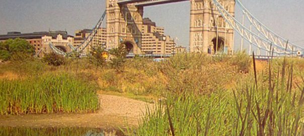

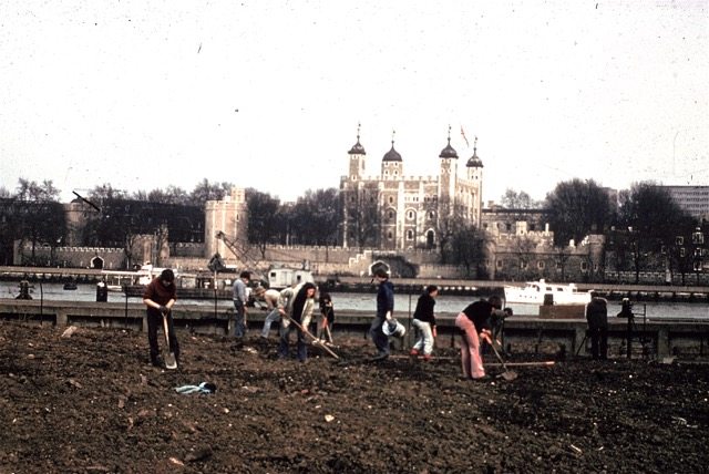
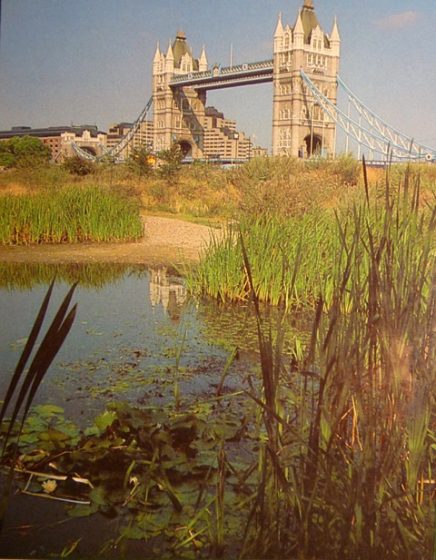
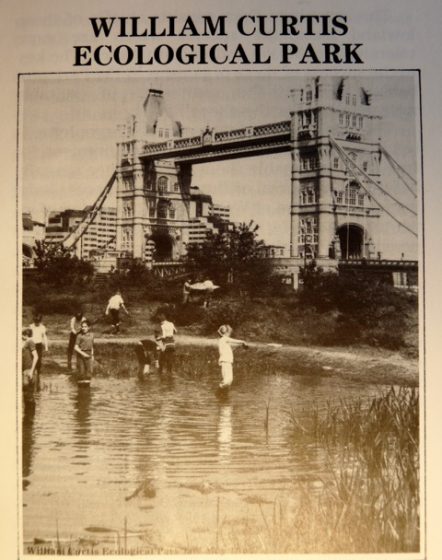
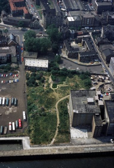
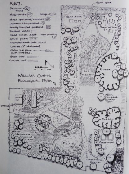
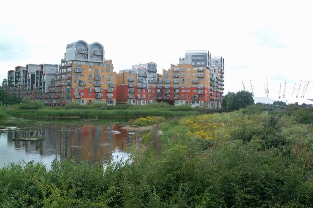
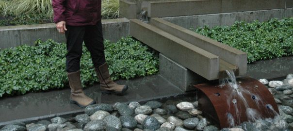


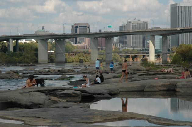
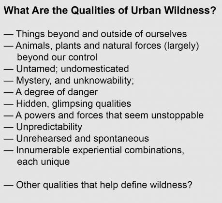 We need to replace the perceptual dichotomy that many still carry in our heads between cities and nature. The evolution in our thinking should encompass the new ways in which flora and fauna are evolving and adapting to cities and urbanization, and we’re only now beginning to understand this. Bird species are changing the frequencies of their songs in response to urban and traffic noise, for instance. And increasingly there are examples of “new” forms of nature, what ecologists sometimes call novel ecosystems, unique assemblages of native (and non-native species and habitats, that have formed in and around cities. Perhaps there is need for unplanned ecological spaces in our notions of urban wildness; making room in cities for a sort of ecological improvisation, with sometimes unexpected results. We will need to adjust our ideas about nature to include these ways in which the nature in the future will be different from what we previously have known.
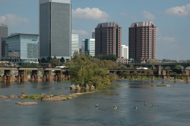
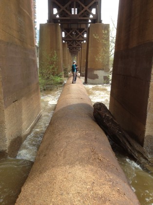
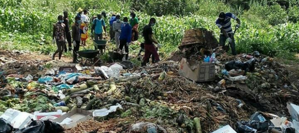
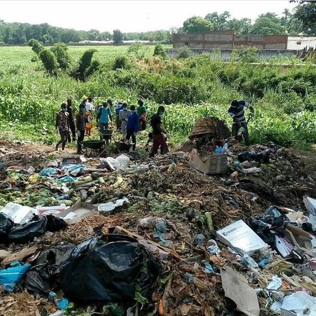
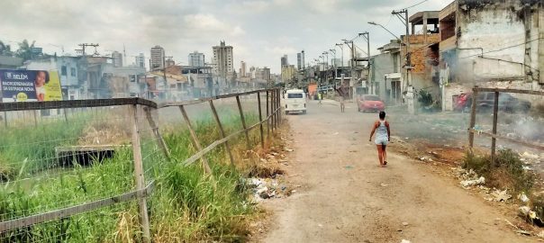
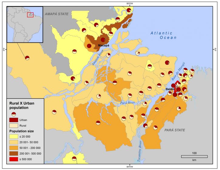
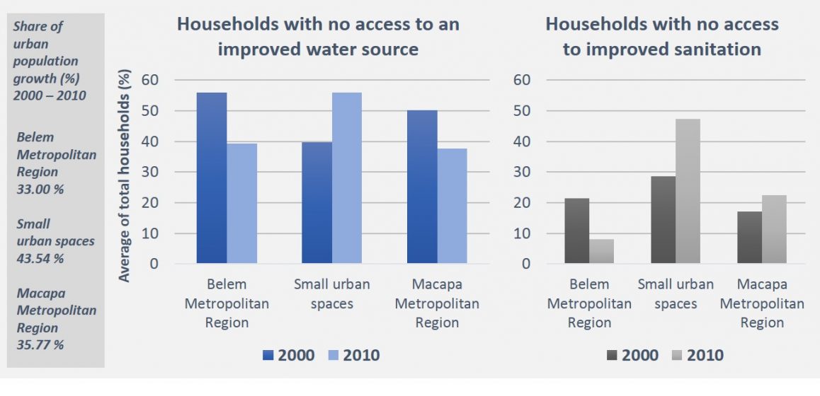
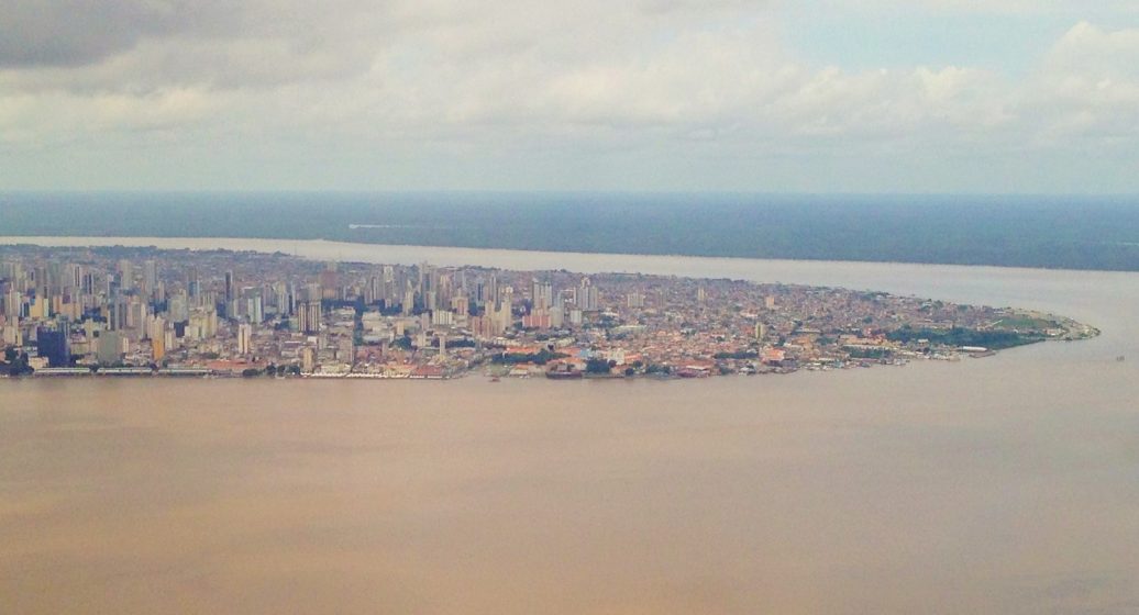
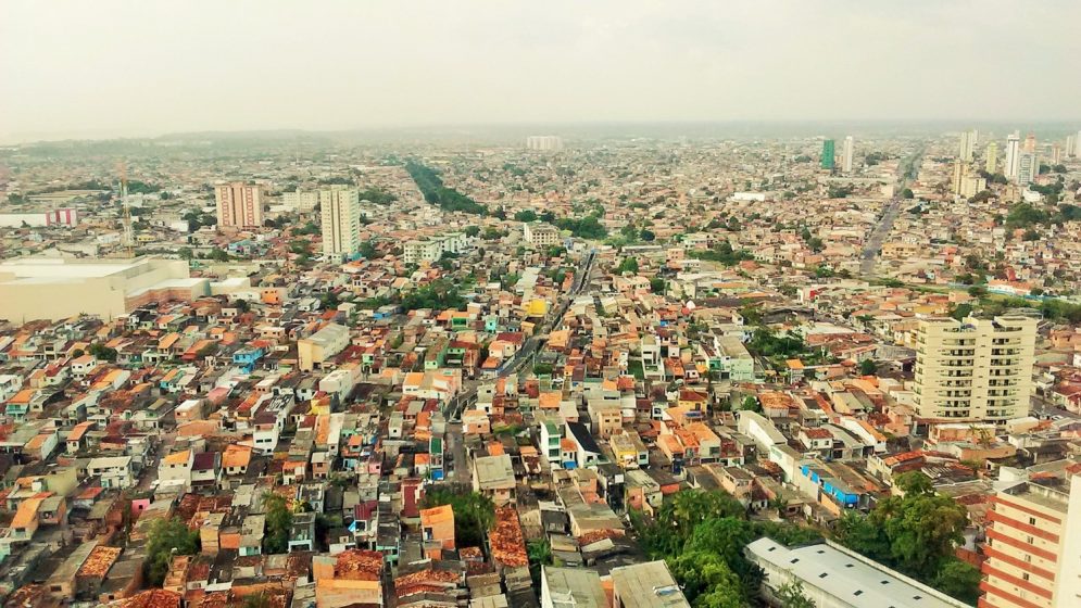
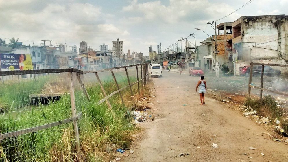
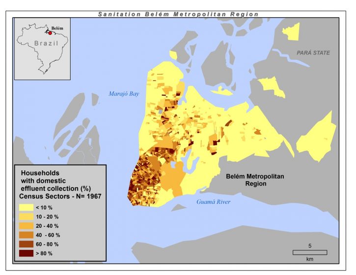
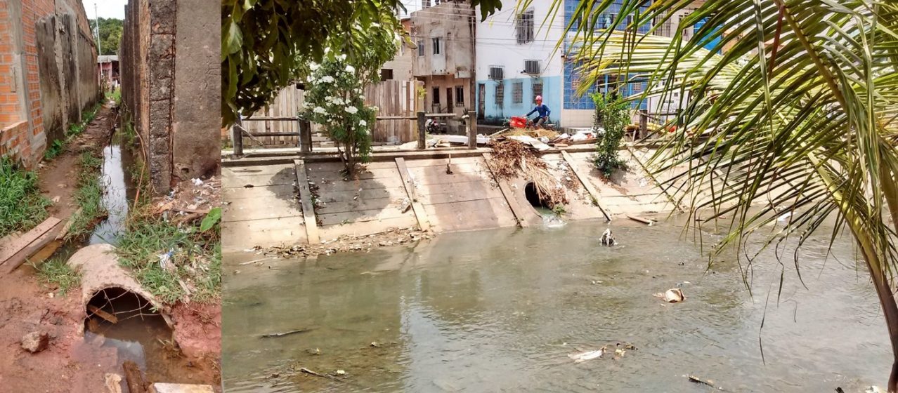
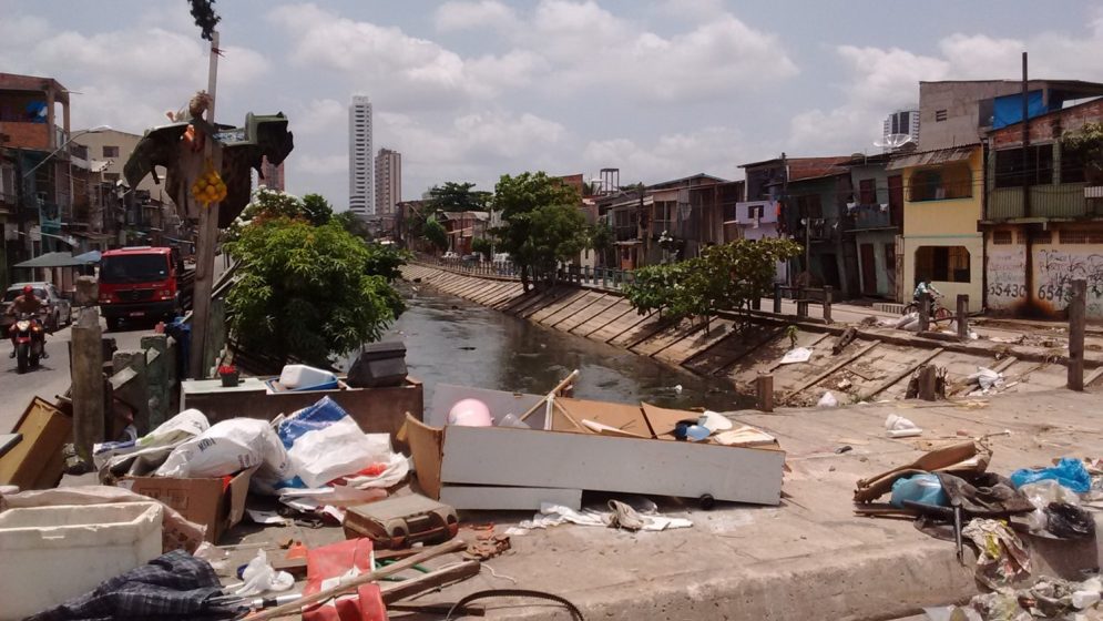
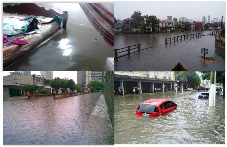
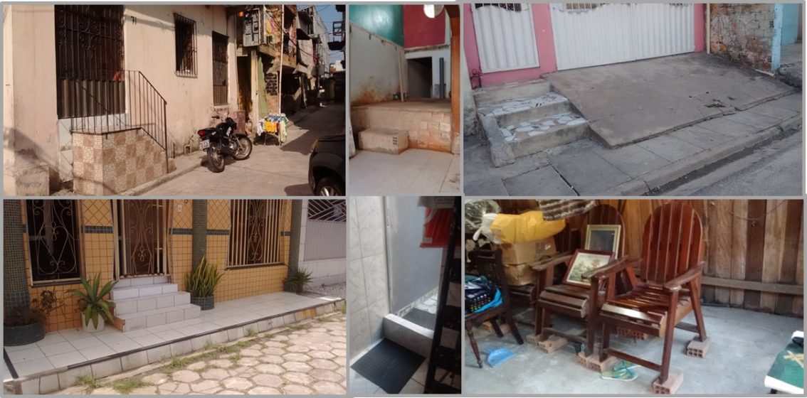
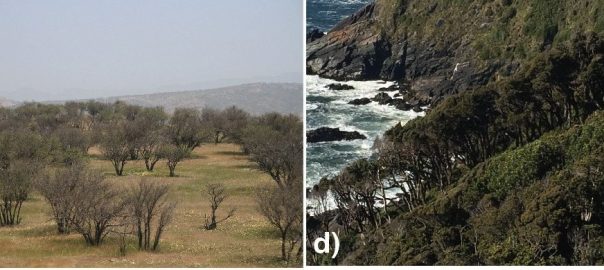
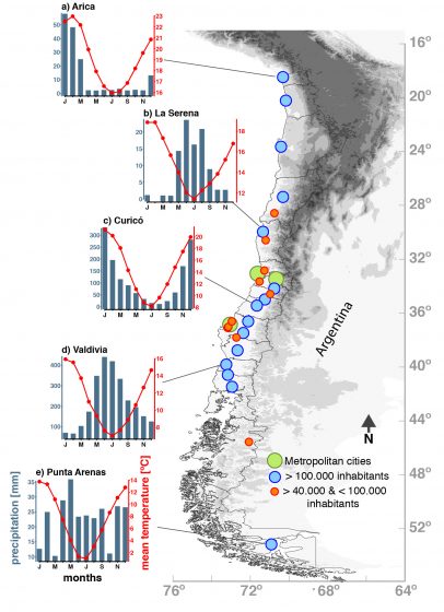
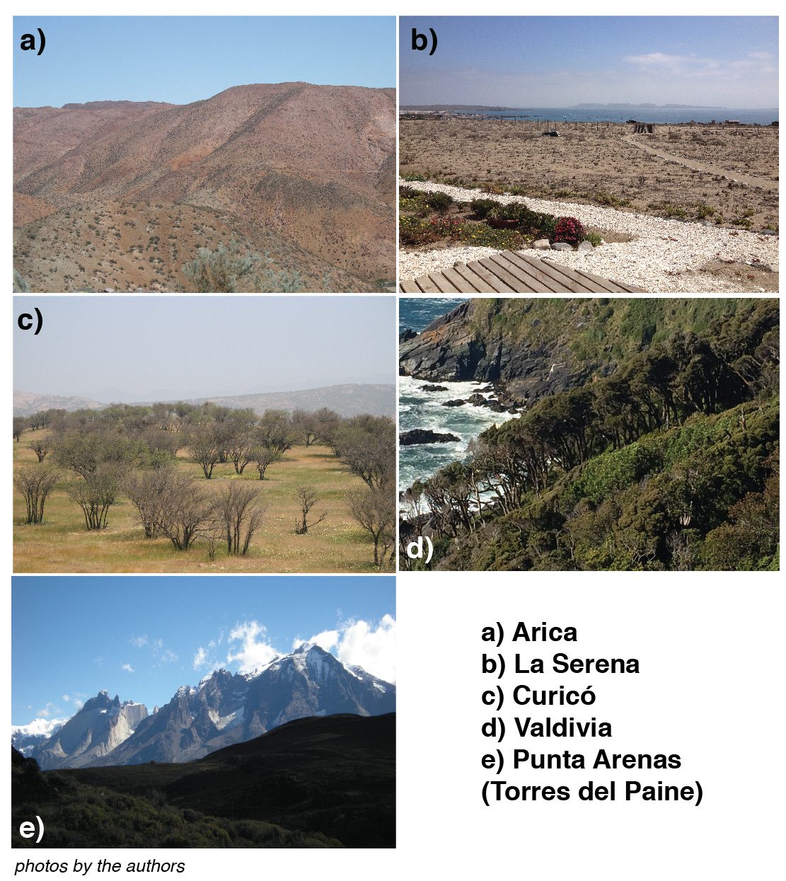


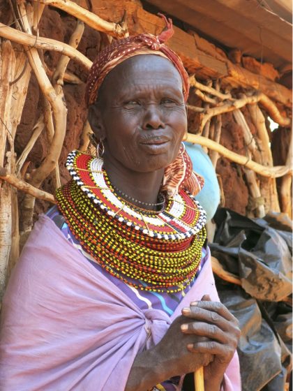
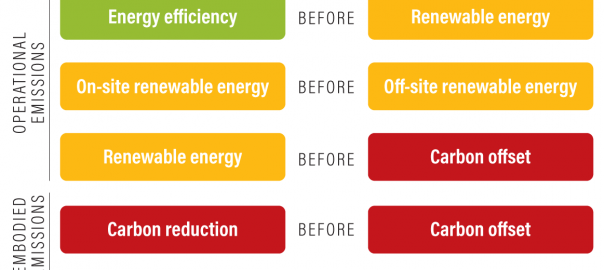
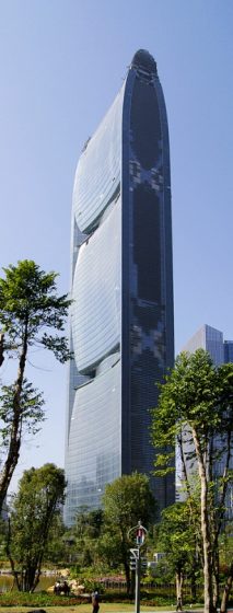
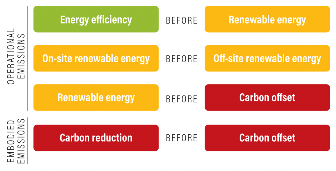
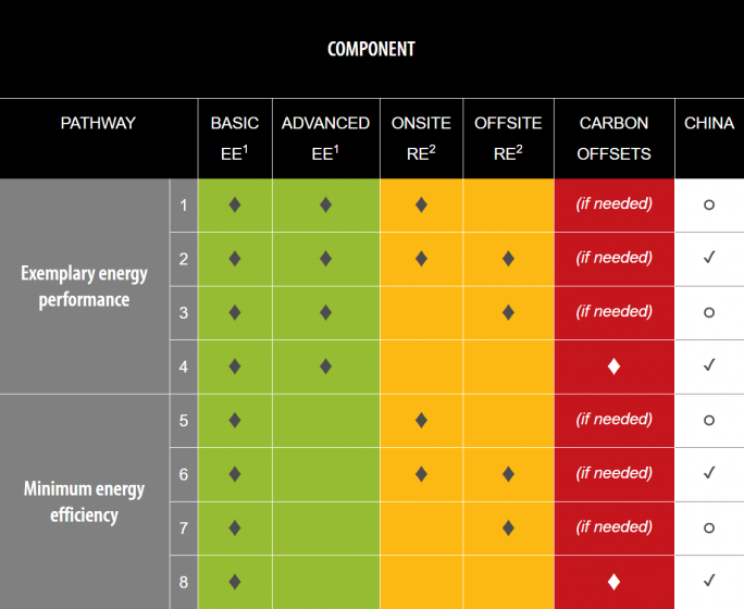
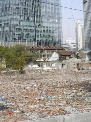

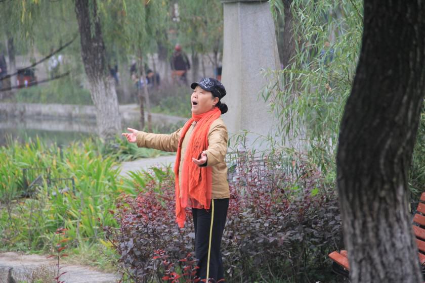
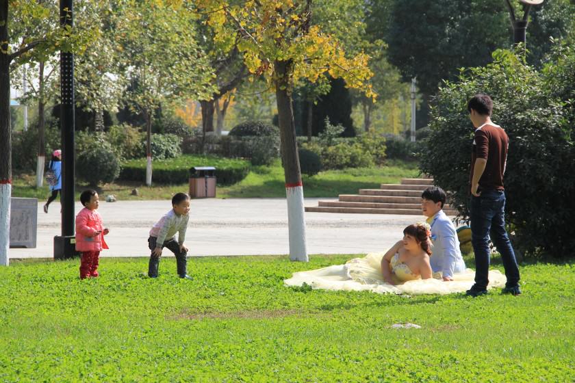
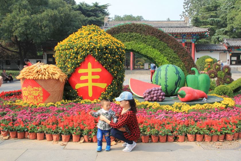
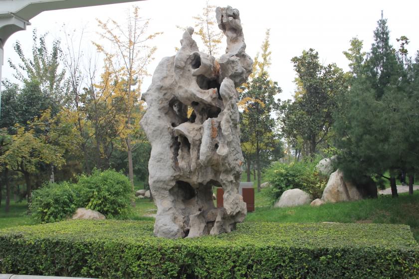
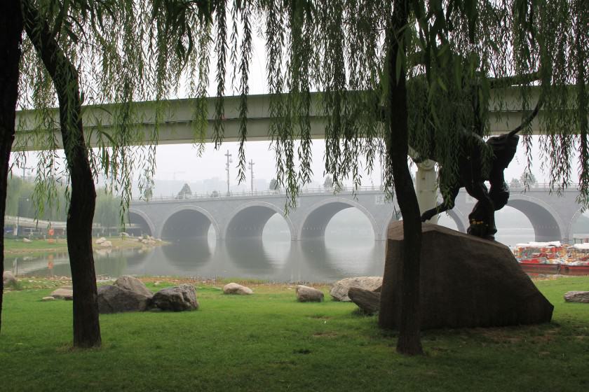


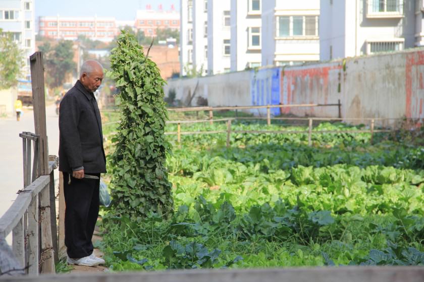
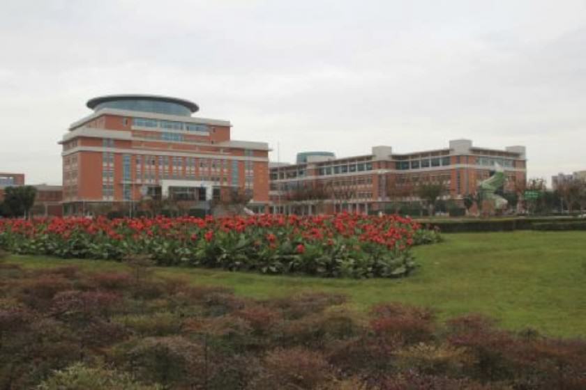


 Finally, the implications of urban expansion are both local and global, as ecosystems do not follow municipal or national boundaries. The displaced ecological impact of increased urban consumption highlights the importance of moving away from narrow place-based solutions to more broadly addressing concerns on ecological degradation and urban biodiversity concerns. It is time to recognize the overarching impact of an increasingly urbanized world and to design appropriate governance responses. This is further discussed in an
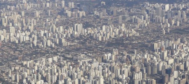


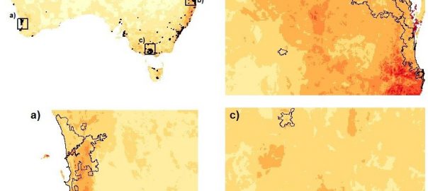
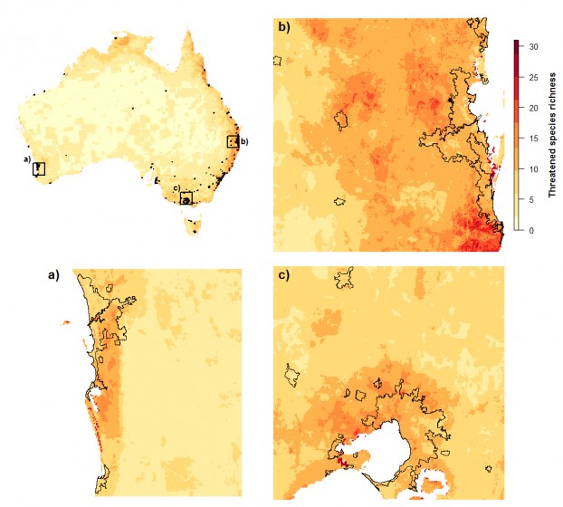
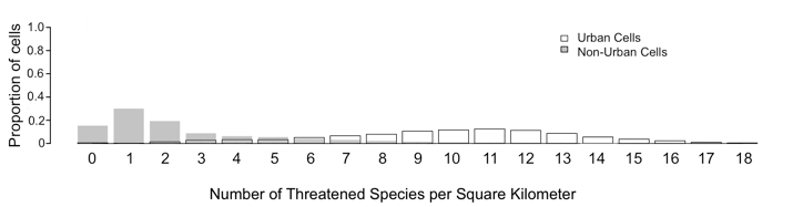
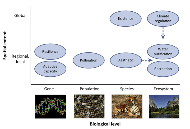
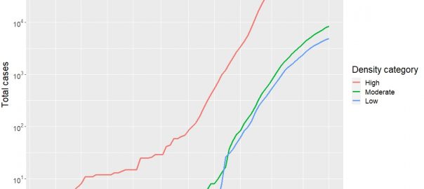
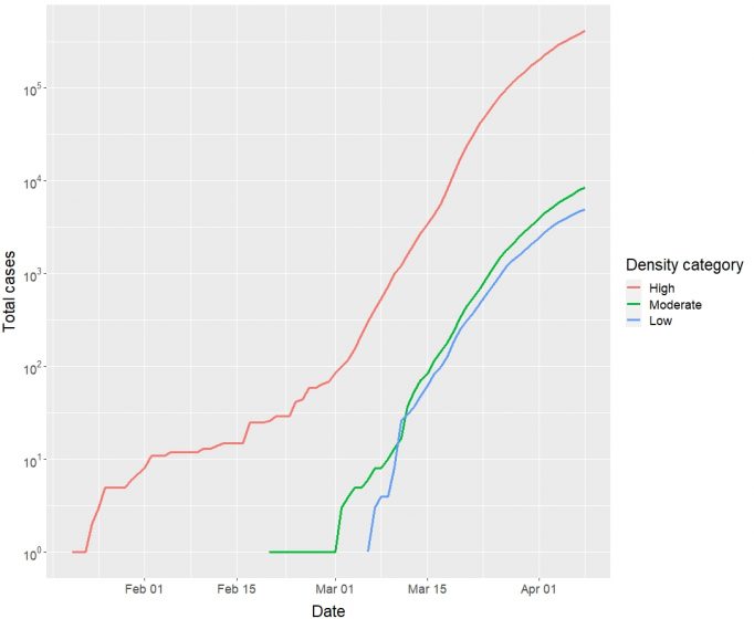
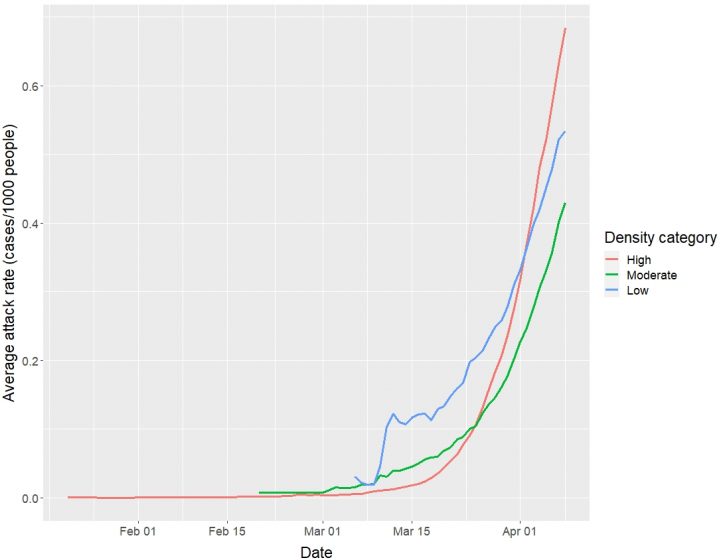
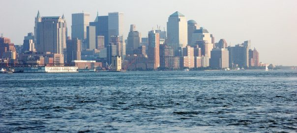
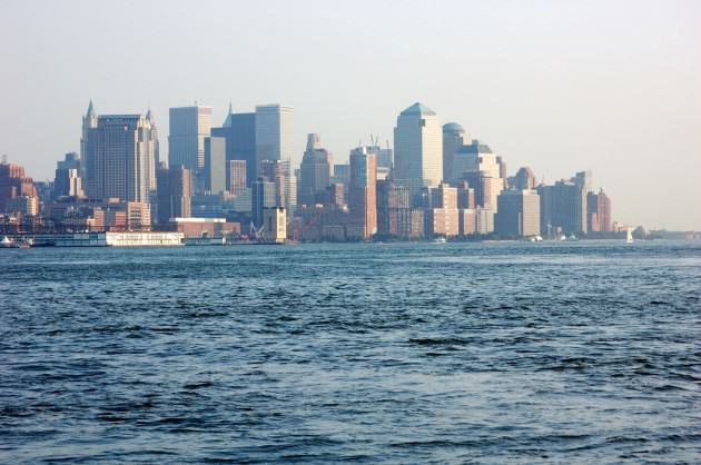

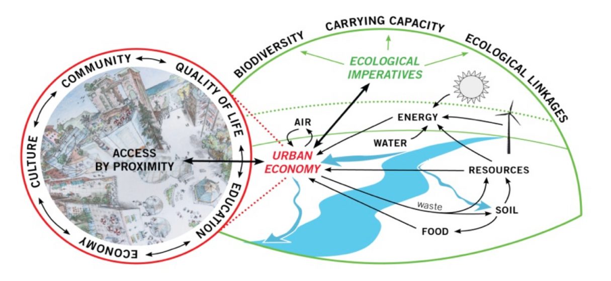
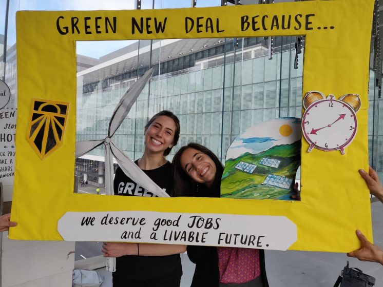

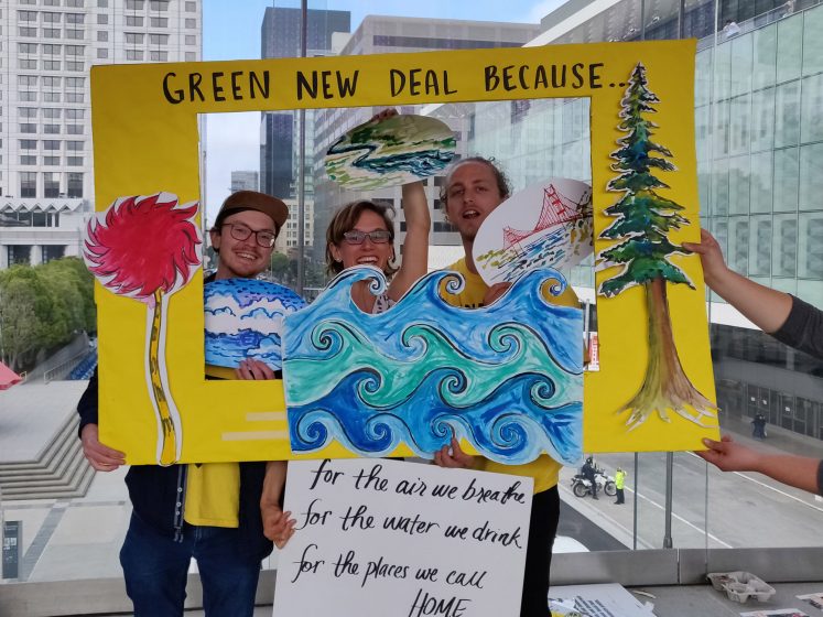
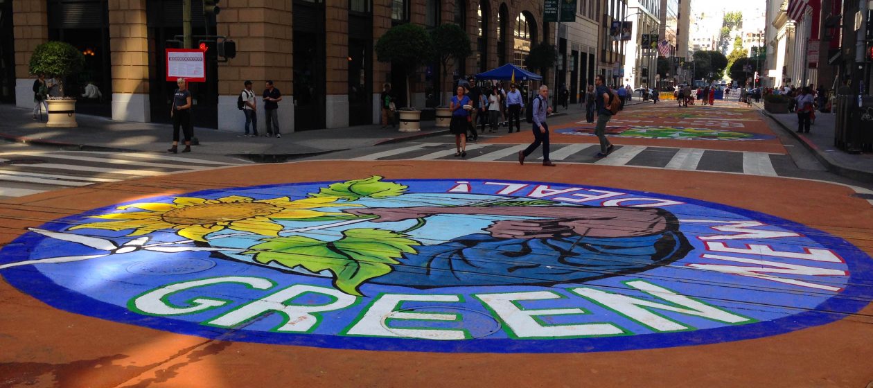

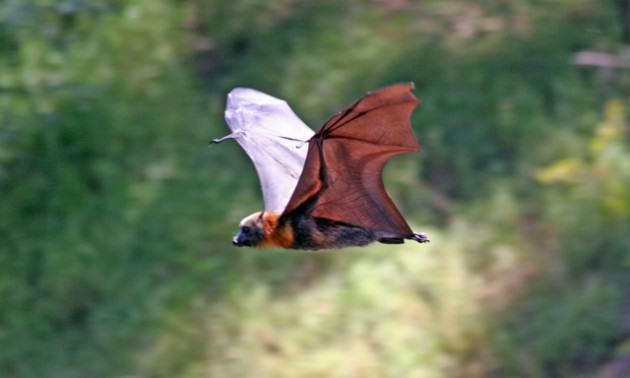
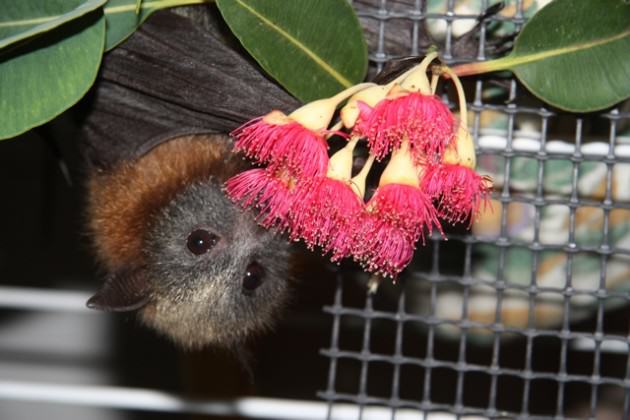
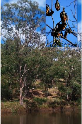
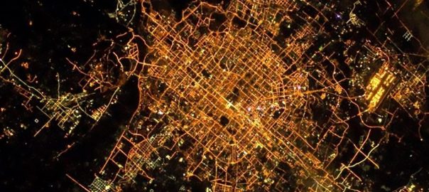

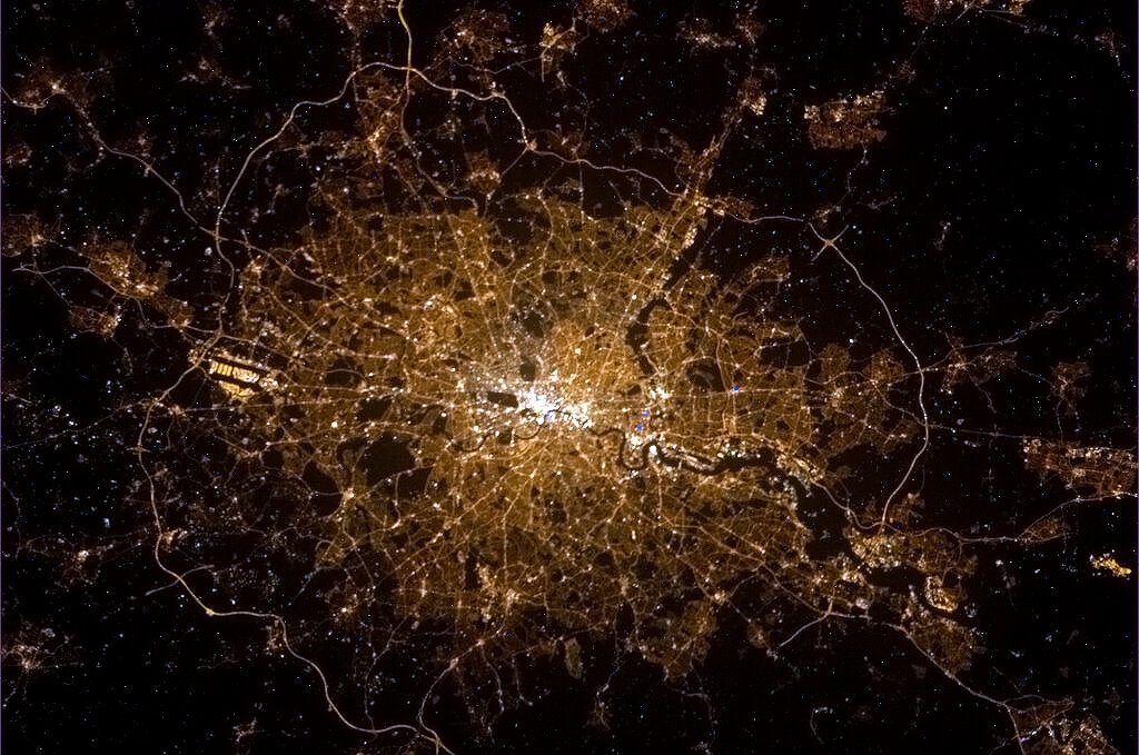
9 Comments
Join our conversation